
Geology of the Lassen volcanic area: Difference between revisions
copyedit |
m →Intro |
||
| (16 intermediate revisions by the same user not shown) | |||
| Line 1: | Line 1: | ||
{{vagueintro}} |
{{vagueintro}} |
||
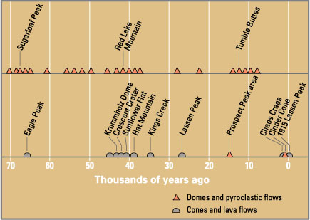
[[Image:Eruptions in the Lassen area in the last 50,000 years-map.jpg|thumb|300px|Eruptions in the Lassen volcanic area in the last 70,000 years. Circle shows the base of Tehama. See [[media:Eruptions in the Lassen area in the last 50,000 years.png|timeline image]]]] |
[[Image:Eruptions in the Lassen area in the last 50,000 years-map.jpg|thumb|300px|Eruptions in the Lassen volcanic area in the last 70,000 years. Circle shows the base of Tehama. See [[media:Eruptions in the Lassen area in the last 50,000 years.png|timeline image]]]] |
||
The '''geology of the Lassen volcanic area''' presents a record of sedimentation and |
The '''geology of the Lassen volcanic area''' presents a record of sedimentation and volcanic activity in the area in and around [[Lassen Volcanic National Park]] in [[Northern California]]. The park is located in the southernmost part of the [[Cascade Mountains | Cascade Mountain Range]] in the [[Pacific Northwest]] region of the [[United States]]. Oceanic [[plate tectonics | tectonic plates]] have plunged below the [[North American Plate]] in this part of [[North America]] for hundreds of millions of years. Heat from these [[Subduction|subducting]] plates has fed scores of [[volcano]]es in [[California]], [[Oregon]], [[Washington]] and [[British Columbia]] over at least the past 30 million years (see [[Geology of the Pacific Northwest]]). This is the same heat that fuels activity in the Lassen volcanic area. |
||
Between 2 and 4 million years ago, volcanic-derived mud flows called [[lahar]]s streamed down several major sources that included nearby but now extinct Mount Yana and Mount Maidu to become the [[Tuscan Formation]]. [[Basalt]]ic and later [[andesite | andesitic]] to [[dacite | dacitic]] flows of [[lava]] covered increasingly large areas of this formation to eventually form the [[lava plateau]] that the park sits on. About 600,000 years ago, [[Mount Tehama]] started to rise as a [[stratovolcano]] in the southeastern corner of the park, eventually reaching an estimated 11,000 feet (3,350 m) in height. Following a series of eruptions approximately 350,000 years ago, its cone collapsed into itself to form a two-mile wide [[caldera]]. |
|||
Roughly 27,000 years ago<!-- older sources give an age of 18,000 years-->, a dacite [[lava dome]] quickly pushed its way through Tehama's destroyed north-eastern flank, becoming |
Roughly 27,000 years ago<!-- older sources give an age of 18,000 years-->, a dacite [[lava dome]] quickly pushed its way through Tehama's destroyed north-eastern flank, becoming the approximately 1,000 feet (300 m) shorter [[Lassen Peak]]. Since then, smaller dacite domes such as the 1,100 year-old [[Chaos Crags]] formed around Lassen. [[Phreatic]] (steam explosion) eruptions, dacite and andesite lava flows along with [[cinder cone]] formation have persisted into modern times. Most notable of these is the 18th century formation of [[Cinder Cone and the Fantastic Lava Beds|Cinder Cone]] and the 1914 to 1921 eruption of Lassen Peak. The only activity since then has been the constant bubbling of [[mud pot]]s and steaming of [[fumarole]]s from the various [[geothermal areas in Lassen Volcanic National Park]]. However, the potential exists for renewed vigorous volcanic activity that could threaten life and property in the area. |
||
==Regional geologic setting== |
==Regional geologic setting== |
||
===Current setting=== |
===Current setting=== |
||
The Lassen volcanic area lies at the southern extremity of the [[Cascade Range]], which extends northward some 500 miles (800 km) from [[Lassen Peak]] within the park through [[Oregon]] and [[Washington]] and into [[British Columbia]]. Lassen Peak and the 16 other major [[Cascade Volcanoes]] form a segment of a ring of volcanoes that circle the [[Pacific Ocean]] known collectively as the '[[Pacific Ring of Fire]].' The Cascade Volcanoes are fed by heat generated as the [[Gorda Plate|Gorda]] and [[Juan de Fuca Plate|Juan de Fuca]] tectonic plates are being [[subduction|subducted]] below the much larger but lighter [[North American Plate]]. Lying some 300 miles (480 km) offshore, the [[divergent plate boundary|spreading center]] of the Gorda Plate pushes out about an inch (2.5 cm) of new crust toward the coast of Northernmost California and southern [[Oregon]] every year.<ref name="GeologyNP467">Harris, ''Geology of National Parks |
The Lassen volcanic area lies at the southern extremity of the [[Cascade Range]], which extends northward some 500 miles (800 km) from [[Lassen Peak]] within the park through [[Oregon]] and [[Washington]] and into [[British Columbia]]. Lassen Peak and the 16 other major [[Cascade Volcanoes]] form a segment of a ring of volcanoes that circle the [[Pacific Ocean]] known collectively as the '[[Pacific Ring of Fire]].' The Cascade Volcanoes are fed by heat generated as the [[Gorda Plate|Gorda]] and [[Juan de Fuca Plate|Juan de Fuca]] tectonic plates are being [[subduction|subducted]] below the much larger but lighter [[North American Plate]]. Lying some 300 miles (480 km) offshore, the [[divergent plate boundary|spreading center]] of the Gorda Plate pushes out about an inch (2.5 cm) of new crust toward the coast of Northernmost California and southern [[Oregon]] every year.<ref name="GeologyNP467">Harris, Ann (1997). ''Geology of National Parks'', page 467</ref> |
||
The composition of the molten rock (magma) that feeds volcanism in the Lassen volcanic area ranges widely in its content of [[silica]] ([[silicon|Si]][[oxygen|O]]<sub>2</sub>); the higher the silica content, the greater the ability of the magma to trap and hold onto gas and water vapor. When high-silica ([[dacite|dacitic]]) magma rises to the Earth's surface, the trapped gases and vapors can erupt explosively to produce ash clouds and [[pyroclastic flow]]s that consist of superheated gas, ash and volcanic fragments. Dacite magma that is extruded nonexplosively as lava forms [[lava dome]]s because it is too viscous (sticky) to flow far away from its source. Low-silica ([[basalt]]ic) magma is more fluid and usually erupts as lava in less explosive eruptions than dacite because gas and water vapor escape easily from it. Eruptions of basalt magma typically produce elongate lava flows, as well as build [[cinder cone]]s (piles of small frothy lava fragments or 'cinders') around volcanic vents.<ref name="VolcanoHazards"/> |
The composition of the molten rock (magma) that feeds volcanism in the Lassen volcanic area ranges widely in its content of [[silica]] ([[silicon|Si]][[oxygen|O]]<sub>2</sub>); the higher the silica content, the greater the ability of the magma to trap and hold onto gas and water vapor. When high-silica ([[dacite|dacitic]]) magma rises to the Earth's surface, the trapped gases and vapors can erupt explosively to produce ash clouds and [[pyroclastic flow]]s that consist of superheated gas, ash and volcanic fragments. Dacite magma that is extruded nonexplosively as lava forms [[lava dome]]s because it is too viscous (sticky) to flow far away from its source. Low-silica ([[basalt]]ic) magma is more fluid and usually erupts as lava in less explosive eruptions than dacite because gas and water vapor escape easily from it. Eruptions of basalt magma typically produce elongate lava flows, as well as build [[cinder cone]]s (piles of small frothy lava fragments or 'cinders') around volcanic vents.<ref name="VolcanoHazards"/> |
||
| Line 23: | Line 23: | ||
<!-- See talk: |
<!-- See talk: |
||
About 70 million years ago, the area where the Cascade Range is now situated was under the most recent encroachment by the Pacific Ocean.<ref name="NPS-Lassen-Volcanoes/Lava Flows">{{cite web|url=http://www.nps.gov/archive/lavo/pphtml/subnaturalfeatures39.html|publisher=National Park Service|title=Lassen Volcanic National Park|work=Nature & science, Volcanoes / Lava Flows|accessdate=2007-06-10}}</ref> The rocks that make up the modern Sierra Nevada and the [[Klamath Mountains]] were already in existence but deeply buried. Some 70 million years before (140 million years before present), the rocks that now make up the Klamaths broke away from the rocks that now make up the Sierras and moved 60 miles (100 km) west,<ref>Alt, ''Roadside Geology of Northern California'' |
About 70 million years ago, the area where the Cascade Range is now situated was under the most recent encroachment by the Pacific Ocean.<ref name="NPS-Lassen-Volcanoes/Lava Flows">{{cite web|url=http://www.nps.gov/archive/lavo/pphtml/subnaturalfeatures39.html|publisher=National Park Service|title=Lassen Volcanic National Park|work=Nature & science, Volcanoes / Lava Flows|accessdate=2007-06-10}}</ref> The rocks that make up the modern Sierra Nevada and the [[Klamath Mountains]] were already in existence but deeply buried. Some 70 million years before (140 million years before present), the rocks that now make up the Klamaths broke away from the rocks that now make up the Sierras and moved 60 miles (100 km) west,<ref>Alt, David (1986). ''Roadside Geology of Northern California'', page 193</ref> leaving the flooded 'Lassen Strait.' This broad depression was a [[seaway]] that connected the marine basin in [[California]] with that in east central Oregon.<ref name="NPS-Lassen-Volcanoes/Lava Flows"/> |
||
--> |
--> |
||
The entire western portion of [[North America]] was being deformed from the [[Laramide orogeny]] starting around 70 million years ago. Gradually during millions of years, crustal rocks were folded and fractured and the seas driven away. This same bending and breaking of rocks relieved pressure on the hot material beneath the earth's crust and permitted [[magma]] to rise toward the surface. Volcanoes burst into activity starting 30 million years ago from Washington southward along the Cascades and in the area now occupied by the Sierra Nevada mountain range.<ref name="RoadsideNCal194">Alt, ''Roadside Geology of Northern California'' |
The entire western portion of [[North America]] was being deformed from the [[Laramide orogeny]] starting around 70 million years ago. Gradually during millions of years, crustal rocks were folded and fractured and the seas driven away. This same bending and breaking of rocks relieved pressure on the hot material beneath the earth's crust and permitted [[magma]] to rise toward the surface. Volcanoes burst into activity starting 30 million years ago from Washington southward along the Cascades and in the area now occupied by the Sierra Nevada mountain range.<ref name="RoadsideNCal194">Alt, David (1986). ''Roadside Geology of Northern California'', page 194</ref> This activity continued until approximately 11 or 12 million years ago.<ref name="NPS-Lassen-Volcanoes/Lava Flows"/> Lava and ash reached a thickness of up to 10,000 feet (about 3,000 m) in some areas, forming what is now known as the western Cascades.<ref name="NPS-Lassen-Volcanoes/Lava Flows"/> These have been eroded until they are now rolling hills. |
||
Meanwhile, toward the end of this activity, eruptions of a different kind took place on an unprecedented scale in eastern Oregon and Washington. From innumerable cracks, floods of highly fluid basaltic lava spread to cover an area of over 200,000 square miles (500,000 km²).<ref name="NPS-Lassen-Volcanoes/Lava Flows"/> Now known as the [[Columbia Plateau]], this great lava bed of [[flood basalt]] covers much of Oregon, Washington and even parts of [[Idaho]]. Northern California's [[Modoc Plateau]] is a thinner basaltic flow which some geologists associate with the Columbia Plateau, but there are technical objections to this.<ref name="NPS-Lassen-Volcanoes/Lava Flows"/> The [[High Cascades]] took shape as a distinct mountain belt as a result of this upheaval and the bending of the thick blanket of volcanic rocks. During the next 10 million years, a series of new basaltic volcanic cones similar to the [[shield volcano]]es now found in [[Hawaii]] were built. |
Meanwhile, toward the end of this activity, eruptions of a different kind took place on an unprecedented scale in eastern Oregon and Washington. From innumerable cracks, floods of highly fluid basaltic lava spread to cover an area of over 200,000 square miles (500,000 km²).<ref name="NPS-Lassen-Volcanoes/Lava Flows"/> Now known as the [[Columbia Plateau]], this great lava bed of [[flood basalt]] covers much of Oregon, Washington and even parts of [[Idaho]]. Northern California's [[Modoc Plateau]] is a thinner basaltic flow which some geologists associate with the Columbia Plateau, but there are technical objections to this.<ref name="NPS-Lassen-Volcanoes/Lava Flows"/> The [[High Cascades]] took shape as a distinct mountain belt as a result of this upheaval and the bending of the thick blanket of volcanic rocks. During the next 10 million years, a series of new basaltic volcanic cones similar to the [[shield volcano]]es now found in [[Hawaii]] were built. |
||
| Line 32: | Line 32: | ||
==Formation of basement rocks == |
==Formation of basement rocks == |
||
Between two and three million years ago, during the [[Pliocene]], the [[Sierra Nevada (US)|Sierra Nevada]] was uplifted and tilted westward. A series of volcanic mudflows ([[lahar]]s) from three major source areas contributed debris that covered almost {{Unit square mile|2000|-2}} to form the oldest distinctive [[geologic formation]] in the High Cascades.<ref name="NPS-Lassen-Volcanoes/Lava Flows"/> The resulting [[Tuscan Formation]] is not exposed anywhere in the national park but it is just below the surface in many places within it.<ref>Harris, Ann (1997). ''Geology of National Parks'', page 472</ref> The oldest pyroclastic material in the formation is 3 <ref name="GUSP156">Kiver, Eugene (1999). ''Geology of U.S. Parklands'', page 156</ref> or 4 <ref name="CSUtuscan">{{cite web|url=http://www.csuchico.edu/atec/projects/tigers/site/formations/tuscan.html|title=Virtual Field Trip: Geologic Lessens in the Northern California Foothills|work=The Tuscan Formation|publisher=California State University, Chico|editor=Dr. Vic Fisher|accessdate=2007-07-09}}</ref> million years old. The youngest part of the formation consists of interbedded conglomerates and volcanic breccias that are 2 million years old.<ref name="CSUtuscan"/> |
|||
One major source of the formation was Mount Yana; centered a few miles (5 km) southwest of Butt Mountain and south of the park. Mount Yana had probably reached its full size of 10,000 feet (3,000 m) in elevation and 15 miles (24 km) in diameter before Mount Maidu, the second source, had acquired half its growth. Mount Maidu, which eventually surpassed Mount Yana in size, was centered over what is now the town of [[Mineral, California]] but has been extinct for hundreds of thousands of years (the grassy plain around the town is Maidu's [[caldera]]).<ref name="FireMountains73">Harris, Stephen (2001).. ''Fire Mountains of the West'', page 73</ref> A third source situated north of Latour Butte made a lesser contribution to the formation. Minor sources included an area near Hatchet Mountain Pass (northwest of Burney Mountain), dikes south and southwest of Inskip Hill and possibly Campbell Mound (north of [[Chico, California]]).<ref name="NPS-Lassen-Volcanoes/Lava Flows"/> |
|||
Meanwhile, within the park boundary other volcanic events were taking place. Basaltic lavas poured forth in the vicinity of Willow Lake in the southwestern portion of the park.<ref name="GNP473">Harris, ''Geology of National Parks'' |
Meanwhile, within the park boundary other volcanic events were taking place. Basaltic lavas poured forth in the vicinity of Willow Lake in the southwestern portion of the park.<ref name="GNP473">Harris, Ann (1997). ''Geology of National Parks'', page 473</ref> These were followed by a very thick sequence of very fluid [[andesite|andesitic]] lavas which erupted near Juniper Lake and flowed westward about four miles.<ref name="NPS-Lassen-Volcanoes/Lava Flows"/> At about the same time, other andesitic lavas poured from several vents on the central [[plateau]] to cover an area of at least 30 square miles (80 km²). Included among these flows were the Twin Lake lavas of black porphyritic andesite, which are notable in that they contain [[xenocryst]]s of [[quartz]].<ref name="GNP474">Harris, Ann (1997). ''Geology of National Parks'', page 474</ref> The Flatiron andesites spread over the southwestern part of the park area around this time. Apparently, the vents of these lavas renewed activity at a much later date to form three [[cinder cone]]s: Hat Mountain, Crater Butte and Fairfield Peak. |
||
Somewhat later, andesitic lavas poured out from what is now Reading Peak and mainly flowed to the south and east, reaching the head of Warner Valley. By this time, the park's eastern portion had been transformed into a relatively flat plain.<ref name="NPS-Lassen-Volcanoes/Lava Flows"/> The activity was followed by an eruption of the Eastern basalts from volcanoes east of the park.<ref name="GNP474"/> These thick flows have subsequently eroded to produce rugged hills that limit the park on the east. Taken together, these various flows built the lava plateau that the Lassen volcanic area is located on.<ref name="GNP473">Harris, ''Geology of National Parks'' |
Somewhat later, andesitic lavas poured out from what is now Reading Peak and mainly flowed to the south and east, reaching the head of Warner Valley. By this time, the park's eastern portion had been transformed into a relatively flat plain.<ref name="NPS-Lassen-Volcanoes/Lava Flows"/> The activity was followed by an eruption of the Eastern basalts from volcanoes east of the park.<ref name="GNP474"/> These thick flows have subsequently eroded to produce rugged hills that limit the park on the east. Taken together, these various flows built the lava plateau that the Lassen volcanic area is located on.<ref name="GNP473">Harris, Ann (1997). ''Geology of National Parks'', page 473</ref> |
||
==Volcanoes rise and fall in the park area== |
==Volcanoes rise and fall in the park area== |
||
| Line 44: | Line 44: | ||
[[Image:Rockland Ash map.png|thumb|<small>The Rockland Ash erupted about 600,000 years ago from Mount Tehama (some sources give a date of 400,000 before present<ref>{{cite journal|url=http://earthref.org/cgi-bin/er.cgi?s=err.cgi%3Fn%3D12694 | author = Alloway, B.V., Westgate, J.A., Sandhu, A.S. and Bright, R.C.|year=1992|title=Isothermal plateau fission-track age and revised distribution of the widespread mid-Pleistocene Rockland tephra in west-central United States|journal=Geophysical Research Letters 19(6)|doi=10.1029/92GL00358|issn=0094-8276}} |
[[Image:Rockland Ash map.png|thumb|<small>The Rockland Ash erupted about 600,000 years ago from Mount Tehama (some sources give a date of 400,000 before present<ref>{{cite journal|url=http://earthref.org/cgi-bin/er.cgi?s=err.cgi%3Fn%3D12694 | author = Alloway, B.V., Westgate, J.A., Sandhu, A.S. and Bright, R.C.|year=1992|title=Isothermal plateau fission-track age and revised distribution of the widespread mid-Pleistocene Rockland tephra in west-central United States|journal=Geophysical Research Letters 19(6)|doi=10.1029/92GL00358|issn=0094-8276}} |
||
</ref>). That event was 50 times larger than the [[1980 eruption of Mount St. Helens]].</small>]] |
</ref>). That event was 50 times larger than the [[1980 eruption of Mount St. Helens]].</small>]] |
||
From 600,000 to 400,000 years ago, eruptions built a large conical [[stratovolcano]] called [[Mount Tehama]] (also called Brokeoff Volcano) in what is now the southwest corner of the park.<ref name="VolcanoHazards">{{cite web|url=http://pubs.usgs.gov/fs/2000/fs022-00/|title=Volcano Hazards of the Lassen Volcanic National Park Area, California (Fact Sheet 022-00, Online version 1.0)|publisher=United States Geological Survey|accessdate=2006-09-25}}</ref> It was made of roughly alternating layers of andesitic lavas and [[tephra]] ([[volcanic ash]], [[breccia]], and [[pumice]]) with increasing amounts of tephra with elevation.<ref name="GNP474"/> |
From 600,000 to 400,000 years ago,<ref name="Clynne1990">{{cite journal|journal=Journal of Geophysical Research|url=http://www.osti.gov/energycitations/product.biblio.jsp?osti_id=5195620|author=Clynne, M.A.|issn=0148-0227|title=Stratigraphic, lithologic, and major element geochemical constraints on magmatic evolution at Lassen volcanic center, California|year=1990}}</ref> eruptions built a large conical [[stratovolcano]] called [[Mount Tehama]] (also called Brokeoff Volcano) in what is now the southwest corner of the park.<ref name="VolcanoHazards">{{cite web|url=http://pubs.usgs.gov/fs/2000/fs022-00/|title=Volcano Hazards of the Lassen Volcanic National Park Area, California (Fact Sheet 022-00, Online version 1.0)|publisher=United States Geological Survey|accessdate=2006-09-25}}</ref> It was made of roughly alternating layers of andesitic lavas and [[tephra]] ([[volcanic ash]], [[breccia]], and [[pumice]]) with increasing amounts of tephra with elevation.<ref name="GNP474"/> |
||
Tehama started its activity while Mount Yana was still active but before Mount Maidu erupted for the fist time. Tehama eventually reached an elevation of about 11,000 feet (3,400 m)<ref name="FireMountains73"/> |
Tehama started its activity while Mount Yana was still active but before Mount Maidu erupted for the fist time. Tehama eventually reached an elevation of about 11,000 feet (3,400 m)<ref name="FireMountains73"/>, was 11 to 15 miles (18 to 24 km) wide at its base<ref name="GNP466">Harris, Ann (1997). ''Geology of National Parks'', page 466</ref>, and contained 80 km³ of material.<ref name="Clynne1990"/> Its principal vent lay in the neighborhood of what is now [[Sulphur Works]], but a second vent from which no lavas issued lay on the eastern flank of [[Little Hot Springs Valley]]. Contrary to popular belief, [[Bumpass Hell]] is not one of Tehama's main vents since it is located outside of the [[caldera]].<ref name="NPS-Lassen-Volcanoes/Lava Flows"/> |
||
[[Image:Geothermal areas in Lassen area.png|thumb|left|Extent of Tehama shown by outline]] |
[[Image:Geothermal areas in Lassen area.png|thumb|left|Extent of Tehama shown by outline]] |
||
It is possible that Tehama collapsed along a series of fault lines which criss-crossed it. The trigger for this possible collapse may have been the release of the extensive amounts of lava that formed the dacite domes on its flank. More likely, the volcano weathered away; hot volcanic gases and steam turned hard rock into soft clay that were easily eroded by glacial action.<ref name="FireMountains75"/> Either way, the largest remnants of Tehama include Brokeoff Mountain, Mount Conard, Mount Diller, and Pilot Pinnacle.<ref name="GeologyNP467">Harris, ''Geology of National Parks'' |
It is possible that Tehama collapsed along a series of fault lines which criss-crossed it. The trigger for this possible collapse may have been the release of the extensive amounts of lava that formed the dacite domes on its flank. More likely, the volcano weathered away; hot volcanic gases and steam turned hard rock into soft clay that were easily eroded by glacial action.<ref name="FireMountains75"/> Either way, the largest remnants of Tehama include Brokeoff Mountain, Mount Conard, Mount Diller, and Pilot Pinnacle.<ref name="GeologyNP467">Harris, Ann (1997). ''Geology of National Parks'', page 467</ref> Andesites erupted again in the area starting 300,000 before the present (bp) and dacite erupted in the area between 250,000 to 200,000 years ago and 100,000 bp through the present.<ref name="Clynne1990"/> |
||
Four [[shield volcano]]es (Raker and Prospect Peaks, Sifford Mountain and Mount Harkness) grew to elevations of between 7,000 to 8,400 feet (2,130 to 2,560 m) at the corners of the central plateau.<ref name="GNP470">Harris, ''Geology of National Parks'' |
Four [[shield volcano]]es (Raker and Prospect Peaks, Sifford Mountain and Mount Harkness) grew to elevations of between 7,000 to 8,400 feet (2,130 to 2,560 m) at the corners of the central plateau.<ref name="GNP470">Harris, Ann (1997). ''Geology of National Parks'', page 470</ref> Raker Peak erupted andesite lavas while basalt flowed from the others. Each of these volcanoes developed a cinder cone on its summit during their last stages of [[volcanic eruption|eruption]]. Later, a mass of [[rhyolite]] was forced through the north flank of Sifford Mountain and a plug of [[dacite]] was pushed up through the west flank of Raker Peak.<ref name="NPS-Lassen-Volcanoes/Lava Flows"/> |
||
In the past 50,000 years, at least seven major episodes of dacitic volcanism produced [[lava dome]]s and pyroclastic deposits in the Lassen volcanic area, and another five episodes produced basaltic and [[andesite|andesitic]] ([[silica]] content between basalt and dacite) lava flows.<ref name="VolcanoHazards"/> Eruptions have occurred at sites including Lassen Peak, Chaos Crags, and Sunflower Flat (explosive dacite eruptions followed by dome growth) and Tumble Buttes, Hat Mountain, and Prospect Peak (basalt eruptions).<ref name="VolcanoHazards"/> In addition, about 30 smaller volcanoes erupted basaltic lavas in the larger region surrounding the Lassen volcanic center.<ref name="VolcanoHazards"/> |
In the past 50,000 years, at least seven major episodes of dacitic volcanism produced [[lava dome]]s and pyroclastic deposits in the Lassen volcanic area, and another five episodes produced basaltic and [[andesite|andesitic]] ([[silica]] content between basalt and dacite) lava flows.<ref name="VolcanoHazards"/> Eruptions have occurred at sites including Lassen Peak, Chaos Crags, and Sunflower Flat (explosive dacite eruptions followed by dome growth) and Tumble Buttes, Hat Mountain, and Prospect Peak (basalt eruptions).<ref name="VolcanoHazards"/> In addition, about 30 smaller volcanoes erupted basaltic lavas in the larger region surrounding the Lassen volcanic center.<ref name="VolcanoHazards"/> |
||
| Line 57: | Line 57: | ||
===Development of Lassen Peak=== |
===Development of Lassen Peak=== |
||
[[Image:Lassen_Peak_from_the_summit_of_Brokeoff_Mountain-1200px.jpg|thumb|left|250px|Lassen Peak from the summit of Brokeoff Mountain. Photo shows 1915 tongue of lava and Volcan's Eye]] |
[[Image:Lassen_Peak_from_the_summit_of_Brokeoff_Mountain-1200px.jpg|thumb|left|250px|Lassen Peak from the summit of Brokeoff Mountain. Photo shows 1915 tongue of lava and Volcan's Eye]] |
||
[[Radiometric dating]] indicates that around 31,000 years ago a new vent opened up on the northeastern slope of Tehama, probably close to where [[Lassen Peak]] now stands.<ref name="GUSP159">Kiver, ''Geology of U.S. Parklands'' |
[[Radiometric dating]] indicates that around 31,000 years ago a new vent opened up on the northeastern slope of Tehama, probably close to where [[Lassen Peak]] now stands.<ref name="GUSP159">Kiver, Eugene (1999). ''Geology of U.S. Parklands'', page 159</ref> Streams of fluid dacite flowed chiefly toward the north, reaching a thickness of 1,500 feet (460 m) and covering perhaps 20 square miles (50 sq km).<ref name="NPS-Lassen-Volcanoes/Lava Flows"/><ref name="FireMountains75">Harris, Stephen (2001). ''Fire Mountains of the West'', page 75</ref> Known as the Loomis Sequence,<ref name="FireMountains75"/> these pre-Lassen dacites are the black, glassy, columnar lavas that now encircle Lassen Peak.<ref name="GNP474"/> |
||
Sometime between 25,000 and 31,000 years ago, Lassen Peak, a Pelean lava dome volcano, was pushed up through the pre-Lassen dacites.<ref name="GUSP159"/> Lassen grew past the normal maximum size of plug dome volcanoes, 1,000 feet (300 m), and reached a height of 1,800 feet (550 m) above the surrounding plateau<ref name = "GUSP159"/> in as little as a few years. The surface of the growing pile of about a cubic mile (4 km³) of lava<ref name="GeologyNP467"/> crumbled continually, forming enormous banks of [[talus]].<ref name="GNP466"/> When Lassen Peak formed it looked much like the nearby [[Chaos Crags]] domes do today, with steep sides covered by angular rock talus. Lassen Peak’s shape was significantly altered by glacial erosion from 25,000 to 18,000 years ago during the [[Wisconsin glaciation]].<ref name="VolcanoHazards"/> At least one of Lassen's glaciers extended as far as 7 miles (11 km) from the volcano itself. |
Sometime between 25,000 and 31,000 years ago, Lassen Peak, a Pelean lava dome volcano, was pushed up through the pre-Lassen dacites.<ref name="GUSP159"/> Lassen grew past the normal maximum size of plug dome volcanoes, 1,000 feet (300 m), and reached a height of 1,800 feet (550 m) above the surrounding plateau<ref name = "GUSP159"/> in as little as a few years. The surface of the growing pile of about a cubic mile (4 km³) of lava<ref name="GeologyNP467"/> crumbled continually, forming enormous banks of [[talus]].<ref name="GNP466"/> When Lassen Peak formed it looked much like the nearby [[Chaos Crags]] domes do today, with steep sides covered by angular rock talus. Lassen Peak’s shape was significantly altered by glacial erosion from 25,000 to 18,000 years ago during the [[Wisconsin glaciation]].<ref name="VolcanoHazards"/> At least one of Lassen's glaciers extended as far as 7 miles (11 km) from the volcano itself. |
||
| Line 72: | Line 72: | ||
===Post glacial to 19th century activity=== |
===Post glacial to 19th century activity=== |
||
Subsequent to the rise of Lassen Peak, several dacitic [[pumice]] cones developed in a rift extending northwest from the base of Lassen Peak. Then about 1,100 years ago several dacitic domes, the [[Chaos Crags]], protruded through these cones and obliterated all but half of the southernmost cone. At least 300 years ago a series of large avalanches, possibly triggered by [[phreatic eruption|steam explosions]], occurred on the north side of the Crags.<ref name = "GUSP160">Kiver, ''Geology of U.S. Parklands'' |
Subsequent to the rise of Lassen Peak, several dacitic [[pumice]] cones developed in a rift extending northwest from the base of Lassen Peak. Then about 1,100 years ago several dacitic domes, the [[Chaos Crags]], protruded through these cones and obliterated all but half of the southernmost cone. At least 300 years ago a series of large avalanches, possibly triggered by [[phreatic eruption|steam explosions]], occurred on the north side of the Crags.<ref name = "GUSP160">Kiver, Eugene (1999). ''Geology of U.S. Parklands'', page 160</ref> These avalanches created their own 'air cushions' that helped accelerate them to speeds exceeding 100 miles per hour (160 km/ph) and push them partway up Table Mountain.<ref name="GUSP160"/> The resulting wilderness of debris, the Chaos Jumbles, covers an area of {{Unit square mile|2.5|0}}.<ref name="NPS-Lassen-Volcanoes/Lava Flows"/> Manzanita Lake was formed as a result of Manzanita Creek being dammed by the debris.<ref name="GNP470"/> Steam rose from the domes of Chaos Crags until 1857.<ref name="GUSP160"/> |
||
[[Image:Cinder Cone and the Fantastic Lava Beds.jpg|thumb|False color air photo of Cinder Cone and the Fantastic Lava Beds.]] |
[[Image:Cinder Cone and the Fantastic Lava Beds.jpg|thumb|False color air photo of Cinder Cone and the Fantastic Lava Beds.]] |
||
Around the mid 18th century a series of eruptions produced [[Cinder Cone and the Fantastic Lava Beds|Cinder Cone]] in the northeast corner of the park, mantling an area of 30 square miles (80 km²) with ejecta in the process.<ref name="NPS-Lassen-Volcanoes/Lava Flows"/> Ash falling on the streams of lava pouring from the cone's east flank formed the Painted Dunes. A flow of [[quartz]]-studded basalt lava (the Fantastic Lava Beds) poured from the Cinder Cone and dammed the streams that fed nearby Butte Lake to the north, forming Snag Lake to the south.<ref name="GNP471">Harris, ''Geology of National Parks'' |
Around the mid 18th century a series of eruptions produced [[Cinder Cone and the Fantastic Lava Beds|Cinder Cone]] in the northeast corner of the park, mantling an area of 30 square miles (80 km²) with ejecta in the process.<ref name="NPS-Lassen-Volcanoes/Lava Flows"/> Ash falling on the streams of lava pouring from the cone's east flank formed the Painted Dunes. A flow of [[quartz]]-studded basalt lava (the Fantastic Lava Beds) poured from the Cinder Cone and dammed the streams that fed nearby Butte Lake to the north, forming Snag Lake to the south.<ref name="GNP471">Harris, Ann (1997). ''Geology of National Parks'', page 471</ref> In the late 18th century Cinder Cone had its most recent eruption and lava flow. |
||
===1914 to 1921 activity at Lassen Peak=== |
===1914 to 1921 activity at Lassen Peak=== |
||
| Line 83: | Line 83: | ||
A great explosion blasted out a new crater three days later on [[May 22]] [[1915]]. A volcanic cloud rose 40,000 feet (12,200 m), but a portion of the explosive force was deflected downward.<ref name="NPS-Lassen-Volcanoes/Lava Flows"/> The resulting [[pyroclastic flow]] of super-heated gas, rocks and ash roared down the same path taken by the mudflow, resulting in further damage along the headwaters of Hat and Lost Creeks. Ash from the eruption blew eastward with some fine ash falling at least as far as 200 miles (320 km) from the volcano.<ref name="VolcanoHazards"/> Thereafter, activity declined, finally ending in 1921.<ref name="NPS-Lassen-Volcanoes/Lava Flows"/> |
A great explosion blasted out a new crater three days later on [[May 22]] [[1915]]. A volcanic cloud rose 40,000 feet (12,200 m), but a portion of the explosive force was deflected downward.<ref name="NPS-Lassen-Volcanoes/Lava Flows"/> The resulting [[pyroclastic flow]] of super-heated gas, rocks and ash roared down the same path taken by the mudflow, resulting in further damage along the headwaters of Hat and Lost Creeks. Ash from the eruption blew eastward with some fine ash falling at least as far as 200 miles (320 km) from the volcano.<ref name="VolcanoHazards"/> Thereafter, activity declined, finally ending in 1921.<ref name="NPS-Lassen-Volcanoes/Lava Flows"/> |
||
Since then, the volcano has been dormant, although some steam still rises from small vents in its summit and on its flanks. Pumice ejected during the 1915 eruption of Lassen Peak is conspicuously banded with light streaks of dacite and dark andesite, which appears to represent two distinct magmas imperfectly mixed during the eruption. The 1915 eruption of Lassen Peak was the second most recent volcanic outburst in the contiguous 48 U.S. states (after the [[1980 eruption of Mount St. Helens]] in [[Washington]]).<ref>{{cite web|url=http://vulcan.wr.usgs.gov/Volcanoes/Lassen/description_lassen.html|work=Hydrothermal Activity|title=Lassen Peak Volcano, California|publisher=United States Geological Survey|year=2005|last=Topinka|first=Lyn |
Since then, the volcano has been dormant, although some steam still rises from small vents in its summit and on its flanks. Pumice ejected during the 1915 eruption of Lassen Peak is conspicuously banded with light streaks of dacite and dark andesite, which appears to represent two distinct magmas imperfectly mixed during the eruption. The 1915 eruption of Lassen Peak was the second most recent volcanic outburst in the contiguous 48 U.S. states (after the [[1980 eruption of Mount St. Helens]] in [[Washington]]).<ref>{{cite web|url=http://vulcan.wr.usgs.gov/Volcanoes/Lassen/description_lassen.html|work=Hydrothermal Activity|title=Lassen Peak Volcano, California|publisher=United States Geological Survey|year=2005|last=Topinka|first=Lyn|accessdate=2007-06-10}}</ref> |
||
==Volcanic hazards== |
==Volcanic hazards== |
||
| Line 108: | Line 108: | ||
==Notes== |
==Notes== |
||
<small>''See below for full reference information''</small> |
<small>''See below for full reference information for Alt, Harris and Kiver''</small> |
||
<references/> |
<references/> |
||
==References== |
==References== |
||
<small>'' |
<small>''Major works cited''</small> |
||
*{{cite book|title=Roadside Geology of Northern California|first=David D.|last=Alt|coauthors=Donald W. Hyndman|publisher=Mountain Press Publishing Company|location=Missoula, Montana|year=1986|isbn=0-87842-055-X}} |
*{{cite book|title=Roadside Geology of Northern California|first=David D.|last=Alt|coauthors=Donald W. Hyndman|publisher=Mountain Press Publishing Company|location=Missoula, Montana|year=1986|isbn=0-87842-055-X}} |
||
*{{cite book|title=Geology of National Parks|edition=Fifth|first=Ann G.|last=Harris|coauthors=Esther Tuttle, Sherwood D. Tuttle|publisher=Kendall/Hunt Publishing|year=1997|location=Iowa|isbn=0-7872-5353-7}} |
*{{cite book|title=Geology of National Parks|edition=Fifth Edition|first=Ann G.|last=Harris|coauthors=Esther Tuttle, Sherwood D. Tuttle|publisher=Kendall/Hunt Publishing|year=1997|location=Iowa|isbn=0-7872-5353-7}} |
||
*{{cite book|title=Fire Mountains of the West: The Cascade and Mono Lake Volcanoes|first=Stephen L.|last=Harris|publisher=Mountain Press Publishing Company|location=Missoula, Montana|year=2001|isbn=0-87842-220-X}} |
*{{cite book|title=Fire Mountains of the West: The Cascade and Mono Lake Volcanoes|first=Stephen L.|last=Harris|publisher=Mountain Press Publishing Company|location=Missoula, Montana|year=2001|isbn=0-87842-220-X}} |
||
*{{cite book|title=Geology of U.S. Parklands|edition=Fifth|first=Eugene P.|last=Kiver|coauthors=David V. Harris|publisher=Jonh Wiley & Sons|location=New York|year=1999|isbn=0-471-33218-6}} |
*{{cite book|title=Geology of U.S. Parklands|edition=Fifth Edition|first=Eugene P.|last=Kiver|coauthors=David V. Harris|publisher=Jonh Wiley & Sons|location=New York|year=1999|isbn=0-471-33218-6}} |
||
*{{cite web|url=http://www.nps.gov/archive/lavo/pphtml/subnaturalfeatures39.html|publisher=National Park Service|title=Lassen Volcanic National Park|work=Nature & science, Volcanoes / Lava Flows|accessdate=2007-06-10}} (adapted public domain text) |
*{{cite web|url=http://www.nps.gov/archive/lavo/pphtml/subnaturalfeatures39.html|publisher=National Park Service|title=Lassen Volcanic National Park|work=Nature & science, Volcanoes / Lava Flows|accessdate=2007-06-10}} (adapted public domain text) |
||
*{{cite web|url=http://pubs.usgs.gov/fs/2000/fs022-00/|title=Volcano Hazards of the Lassen Volcanic National Park Area, California (Fact Sheet 022-00, Online version 1.0)|publisher=United States Geological Survey|accessdate=2006-09-25}} (adapted public domain text) |
*{{cite web|url=http://pubs.usgs.gov/fs/2000/fs022-00/|title=Volcano Hazards of the Lassen Volcanic National Park Area, California (Fact Sheet 022-00, Online version 1.0)|publisher=United States Geological Survey|accessdate=2006-09-25}} (adapted public domain text) |
||
Revision as of 03:07, 10 July 2007
The article's lead section may need to be rewritten. |

The geology of the Lassen volcanic area presents a record of sedimentation and volcanic activity in the area in and around Lassen Volcanic National Park in Northern California. The park is located in the southernmost part of the Cascade Mountain Range in the Pacific Northwest region of the United States. Oceanic tectonic plates have plunged below the North American Plate in this part of North America for hundreds of millions of years. Heat from these subducting plates has fed scores of volcanoes in California, Oregon, Washington and British Columbia over at least the past 30 million years (see Geology of the Pacific Northwest). This is the same heat that fuels activity in the Lassen volcanic area.
Between 2 and 4 million years ago, volcanic-derived mud flows called lahars streamed down several major sources that included nearby but now extinct Mount Yana and Mount Maidu to become the Tuscan Formation. Basaltic and later andesitic to dacitic flows of lava covered increasingly large areas of this formation to eventually form the lava plateau that the park sits on. About 600,000 years ago, Mount Tehama started to rise as a stratovolcano in the southeastern corner of the park, eventually reaching an estimated 11,000 feet (3,350 m) in height. Following a series of eruptions approximately 350,000 years ago, its cone collapsed into itself to form a two-mile wide caldera.
Roughly 27,000 years ago, a dacite lava dome quickly pushed its way through Tehama's destroyed north-eastern flank, becoming the approximately 1,000 feet (300 m) shorter Lassen Peak. Since then, smaller dacite domes such as the 1,100 year-old Chaos Crags formed around Lassen. Phreatic (steam explosion) eruptions, dacite and andesite lava flows along with cinder cone formation have persisted into modern times. Most notable of these is the 18th century formation of Cinder Cone and the 1914 to 1921 eruption of Lassen Peak. The only activity since then has been the constant bubbling of mud pots and steaming of fumaroles from the various geothermal areas in Lassen Volcanic National Park. However, the potential exists for renewed vigorous volcanic activity that could threaten life and property in the area.
Regional geologic setting
Current setting
The Lassen volcanic area lies at the southern extremity of the Cascade Range, which extends northward some 500 miles (800 km) from Lassen Peak within the park through Oregon and Washington and into British Columbia. Lassen Peak and the 16 other major Cascade Volcanoes form a segment of a ring of volcanoes that circle the Pacific Ocean known collectively as the 'Pacific Ring of Fire.' The Cascade Volcanoes are fed by heat generated as the Gorda and Juan de Fuca tectonic plates are being subducted below the much larger but lighter North American Plate. Lying some 300 miles (480 km) offshore, the spreading center of the Gorda Plate pushes out about an inch (2.5 cm) of new crust toward the coast of Northernmost California and southern Oregon every year.[1]
The composition of the molten rock (magma) that feeds volcanism in the Lassen volcanic area ranges widely in its content of silica (SiO2); the higher the silica content, the greater the ability of the magma to trap and hold onto gas and water vapor. When high-silica (dacitic) magma rises to the Earth's surface, the trapped gases and vapors can erupt explosively to produce ash clouds and pyroclastic flows that consist of superheated gas, ash and volcanic fragments. Dacite magma that is extruded nonexplosively as lava forms lava domes because it is too viscous (sticky) to flow far away from its source. Low-silica (basaltic) magma is more fluid and usually erupts as lava in less explosive eruptions than dacite because gas and water vapor escape easily from it. Eruptions of basalt magma typically produce elongate lava flows, as well as build cinder cones (piles of small frothy lava fragments or 'cinders') around volcanic vents.[2]
Basaltic volcanism in the Lassen volcanic area occurs mainly along chains of vents aligned in a north or northwest direction, parallel to regional faults.[2] Examples include Poison Buttes, Subglacial Buttes, Tumble Buttes, the Prospect Peak-Red Cinder area, the east side of the Hat Creek Valley and Potato Buttes-Sugarloaf area, and the Red Lake Mountain area. Prolonged basaltic volcanism at a single site can produce a sizeable edifice, like the broad, relatively flat shield volcanoes of Prospect Peak and Sifford Mountain.
Northwest of the park lies the Klamath Mountains (a collective term for the Siskiyou, Trinity, Salmon and Marble Mountains). To the west lies the Sacramento Valley. Just south of the park begins the Sierra Nevada Mountains and to the east lie the Modoc Plateau and then the Great Basin.
Geologic history of the region

All rock now exposed in the area of the park is volcanic, but this has not always been the case. For hundreds of millions of years, the Lassen region underwent repeated uplifting to form mountains, only to have them worn down and submerged under encroaching seas. During the periods of submersion, sand, mud and limestone were deposited. Occasionally volcanic activity was associated with the mountain building.
The entire western portion of North America was being deformed from the Laramide orogeny starting around 70 million years ago. Gradually during millions of years, crustal rocks were folded and fractured and the seas driven away. This same bending and breaking of rocks relieved pressure on the hot material beneath the earth's crust and permitted magma to rise toward the surface. Volcanoes burst into activity starting 30 million years ago from Washington southward along the Cascades and in the area now occupied by the Sierra Nevada mountain range.[3] This activity continued until approximately 11 or 12 million years ago.[4] Lava and ash reached a thickness of up to 10,000 feet (about 3,000 m) in some areas, forming what is now known as the western Cascades.[4] These have been eroded until they are now rolling hills.
Meanwhile, toward the end of this activity, eruptions of a different kind took place on an unprecedented scale in eastern Oregon and Washington. From innumerable cracks, floods of highly fluid basaltic lava spread to cover an area of over 200,000 square miles (500,000 km²).[4] Now known as the Columbia Plateau, this great lava bed of flood basalt covers much of Oregon, Washington and even parts of Idaho. Northern California's Modoc Plateau is a thinner basaltic flow which some geologists associate with the Columbia Plateau, but there are technical objections to this.[4] The High Cascades took shape as a distinct mountain belt as a result of this upheaval and the bending of the thick blanket of volcanic rocks. During the next 10 million years, a series of new basaltic volcanic cones similar to the shield volcanoes now found in Hawaii were built.
Formation of basement rocks
Between two and three million years ago, during the Pliocene, the Sierra Nevada was uplifted and tilted westward. A series of volcanic mudflows (lahars) from three major source areas contributed debris that covered almost Template:Unit square mile to form the oldest distinctive geologic formation in the High Cascades.[4] The resulting Tuscan Formation is not exposed anywhere in the national park but it is just below the surface in many places within it.[5] The oldest pyroclastic material in the formation is 3 [6] or 4 [7] million years old. The youngest part of the formation consists of interbedded conglomerates and volcanic breccias that are 2 million years old.[7]
One major source of the formation was Mount Yana; centered a few miles (5 km) southwest of Butt Mountain and south of the park. Mount Yana had probably reached its full size of 10,000 feet (3,000 m) in elevation and 15 miles (24 km) in diameter before Mount Maidu, the second source, had acquired half its growth. Mount Maidu, which eventually surpassed Mount Yana in size, was centered over what is now the town of Mineral, California but has been extinct for hundreds of thousands of years (the grassy plain around the town is Maidu's caldera).[8] A third source situated north of Latour Butte made a lesser contribution to the formation. Minor sources included an area near Hatchet Mountain Pass (northwest of Burney Mountain), dikes south and southwest of Inskip Hill and possibly Campbell Mound (north of Chico, California).[4]
Meanwhile, within the park boundary other volcanic events were taking place. Basaltic lavas poured forth in the vicinity of Willow Lake in the southwestern portion of the park.[9] These were followed by a very thick sequence of very fluid andesitic lavas which erupted near Juniper Lake and flowed westward about four miles.[4] At about the same time, other andesitic lavas poured from several vents on the central plateau to cover an area of at least 30 square miles (80 km²). Included among these flows were the Twin Lake lavas of black porphyritic andesite, which are notable in that they contain xenocrysts of quartz.[10] The Flatiron andesites spread over the southwestern part of the park area around this time. Apparently, the vents of these lavas renewed activity at a much later date to form three cinder cones: Hat Mountain, Crater Butte and Fairfield Peak.
Somewhat later, andesitic lavas poured out from what is now Reading Peak and mainly flowed to the south and east, reaching the head of Warner Valley. By this time, the park's eastern portion had been transformed into a relatively flat plain.[4] The activity was followed by an eruption of the Eastern basalts from volcanoes east of the park.[10] These thick flows have subsequently eroded to produce rugged hills that limit the park on the east. Taken together, these various flows built the lava plateau that the Lassen volcanic area is located on.[9]
Volcanoes rise and fall in the park area
Mount Tehama and pre-Lassen volcanics

From 600,000 to 400,000 years ago,[12] eruptions built a large conical stratovolcano called Mount Tehama (also called Brokeoff Volcano) in what is now the southwest corner of the park.[2] It was made of roughly alternating layers of andesitic lavas and tephra (volcanic ash, breccia, and pumice) with increasing amounts of tephra with elevation.[10]
Tehama started its activity while Mount Yana was still active but before Mount Maidu erupted for the fist time. Tehama eventually reached an elevation of about 11,000 feet (3,400 m)[8], was 11 to 15 miles (18 to 24 km) wide at its base[13], and contained 80 km³ of material.[12] Its principal vent lay in the neighborhood of what is now Sulphur Works, but a second vent from which no lavas issued lay on the eastern flank of Little Hot Springs Valley. Contrary to popular belief, Bumpass Hell is not one of Tehama's main vents since it is located outside of the caldera.[4]
It is possible that Tehama collapsed along a series of fault lines which criss-crossed it. The trigger for this possible collapse may have been the release of the extensive amounts of lava that formed the dacite domes on its flank. More likely, the volcano weathered away; hot volcanic gases and steam turned hard rock into soft clay that were easily eroded by glacial action.[14] Either way, the largest remnants of Tehama include Brokeoff Mountain, Mount Conard, Mount Diller, and Pilot Pinnacle.[1] Andesites erupted again in the area starting 300,000 before the present (bp) and dacite erupted in the area between 250,000 to 200,000 years ago and 100,000 bp through the present.[12]
Four shield volcanoes (Raker and Prospect Peaks, Sifford Mountain and Mount Harkness) grew to elevations of between 7,000 to 8,400 feet (2,130 to 2,560 m) at the corners of the central plateau.[15] Raker Peak erupted andesite lavas while basalt flowed from the others. Each of these volcanoes developed a cinder cone on its summit during their last stages of eruption. Later, a mass of rhyolite was forced through the north flank of Sifford Mountain and a plug of dacite was pushed up through the west flank of Raker Peak.[4]
In the past 50,000 years, at least seven major episodes of dacitic volcanism produced lava domes and pyroclastic deposits in the Lassen volcanic area, and another five episodes produced basaltic and andesitic (silica content between basalt and dacite) lava flows.[2] Eruptions have occurred at sites including Lassen Peak, Chaos Crags, and Sunflower Flat (explosive dacite eruptions followed by dome growth) and Tumble Buttes, Hat Mountain, and Prospect Peak (basalt eruptions).[2] In addition, about 30 smaller volcanoes erupted basaltic lavas in the larger region surrounding the Lassen volcanic center.[2]
Development of Lassen Peak

Radiometric dating indicates that around 31,000 years ago a new vent opened up on the northeastern slope of Tehama, probably close to where Lassen Peak now stands.[16] Streams of fluid dacite flowed chiefly toward the north, reaching a thickness of 1,500 feet (460 m) and covering perhaps 20 square miles (50 sq km).[4][14] Known as the Loomis Sequence,[14] these pre-Lassen dacites are the black, glassy, columnar lavas that now encircle Lassen Peak.[10]
Sometime between 25,000 and 31,000 years ago, Lassen Peak, a Pelean lava dome volcano, was pushed up through the pre-Lassen dacites.[16] Lassen grew past the normal maximum size of plug dome volcanoes, 1,000 feet (300 m), and reached a height of 1,800 feet (550 m) above the surrounding plateau[16] in as little as a few years. The surface of the growing pile of about a cubic mile (4 km³) of lava[1] crumbled continually, forming enormous banks of talus.[13] When Lassen Peak formed it looked much like the nearby Chaos Crags domes do today, with steep sides covered by angular rock talus. Lassen Peak’s shape was significantly altered by glacial erosion from 25,000 to 18,000 years ago during the Wisconsin glaciation.[2] At least one of Lassen's glaciers extended as far as 7 miles (11 km) from the volcano itself.
Later, but not precisely dated, eruptions from the Lassen volcanic area have formed over 30 smaller steep-sided, mound-shaped accumulations of volcanic rock, called lava domes.[2] Crescent Crater, which at first glance appears as a parasite on Lassen's northeast flank, has been more heavily glaciated and thus is older. Other dacite domes which rose on Tehama's flanks are Bumpass Mountain, Helen Ridge, Eagle Peak, Vulcan's Castle and Reading Peak.[13] An upper limit of 10,000 years has been set for the domes next to Lost Creek (north domes).[4] All of these domes must have risen with great rapidity.
Glacial action

Glaciation has played an important but incompletely understood role in the park. Glaciers existed throughout the park area during most of the Pleistocene with smaller ones persisting at higher elevations until comparatively recent times. Lassen Peak is situated at a center from which many of these glaciers originated.[17] Glacial ice that filled Mill Creek (whose canyon is mostly post-glacial), Blue Lake Canyon, Kings Creek Meadows, Flatiron Ridge, Warner Valley and the valley of Manzanita, Hat and Lost Creeks originated from there. Indeed, Lassen Peak appears to be sitting in the depression carved by the Lost Creek Glacier.[4]
Reading Peak formed a second center from which ice moved north into Hat Creek and Summit Creek. Ice moving southward united with some of the above glaciers and emptied into Warner Valley. On the central plateau, the ridge connecting Hat Mountain with Crater Butte served as a divide between ice flowing northward to Badger Flat and Hat Creek and that moving southward to Corral Meadows, Kings Creek and Warner Valley. Ice from Mt. Harkness and Sifford Mountain also wound up in Warner Valley.
The crest of Saddle Mountain served as a divide with ice north of it moving into the depression containing Snag and Butte Lakes, while those to the south entered Warner Valley. The ice varied from a thickness of 1,600 feet (488 m) in Warner Valley to much thinner sheets in the higher mountains.[4]
Post glacial to 19th century activity
Subsequent to the rise of Lassen Peak, several dacitic pumice cones developed in a rift extending northwest from the base of Lassen Peak. Then about 1,100 years ago several dacitic domes, the Chaos Crags, protruded through these cones and obliterated all but half of the southernmost cone. At least 300 years ago a series of large avalanches, possibly triggered by steam explosions, occurred on the north side of the Crags.[18] These avalanches created their own 'air cushions' that helped accelerate them to speeds exceeding 100 miles per hour (160 km/ph) and push them partway up Table Mountain.[18] The resulting wilderness of debris, the Chaos Jumbles, covers an area of Template:Unit square mile.[4] Manzanita Lake was formed as a result of Manzanita Creek being dammed by the debris.[15] Steam rose from the domes of Chaos Crags until 1857.[18]

Around the mid 18th century a series of eruptions produced Cinder Cone in the northeast corner of the park, mantling an area of 30 square miles (80 km²) with ejecta in the process.[4] Ash falling on the streams of lava pouring from the cone's east flank formed the Painted Dunes. A flow of quartz-studded basalt lava (the Fantastic Lava Beds) poured from the Cinder Cone and dammed the streams that fed nearby Butte Lake to the north, forming Snag Lake to the south.[17] In the late 18th century Cinder Cone had its most recent eruption and lava flow.
1914 to 1921 activity at Lassen Peak

Explosions recurred at irregular intervals on Lassen Peak for most of 1914. Then, on May 19 1915, a mass of lava rose in the summit crater and spilled 1,000 feet (300 m) down the western side of the volcano.[1] Extensive lahars (mudflows) were created on the northeastern side as snowbanks were melted. The resulting debris swept down the slope. Divided by Raker Peak, part of this mudflow raced down Lost Creek; the remaining flow passed over the 100 foot (30 m) rise east of the park road and rushed down Hat Creek.[4] A wide barren swath was torn through the forest.
A great explosion blasted out a new crater three days later on May 22 1915. A volcanic cloud rose 40,000 feet (12,200 m), but a portion of the explosive force was deflected downward.[4] The resulting pyroclastic flow of super-heated gas, rocks and ash roared down the same path taken by the mudflow, resulting in further damage along the headwaters of Hat and Lost Creeks. Ash from the eruption blew eastward with some fine ash falling at least as far as 200 miles (320 km) from the volcano.[2] Thereafter, activity declined, finally ending in 1921.[4]
Since then, the volcano has been dormant, although some steam still rises from small vents in its summit and on its flanks. Pumice ejected during the 1915 eruption of Lassen Peak is conspicuously banded with light streaks of dacite and dark andesite, which appears to represent two distinct magmas imperfectly mixed during the eruption. The 1915 eruption of Lassen Peak was the second most recent volcanic outburst in the contiguous 48 U.S. states (after the 1980 eruption of Mount St. Helens in Washington).[19]
Volcanic hazards
Direct eruption hazards


The most common volcanic activity over the last 50,000 years in the Lassen volcanic area consists of small to moderate-sized eruptions that produce basaltic lava flows and localized ash falls.[2] These eruptions typically last a few months to a year, but may continue for several years. They can cover more than a square mile (four square kilometer) with lava flows, build cinder cones as high as 1,000 feet (300 m), and blanket many square miles or square kilometers with ash a few inches (several cm) to about three feet (one meter) deep. Because these eruptions are relatively nonviolent, they rarely cause human fatalities.

Dacite eruptions in the Lassen area typically begin with steam explosions caused by the interaction of rising magma with ground water.[2] When dacite magma charged with volcanic gases reaches the surface, it erupts explosively, usually as a vertical column of gas and ash that can rise several miles into the atmosphere. Heavy fallback of hot ash and rock fragments from eruption columns may generate highly mobile pyroclastic flows that can rush several miles down a volcano's slopes and adjacent valleys. Fallout from the eruption column can blanket areas within a few miles (~8 km) of the vent with a thick layer of pumice, and high-altitude winds may carry finer ash tens to hundreds of miles from the volcano, posing a hazard to flying aircraft, particularly those with jet engines.
The areas of highest hazard are those that could be affected by pyroclastic flows and larhars (see map). These areas, including Hat Creek Valley, are those in the immediate vicinity and downhill from likely eruption sites. Fallout of ash will affect areas downwind at the time of an eruption. Within the hazard zones, relative hazard is gradational, decreasing away from the location of potential vents.
After an initial explosive eruption, extrusion of gas-depleted dacite magma commonly forms lava domes. Growing lava domes are inherently unstable, and collapse of their steep sides often generates pyroclastic flows of lava blocks and ash that can travel several miles. Such a sequence of events is recorded by the deposits related to the emplacement of Chaos Crags domes between 1,100 and 1,000 years ago.[2]
Interaction of hot pyroclastic flows with snow and ice can generate highly mobile flows of mud and debris (called lahars) that may rush down valleys leading away from a volcano. Because of this, active volcanoes that have a significant snow and ice cover can be particularly dangerous. The lahars that threatened residents of the Lassen area in May 1915 were generated by relatively small eruptions of Lassen Peak. Nonetheless, they traveled down creek beds as far as Template:Unit mi and released floods that affected valleys for Template:Unit mi downstream.[2]
Non-eruption hazards

Additional volcano hazards at Lassen are rockfalls and landslides not directly related to eruptions. Recently erupted volcanic domes are unstable and can collapse, generating small to large rockfalls. Approximately 350 years ago, collapse of one of the Chaos Crags domes generated huge rockfalls, creating an area now called the Chaos Jumbles.[2] The first and largest of these traveled 4 miles (6 km) downslope and was able to climb 400 feet (122 m) up the side of Table Mountain. The trigger for the rockfall is unknown, but it was most likely a large earthquake. Normal weathering also weakens fractured volcanic rock and contributes to small rockfalls. In the summer of 1994, a rockfall of 13,000 cubic yards (10,000 m³) (the volume of about 500 minivans) occurred on the northeastern flank of Lassen Peak.[2] During periods of extreme rainfall or snow melt, mudflows are sometimes generated by mobilization of loose volcanic debris and soil on the slopes of volcanoes.
The only current visible activity in the Lassen volcanic area is from the various geothermal areas in Lassen Volcanic National Park; boiling hot springs, bubbling mud pots and fuming fumaroles. Most of these features lie in or are closely adjacent to Mount Tehama's caldera. In each thermal area, the highest temperature of water generally is close to the boiling temperature at the altitude of the particular spring or fumarole--198°F at Bumpass Hell and 191°F on the northwest flanks of Lassen Peak.[4]
The hottest and most vigorous hydrothermal features in the Lassen volcanic area are at Bumpass Hell, which marks the principal area of upflow and steam discharge from the Lassen hydrothermal system. A prominent steam plume marks the site of Big Boiler, the largest fumarole (steam and volcanic-gas vent) in the park. The temperature of the high-velocity steam jetting from it has been measured as high as 322°F (161°C).[20] A thin crust of material often covers these boiling hot features, making them a serious burn hazard to anyone walking off trail. The steam-heated waters of the features are typically acidic and, even if cool enough, are not safe for bathing.
Notes
See below for full reference information for Alt, Harris and Kiver
- ^ a b c d Harris, Ann (1997). Geology of National Parks, page 467 Cite error: The named reference "GeologyNP467" was defined multiple times with different content (see the help page).
- ^ a b c d e f g h i j k l m n o "Volcano Hazards of the Lassen Volcanic National Park Area, California (Fact Sheet 022-00, Online version 1.0)". United States Geological Survey. Retrieved 2006-09-25.
- ^ Alt, David (1986). Roadside Geology of Northern California, page 194
- ^ a b c d e f g h i j k l m n o p q r s t "Lassen Volcanic National Park, Nature & science, Volcanoes / Lava Flows". National Park Service. Retrieved 2007-06-21.
- ^ Harris, Ann (1997). Geology of National Parks, page 472
- ^ Kiver, Eugene (1999). Geology of U.S. Parklands, page 156
- ^ a b Dr. Vic Fisher (ed.). "Virtual Field Trip: Geologic Lessens in the Northern California Foothills". The Tuscan Formation. California State University, Chico. Retrieved 2007-07-09.
- ^ a b Harris, Stephen (2001).. Fire Mountains of the West, page 73
- ^ a b Harris, Ann (1997). Geology of National Parks, page 473
- ^ a b c d Harris, Ann (1997). Geology of National Parks, page 474
- ^ Alloway, B.V., Westgate, J.A., Sandhu, A.S. and Bright, R.C. (1992). "Isothermal plateau fission-track age and revised distribution of the widespread mid-Pleistocene Rockland tephra in west-central United States". Geophysical Research Letters 19(6). doi:10.1029/92GL00358. ISSN 0094-8276.
{{cite journal}}: CS1 maint: multiple names: authors list (link) - ^ a b c Clynne, M.A. (1990). "Stratigraphic, lithologic, and major element geochemical constraints on magmatic evolution at Lassen volcanic center, California". Journal of Geophysical Research. ISSN 0148-0227.
- ^ a b c Harris, Ann (1997). Geology of National Parks, page 466
- ^ a b c Harris, Stephen (2001). Fire Mountains of the West, page 75
- ^ a b Harris, Ann (1997). Geology of National Parks, page 470
- ^ a b c Kiver, Eugene (1999). Geology of U.S. Parklands, page 159
- ^ a b c Harris, Ann (1997). Geology of National Parks, page 471
- ^ a b c Kiver, Eugene (1999). Geology of U.S. Parklands, page 160
- ^ Topinka, Lyn (2005). "Lassen Peak Volcano, California". Hydrothermal Activity. United States Geological Survey. Retrieved 2007-06-10.
- ^ ""Hot Water" in Lassen Volcanic National Park - Fumaroles, Steaming Ground, and Boiling Mudpots". United States Geological Survey. 2005. Retrieved 2007-06-21.
References
Major works cited
- Alt, David D. (1986). Roadside Geology of Northern California. Missoula, Montana: Mountain Press Publishing Company. ISBN 0-87842-055-X.
{{cite book}}: Unknown parameter|coauthors=ignored (|author=suggested) (help) - Harris, Ann G. (1997). Geology of National Parks (Fifth Edition ed.). Iowa: Kendall/Hunt Publishing. ISBN 0-7872-5353-7.
{{cite book}}:|edition=has extra text (help); Unknown parameter|coauthors=ignored (|author=suggested) (help) - Harris, Stephen L. (2001). Fire Mountains of the West: The Cascade and Mono Lake Volcanoes. Missoula, Montana: Mountain Press Publishing Company. ISBN 0-87842-220-X.
- Kiver, Eugene P. (1999). Geology of U.S. Parklands (Fifth Edition ed.). New York: Jonh Wiley & Sons. ISBN 0-471-33218-6.
{{cite book}}:|edition=has extra text (help); Unknown parameter|coauthors=ignored (|author=suggested) (help) - "Lassen Volcanic National Park". Nature & science, Volcanoes / Lava Flows. National Park Service. Retrieved 2007-06-10. (adapted public domain text)
- "Volcano Hazards of the Lassen Volcanic National Park Area, California (Fact Sheet 022-00, Online version 1.0)". United States Geological Survey. Retrieved 2006-09-25. (adapted public domain text)