Cape Spear: Difference between revisions
mNo edit summary |
|||
| Line 8: | Line 8: | ||
==Cape Spear Lighthouse National Historic Site== |
==Cape Spear Lighthouse National Historic Site== |
||
[[File:NLA Spear5 tango7174.jpg|thumb|The most easterly point in North America]] |
[[File:NLA Spear5 tango7174.jpg|thumb|left|The most easterly point in North America]] |
||
[[File:Originalcapespear.jpg|thumb|The 1836 lighthouse]] |
[[File:Originalcapespear.jpg|thumb|left|The 1836 lighthouse]] |
||
===History=== |
===History=== |
||
A [[lighthouse]] has operated at Cape Spear since September 1836. The original Cape Spear lighthouse was the second lighthouse built in [[Newfoundland (island)|Newfoundland]]; the first was built in 1810 at [[Fort Amherst (Newfoundland and Labrador)|Fort Amherst]], at the entrance to St. John's Harbour. In 1832, the first legislative assembly for the colony created a lighthouse board. Cape Spear was chosen as the site for a new lighthouse because it was on the rocky eastern coast near the entrance to St John's harbour. |
A [[lighthouse]] has operated at Cape Spear since September 1836. The original Cape Spear lighthouse was the second lighthouse built in [[Newfoundland (island)|Newfoundland]]; the first was built in 1810 at [[Fort Amherst (Newfoundland and Labrador)|Fort Amherst]], at the entrance to St. John's Harbour. In 1832, the first legislative assembly for the colony created a lighthouse board. Cape Spear was chosen as the site for a new lighthouse because it was on the rocky eastern coast near the entrance to St John's harbour. |
||
| Line 26: | Line 27: | ||
Cape Spear was also used for the filming of a hockey game in the Canadian television series, [[Road Hockey Rumble]]. |
Cape Spear was also used for the filming of a hockey game in the Canadian television series, [[Road Hockey Rumble]]. |
||
At 6:24am NST 3/10/2011 Duane Linklater watched the [http://www.duanelinklater.com/index.php?/recent/this-morning-in-cape-spear/ sunrise] |
|||
| ⚫ | |||
<center> |
<center> |
||
| ⚫ | |||
<gallery> |
<gallery> |
||
File:NLA Spear1 tango7174.jpg|The modern and the old lighthouses |
File:NLA Spear1 tango7174.jpg|The modern and the old lighthouses |
||
Image:Capespearbattery.png|The battery at Cape Spear |
Image:Capespearbattery.png|The battery at Cape Spear |
||
File:NLA Spear3 tango7174.jpg|The cliffs around Cape Spear |
File:NLA Spear3 tango7174.jpg|The cliffs around Cape Spear |
||
</gallery> |
</gallery> |
||
Revision as of 21:12, 11 June 2011
Cape Spear, located on the Avalon Peninsula near St. John's, Newfoundland, is the easternmost point in North America[1] (52°37'W), excluding Greenland (see Nordostrundingen). Unlike Semisopochnoi Island, Cape Spear is close to Blackhead, an amalgamated area of the City of St. John's, about 1.86 miles (3 km) away. Cape Spear is traditionally considered to be the easternmost location in North America.
The Portuguese named this location "Cabo da Esperança" which means "cape of hope", which became "Cap d'Espoir" in French and finally "Cape Spear".
Cape Spear is the trailhead/trail end for two components of the East Coast Trail.
Cape Spear Lighthouse National Historic Site


History
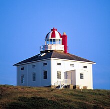
A lighthouse has operated at Cape Spear since September 1836. The original Cape Spear lighthouse was the second lighthouse built in Newfoundland; the first was built in 1810 at Fort Amherst, at the entrance to St. John's Harbour. In 1832, the first legislative assembly for the colony created a lighthouse board. Cape Spear was chosen as the site for a new lighthouse because it was on the rocky eastern coast near the entrance to St John's harbour.
Construction began in 1834. The first lighthouse was a square wooden building with a tower in the middle containing the light. A foghorn was added in 1878. The first light used at Cape Spear had already been used since 1815 at a lighthouse at Inchkeith on the east coast of Scotland. This light used seven Argand burners and curved reflectors. This was later replaced by a dioptric lens system; the light was first lit by oil, then acetylene and finally electricity in 1930.
Because of its proximity to convoy routes during the Second World War, a gun battery was installed at Cape Spear to defend the entrance to St. John's harbour. Barracks and underground passages leading to the bunkers were built for the use of troops stationed there.
Current
A new concrete building was built to house the light in 1955. The lighthouse is the oldest surviving lighthouse in Newfoundland and the location has been designated a Canadian National Historic Site. The original lighthouse building and the light keeper's residence have since been restored to the period of 1939, and are open to the public. The visitor centre includes a gift shop.
The World War II bunkers and gun barrels that located at the site afford a sheltered view of the ocean.
Some visitors attracted by the scenery and history have been swept away by the large and unpredictable waves at Cape Spear, prompting Parks Canada to post numerous warning signs in the area.
Cape Spear was also used for the filming of a hockey game in the Canadian television series, Road Hockey Rumble.
At 6:24am NST 3/10/2011 Duane Linklater watched the sunrise
Image gallery
-
The modern and the old lighthouses
-
The battery at Cape Spear
-
The cliffs around Cape Spear
References
- ^ The Canadian Encyclopedia — Cape Spear
Further reading
- Environment Canada – Parks, Cape Spear National Historic Park brochure, 1986.


