
Bonaire: Difference between revisions
Rearranged pictures |
Added info box |
||
| Line 1: | Line 1: | ||
{{otheruses}} |
{{otheruses}} |
||
{| style =" "margin-left:" 0.5em;" border="1" cellpadding="2" cellspacing="0" align="right" width="260px" |
|||
| ⚫ | |||
|+ <font size="+1">'''Bonaire'''</font> |
|||
[[Image:Bonaire_Location.png|thumb|right|Bonaire is an island in the [[Caribbean Sea]], off the coast of [[Venezuela]].]] |
|||
|- |
|||
| style="background:#efefef;" align="center" colspan=2 | |
|||
{| border="0" cellpadding="2" cellspacing="0" |
|||
|- |
|||
| ⚫ | |||
|- |
|||
|} |
|||
|- |
|||
| align="center" colspan=2 | <font size="-1">''Anthem: Tera di Solo y suave biento''</font> |
|||
|- |
|||
| align="center" colspan=2 | [[Image:Bonaire_Location.png|Location of Bonaire]] |
|||
|- |
|||
| [[Capital]] || [[Kralendijk]] |
|||
|- |
|||
| [[Area]]<br /> - Total <br /> - % water |
|||
| (Not ranked)<br /> 288 km² <br /> Negligible |
|||
|- |
|||
| [[Population]] |
|||
- Total |
|||
<br /> - [[Population density|Density]] |
|||
| |
|||
<br /> 10,185 (2004) |
|||
<br /> 35/km² |
|||
|} |
|||
[[Image:bonaire island.png|thumb|Bonaire Island and Klein Bonaire, from space, March 1996]] |
[[Image:bonaire island.png|thumb|Bonaire Island and Klein Bonaire, from space, March 1996]] |
||
| ⚫ | |||
'''Bonaire''' is an island in the [[Netherlands Antilles]], and as such, is a part of the [[Kingdom of the Netherlands]]. Together with [[Aruba]] and [[Curaçao]] it forms a group referred to as the [[ABC islands]]. While [[Papiamento]], [[English language|English]] and [[Spanish language|Spanish]] are commonly spoken, the official language is [[Dutch language|Dutch]]. |
'''Bonaire''' is an island in the [[Netherlands Antilles]], and as such, is a part of the [[Kingdom of the Netherlands]]. Together with [[Aruba]] and [[Curaçao]] it forms a group referred to as the [[ABC islands]]. While [[Papiamento]], [[English language|English]] and [[Spanish language|Spanish]] are commonly spoken, the official language is [[Dutch language|Dutch]]. |
||
| Line 47: | Line 71: | ||
==External links== |
==External links== |
||
{{Commons|Category:Bonaire|Bonaire}} |
{{Commons|Category:Bonaire|Bonaire}} |
||
| ⚫ | |||
*[http://www.gov.an/ www.gov.an] - official governmental portal of the Netherlands Antilles |
*[http://www.gov.an/ www.gov.an] - official governmental portal of the Netherlands Antilles |
||
**[http://www.bonaire-gov.an/ Bonaire-gov.an] - official website of the government of Bonaire |
**[http://www.bonaire-gov.an/ Bonaire-gov.an] - official website of the government of Bonaire |
||
| Line 56: | Line 79: | ||
*[http://www.greatcaribbeanadventures.com/bonaire/index.asp Caribbean Adventures - Bonaire] |
*[http://www.greatcaribbeanadventures.com/bonaire/index.asp Caribbean Adventures - Bonaire] |
||
*[http://www.diveintoadventurebonaire.com/ DiveIntoAdventureBonaire.com] - official web site of the island-wide Dive Into Adventure Bonaire event June 17-24, 2006 |
*[http://www.diveintoadventurebonaire.com/ DiveIntoAdventureBonaire.com] - official web site of the island-wide Dive Into Adventure Bonaire event June 17-24, 2006 |
||
<gallery> |
|||
| ⚫ | |||
| ⚫ | |||
</gallery> |
|||
{{maplr|12.16|-68.23|Bonaire}} |
{{maplr|12.16|-68.23|Bonaire}} |
||
Revision as of 23:28, 4 June 2006
| ||
| Anthem: Tera di Solo y suave biento | ||

| ||
| Capital | Kralendijk | |
| Area - Total - % water |
(Not ranked) 288 km² Negligible | |
| Population
- Total
|
| |


Bonaire is an island in the Netherlands Antilles, and as such, is a part of the Kingdom of the Netherlands. Together with Aruba and Curaçao it forms a group referred to as the ABC islands. While Papiamento, English and Spanish are commonly spoken, the official language is Dutch.
Bonaire has a land area of 288 km² (111 sq. miles). At the 2001 Netherlands Antilles census, the population was 10,791 inhabitants, which means a population density of 37 inh. per km². In 2004 the population was estimated at 10,185 inhabitants. Uninhabited Klein Bonaire, nestled in the western crescent of the main island, is 6 km² (2.3 sq. miles). Bonaire is served by Flamingo International Airport.
The structure of the relationship between Bonaire and the Kingdom is being considered for change under proposed legislation.
Cities/Towns
The only generally recognized towns on the island are Kralendijk and Rincon. Kralendijk has many suburbs/neighborhoods (on an island with such a small population, the distinction is not always clearcut). Kralendijk's suburbs/neighborhoods include:
- Antriol
- Belnem
- Hato
- Lagoen
- Lima
- Noord Salina
- Nikiboko
- Republiek
- Sabadeco
- Sabana
- Santa Barbara
- Tera Cora
Several smaller towns had existed in the national park, but are now abandoned. They were: Labra, Ishiri, Kokorobi, Jan Doran, Vlijt, Rigot, Porto Spano, and Kunchi.
Salt
Exploiting its natural topography, Bonaire has been a major supplier of salt to the USA for many years, and continues to do so through the flooding of flat-lands with sea water. Bonaire was originally settled by the Dutch in the late 15th century as a source of salt, using the same evaporative methods used today, albeit on a small scale. Much of the early population of the island was in the form of slaves used to work the salt ponds. Today the slave huts remain as a historical site, and are the names of two popular dive sites "Red-" and "White Slave Huts." Salt production today covers much of the southern half of the island, and is run by the industrial giant Cargill.
Diving and Other Natural Features

Bonaire is world renowned for its excellent scuba diving and is consistently rated among the top shore diving and Caribbean diving locations in the world. In fact, Bonaire's license plates carry the logo Diver's Paradise in English. The island is ringed by a coral reef that is easily accessible from the shore along the Western and Southern sides. Furthermore, the entire coastline of the island has been declared a marine sanctuary, preserving local fish life. Bonaire is also consistently recognized as one of the best destinations for snorkeling.
The coral reef around uninhabited Klein Bonaire is particularly well conserved, and it draws divers, snorkelers, and boaters.
In addition to its rich marine preserve, Bonaire is also famed for its flamingo populations and its donkey sanctuary.
Washington Slagbaai National Park, located at the north side of the island, is an ecological preserve. The highest point of Bonaire, Brandaris, located within this preserve has a complete view of the island.
Lac Bay on the eastern side of the island is a windsurfer's paradise. Locals Taty and Tonky Frans in 2004 were ranked in the top five of the world's freestyle windsurfing professionals.
External links
- www.gov.an - official governmental portal of the Netherlands Antilles
- Bonaire-gov.an - official website of the government of Bonaire
- BonaireEconomy.org - Department of Economic & Labour Affairs (DELA)
- InfoBonaire.com - Tourism Board of Bonaire
- Bonaire in Motion - Video tour of Bonaire by the Tourism Board
- Lonely Planet - Bonaire
- Caribbean Adventures - Bonaire
- DiveIntoAdventureBonaire.com - official web site of the island-wide Dive Into Adventure Bonaire event June 17-24, 2006
-
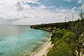 The coast of Bonaire is renowned for it's clear, coral-rich waters.
 -
 Banded coral shrimp resting under some Bonaire coral.


Template:Maplr Mapquest zoom level 7 only has the Kralendijk region; this region is also available in zoom level 8, 9, and 10.