Hunt's Island: Difference between revisions
Appearance
Content deleted Content added
Magnolia677 (talk | contribs) +category |
Djblackwood (talk | contribs) No edit summary |
||
| Line 52: | Line 52: | ||
}} |
}} |
||
'''Hunt's Island''' is an abandoned fishing settlement in the District of [[Burgeo-La Poile]], on the south west coast of [[Newfoundland]], Canada. It was settled in the 1830s and [[Resettlement (Newfoundland)|resettled]] in 1963.<ref>{{cite web|title=A look at the past - SaltWire|url=https://www.saltwire.com/atlantic-canada/holidays/a-look-at-the-past-47892/}}</ref><ref>{{cite web|title=Return to Hunt's Island|url=https://www.pressreader.com/canada/the-gulf-news-port-aux-basques/20160725/281741268779111}}</ref> In 1911, it had a population of 195. This declined to 175 in 1921, rebounded to 178 in 1935, and declined again to 132 in 1945.<ref>{{cite web|title=Hunt's Island, Newfoundland|url=https://www.familysearch.org/research/places/?focusedId=11027076}}</ref> Hunt's Island is located in census division 3, subdivision F.<ref name="SGC">{{Cite web|title=Standard Geographical Classification (SGC) 1996|url=https://www23.statcan.gc.ca/imdb/p3VD.pl?Function=getVD&TVD=135514&CVD=135517&CPV=1003024&CST=01011996&CLV=3&MLV=3}}</ref> |
'''Hunt's Island''' is an abandoned fishing settlement in the District of [[Burgeo-La Poile]], on the south west coast of [[Newfoundland]], Canada. It was settled in the 1830s and [[Resettlement (Newfoundland)|resettled]] in 1963.<ref>{{cite web|title=A look at the past - SaltWire|url=https://www.saltwire.com/atlantic-canada/holidays/a-look-at-the-past-47892/}}</ref><ref>{{cite web|title=Return to Hunt's Island|url=https://www.pressreader.com/canada/the-gulf-news-port-aux-basques/20160725/281741268779111}}</ref> In 1911, it had a population of 195. This declined to 175 in 1921, rebounded to 178 in 1935, and declined again to 132 in 1945.<ref>{{cite web|title=Hunt's Island, Newfoundland|url=https://www.familysearch.org/research/places/?focusedId=11027076}}</ref> Hunt's Island is located in [[Division No. 3, Subdivision F, Newfoundland and Labrador|census division 3, subdivision F]].<ref name="SGC">{{Cite web|title=Standard Geographical Classification (SGC) 1996|url=https://www23.statcan.gc.ca/imdb/p3VD.pl?Function=getVD&TVD=135514&CVD=135517&CPV=1003024&CST=01011996&CLV=3&MLV=3}}</ref> |
||
==See also== |
==See also== |
||
Revision as of 00:00, 23 August 2021
| Geography | |
|---|---|
| Coordinates | 47°35′58″N 57°36′41″W / 47.59944°N 57.61139°W |
| Administration | |
Canada | |
| Province | Newfoundland and Labrador |
| Census division | No. 3 |
| Subdivision | F |
| [1][2] | |
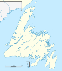
Hunt's Island is an abandoned fishing settlement in the District of Burgeo-La Poile, on the south west coast of Newfoundland, Canada. It was settled in the 1830s and resettled in 1963.[3][4] In 1911, it had a population of 195. This declined to 175 in 1921, rebounded to 178 in 1935, and declined again to 132 in 1945.[5] Hunt's Island is located in census division 3, subdivision F.[2]
See also
- List of communities in Newfoundland and Labrador
- List of ghost towns in Newfoundland and Labrador
- List of islands of Newfoundland and Labrador
- Burgeo-La Poile
References
- ^ "Hunt's Island". Natural Resources Canada. October 6, 2016.
- ^ a b "Standard Geographical Classification (SGC) 1996".
- ^ "A look at the past - SaltWire".
- ^ "Return to Hunt's Island".
- ^ "Hunt's Island, Newfoundland".

