
Woodberry, New South Wales: Difference between revisions
Content deleted Content added
mNo edit summary |
mNo edit summary |
||
| Line 2: | Line 2: | ||
<gallery> |
<gallery> |
||
Image:Woodberry.jpg|Looking West from 300m above the ground. Woodberry is logically divided into three main parts (although they are referred to as such to the locals): East Woodberry (foreground), Woodberry proper (mid-right), and South Woodberry (left). The small Woodberry shops and pub are between South Woodberry and Woodberry proper. Parts of Beresfield and Thornton are visible to the left and right of the lake at the top of the photo. |
Image:Woodberry.jpg|Looking West from 300m above the ground. Woodberry is logically divided into three main parts (although they are not referred to as such to the locals): East Woodberry (foreground), Woodberry proper (mid-right), and South Woodberry (left). The small Woodberry shops and pub are between South Woodberry and Woodberry proper. Parts of Beresfield and Thornton are visible to the left and right of the lake at the top of the photo. |
||
</gallery> |
</gallery> |
||
{{NewSouthWales-geo-stub}} |
{{NewSouthWales-geo-stub}} |
||
Revision as of 00:27, 18 February 2007
Woodberry is the eastern-most town of Maitland City, New South Wales, Australia. It adjoins Beresfield across the main northern railway line, which is the western-most town of Newcastle City. Along with Beresfield it has the postcode 2322.
-
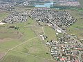 Looking West from 300m above the ground. Woodberry is logically divided into three main parts (although they are not referred to as such to the locals): East Woodberry (foreground), Woodberry proper (mid-right), and South Woodberry (left). The small Woodberry shops and pub are between South Woodberry and Woodberry proper. Parts of Beresfield and Thornton are visible to the left and right of the lake at the top of the photo.

This New South Wales geography article is a stub. You can help Wikipedia by expanding it. |