
Singelgracht: Difference between revisions
m clean up, typo(s) fixed: , → , |
various edits |
||
| Line 32: | Line 32: | ||
| west = |
| west = |
||
}} |
}} |
||
The '''Singelgracht''' ({{IPA-nl|ˈsɪŋəlˌɣrɑxt}}) is |
The '''Singelgracht''' ({{IPA-nl|ˈsɪŋəlˌɣrɑxt}}) is a semi-circular waterway that borders the entire city centre of [[Amsterdam]], the Netherlands. The canal runs along the {{ill|Nassaukade|nl|Nassaukade (Amsterdam)}}, {{ill|Stadhouderskade|nl|Stadhouderskade (Amsterdam)}} and {{ill|Mauritskade|nl|Mauritskade (Amsterdam)}} streets. |
||
Formerly |
Formerly part of the [[Rampart (fortification)|ramparts]], it formed the outer defenses of the city. |
||
==Name== |
==Name== |
||
| ⚫ | |||
| ⚫ | |||
The Singelgracht is often confused with another Amsterdam canal, the [[Singel]]. The Singel however surrounds the relatively small medieval center of Amsterdam, whereas the Singelgracht surrounds the entire city center, including the famous [[Canals of Amsterdam|ring of canals]]. The name merely applies to the waterway, not to the adjacent built-up quays. The names of the streets on the 'inside' of the semi-circular canal are: Marnixkade, Leidsekade, Nicolaas Witsenkade, Sarphatikade, Huddekade, Spinozastraat and Alexanderkade. On the 'outside' are three major roads: Nassaukade (west), Stadhouderskade (south) and Mauritskade (east). Singelgracht therefore is never part of an address. For this reason the name is less known than that of other canals. |
|||
| ⚫ | |||
| ⚫ | |||
==History |
==History== |
||
After the fourth expansion of the Amsterdam canal ring around 1660, the outer canal – with the ramparts that formed the city defenses – became the new boundary of the city. Within these ramparts there were strongholds on which windmills were built. As a result, the canal had a much more curvier course than these days. Parallel to the Singelgracht, on the inside of the ramparts was the [[Lijnbaansgracht]] situated, named after the [[Ropewalk|ropeyards]] in this area. |
|||
For two centuries, Amsterdam kept its characteristic crescent-shaped layout. In the last quarter of the 19th century, the city expanded beyond the Singelgracht. New roads were layed out on the former ramparts: [[Marnixstraat]], Weteringschans and Sarphatistraat. Most of the strongholds or [[Bastion|bulwarks]] (Dutch: "bolwerken") were demolished and the canal was straightened. The former winding course can still be recognized in a few places. Two windmills remain; both however were moved to new locations: ''De Gooyer'' to Zeeburgerstraat in [[Amsterdam-Oost]] and ''De Bloem'' to Haarlemmerweg in [[Amsterdam-West]]. |
|||
After the fourth expansion of the canal ring around 1660, the outer canal – with the ramparts that formed the defenses – became the boundary of the city. |
|||
Within these ramparts there were strongholds on which mills were placed. |
|||
As a result, the canal had a curvy course. |
|||
Parallel to the Singelgracht, on the inside of the ramparts lay the [[Lijnbaansgracht]], named after the lanes that lay there. |
|||
Parts of the strongholds were demolished and the canal was straightened there. |
|||
The old winding course can still be recognized in a few places. |
|||
Of the mills on the strongholds, two remain, both moved to new locations: De Gooyerat to the Zeeburgerstraat in Amsterdam-Oost and De Bloem to the Haarlemmerweg. |
|||
For two centuries, Amsterdam had a characteristic crescent-shaped layout. |
|||
In the last quarter of the 19th century, Amsterdam expanded beyond the Singelgracht. |
|||
The ramparts were demolished and [[Marnixstraat]], Weteringschans and Sarphatistraat were developed. |
|||
==Bridges== |
==Bridges== |
||
The section of the Singelgracht between the [[Westerkanaal]] and the Rotterdammerbrug is part of the shipping connection (standing mast route) between the IJ and the Kattensloot / Kostverlorenvaart, with movable bridges on either side of the Willemspoort . |
The section of the Singelgracht between the [[Westerkanaal]] and the Rotterdammerbrug is part of the shipping connection (standing mast route) between the IJ and the Kattensloot / Kostverlorenvaart, with movable bridges on either side of the Willemspoort . |
||
The other bridges over the Singelgracht are fixed bridges. |
The other bridges over the Singelgracht are fixed bridges. |
||
==Confusion with the Singel == |
|||
The Amsterdam Singelgracht is often confused with the [[Singel]]. |
|||
The canal called the Singel forms the border of the medieval city center parallel to the Herengracht. |
|||
The Singelgracht is the waterway that borders the entire Center. |
|||
The name only indicates the canal, not the adjacent built-up quays. |
|||
Partly for this reason the name is less known than that of other canals. |
|||
On the outside of the canal are the Nassaukade (west), Stadhouderskade (south) and Mauritskade (east); on the center side the Marnixkade, Leidsekade, Nicolaas Witsenkade, Sarphatikade, Huddekade, Spinozastraat and Alexanderkade. |
|||
==Gallery== |
==Gallery== |
||
<gallery mode=packed heights=180> |
<gallery mode=packed heights=180> |
||
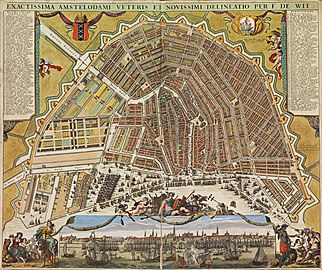
File:Exact Drawing of Old and New Amsterdam (Map) 1699-1706 by Frederik de Wit.jpg| |
File:Exact Drawing of Old and New Amsterdam (Map) 1699-1706 by Frederik de Wit.jpg|Singelgracht on an upside-down map of c. 1700 (curvy canal along the ramparts) |
||
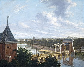
File:Johannes Jelgerhuis - De Amsterdamse buitensingel bij de Leidse poort.jpg|Painting from 1816 by [[Johannes Jelgerhuis]], showing |
File:Johannes Jelgerhuis - De Amsterdamse buitensingel bij de Leidse poort.jpg|Painting from 1816 by [[Johannes Jelgerhuis]], showing Singelgracht near [[Leidsepoort]] |
||
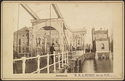
File:Ophaalbrug met op de achtergrond de Stadsschouwburg - Amsterdam - 20329118 - RCE.jpg| |
File:Ophaalbrug met op de achtergrond de Stadsschouwburg - Amsterdam - 20329118 - RCE.jpg|Drawbridge over Singelgracht at Leidsebosje with the old [[Stadsschouwburg]] theater in the background |
||
| ⚫ | |||
File:Muiderpoort amsterdam 3.jpg| |
File:Muiderpoort amsterdam 3.jpg|[[Muiderpoort]] as seen from Singelgracht |
||
| ⚫ | |||
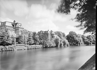
File:Villa's Weteringschans in Amsterdam 2011.jpg| |
File:Villa's Weteringschans in Amsterdam 2011.jpg|Late 19th-century villas along Weteringschans opposite [[Rijksmuseum]], here seen from Singelgracht |
||
File:Raampoort foto 2.jpg|Raampoort police station |
File:Raampoort foto 2.jpg|Raampoort police station, Marnixstraat 148, here seen from Singelgracht |
||
File:Overzicht spoorbrug over de Houtmankade - Amsterdam - 20536563 - RCE.jpg| |
File:Overzicht spoorbrug over de Houtmankade - Amsterdam - 20536563 - RCE.jpg|Railway bridge over Singelgracht between [[Amsterdam Centraal station|Central Station]] and [[Amsterdam Sloterdijk station|Sloterdijk station]] |
||
</gallery> |
</gallery> |
||
Revision as of 11:53, 24 April 2024
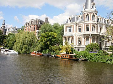
 The Singelgracht at the Stadhouderskade, Holland Casino on the left | |
 The Singelgracht surrounds the protected cityscape, indicated in a lighter shade, to the west, south and east. | |
| Location | Amsterdam |
|---|---|
| Postal code | 1015, 1016, 1017, 1018 |
| Coordinates | 52°23′03″N 4°52′54″E / 52.384122°N 4.881703°E |
| East end | IJ |
| To | Eastern Port Area |
| Construction | |
| Construction start | 17th century |
The Singelgracht (Dutch pronunciation: [ˈsɪŋəlˌɣrɑxt]) is a semi-circular waterway that borders the entire city centre of Amsterdam, the Netherlands. The canal runs along the Nassaukade, Stadhouderskade and Mauritskade streets. Formerly part of the ramparts, it formed the outer defenses of the city.
Name
The name is related to the Dutch word omsingelen, "to surround", and comes ultimately from Latin cingulum, meaning "belt". "Gracht" means canal. Other Dutch towns also have ring-shaped canals named Singel or Singelgracht.
The Singelgracht is often confused with another Amsterdam canal, the Singel. The Singel however surrounds the relatively small medieval center of Amsterdam, whereas the Singelgracht surrounds the entire city center, including the famous ring of canals. The name merely applies to the waterway, not to the adjacent built-up quays. The names of the streets on the 'inside' of the semi-circular canal are: Marnixkade, Leidsekade, Nicolaas Witsenkade, Sarphatikade, Huddekade, Spinozastraat and Alexanderkade. On the 'outside' are three major roads: Nassaukade (west), Stadhouderskade (south) and Mauritskade (east). Singelgracht therefore is never part of an address. For this reason the name is less known than that of other canals.
History
After the fourth expansion of the Amsterdam canal ring around 1660, the outer canal – with the ramparts that formed the city defenses – became the new boundary of the city. Within these ramparts there were strongholds on which windmills were built. As a result, the canal had a much more curvier course than these days. Parallel to the Singelgracht, on the inside of the ramparts was the Lijnbaansgracht situated, named after the ropeyards in this area.
For two centuries, Amsterdam kept its characteristic crescent-shaped layout. In the last quarter of the 19th century, the city expanded beyond the Singelgracht. New roads were layed out on the former ramparts: Marnixstraat, Weteringschans and Sarphatistraat. Most of the strongholds or bulwarks (Dutch: "bolwerken") were demolished and the canal was straightened. The former winding course can still be recognized in a few places. Two windmills remain; both however were moved to new locations: De Gooyer to Zeeburgerstraat in Amsterdam-Oost and De Bloem to Haarlemmerweg in Amsterdam-West.
Bridges
The section of the Singelgracht between the Westerkanaal and the Rotterdammerbrug is part of the shipping connection (standing mast route) between the IJ and the Kattensloot / Kostverlorenvaart, with movable bridges on either side of the Willemspoort . The other bridges over the Singelgracht are fixed bridges.
Gallery
-
 Singelgracht on an upside-down map of c. 1700 (curvy canal along the ramparts)
 -
 Painting from 1816 by Johannes Jelgerhuis, showing Singelgracht near Leidsepoort
 -
 Drawbridge over Singelgracht at Leidsebosje with the old Stadsschouwburg theater in the background
 -
 Demolished villas along Singelgracht, in the 1960s replaced by office buildings ("salt & pepper dispensers")
 -
 Muiderpoort as seen from Singelgracht
 -
 Late 19th-century villas along Weteringschans opposite Rijksmuseum, here seen from Singelgracht
 -
 Raampoort police station, Marnixstraat 148, here seen from Singelgracht
 -
 Railway bridge over Singelgracht between Central Station and Sloterdijk station
_1699-1706_by_Frederik_de_Wit.jpg)


See also
References
External links
- De bocht in de Singelgracht - amsterdamsebinnenstad.nl
- Bolwerken van Amsterdam - centrum.amsterdam.nl
- De laatste stadswal van Amsterdam - ernestkurpershoek.nl
- De ommuurde stad - lubberhuizen.nl
Excludes former canals that have since been filled in | ||
| Amstel sections | .jpg) | |
| Inner City | ||
| Lastage | ||
| Grachtengordel | ||
| Jordaan | ||
| Plantage | ||
| Westelijke Eilanden | ||
| Oostelijke Eilanden | ||