The Banks, Cincinnati: Difference between revisions
Lanskeith17 (talk | contribs) No edit summary |
Lanskeith17 (talk | contribs) |
||
| Line 15: | Line 15: | ||
[[Image:Gabp from the gap.jpg|thumb|200px|right|Great American Ballpark]] |
[[Image:Gabp from the gap.jpg|thumb|200px|right|Great American Ballpark]] |
||
[[Image:Cincinnati-paul-brown-stadium.jpg|thumb|200px|right|Paul Brown Stadium]] |
[[Image:Cincinnati-paul-brown-stadium.jpg|thumb|200px|right|Paul Brown Stadium]] |
||
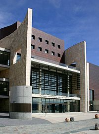
[[Image:National underground railroad freedom center main entrance 2006.jpg|thumb|200px|right|National Underground Railroad Freedom Center |
[[Image:National underground railroad freedom center main entrance 2006.jpg|thumb|200px|right|National Underground Railroad Freedom Center]] |
||
[[Image:Cincinnati-us-bank-arena.jpg|thumb|200px|right|U.S. Bank Arena]] |
[[Image:Cincinnati-us-bank-arena.jpg|thumb|200px|right|U.S. Bank Arena]] |
||
#Four Anchor Attractions: |
#Four Anchor Attractions: |
||
Revision as of 14:57, 14 June 2007

"The Banks" is the name given to current mixed use project and development for the land between the Paul Brown Stadium and the Great American Ballpark along the Ohio River in Cincinnati Ohio.[1]
Riverfront Master Plan
The Cincinnati Central Riverfront Master Plan is the result of a public participation planning process begun in October 1996. Hamilton County and the City of Cincinnati engaged Urban Design Associates to prepare a plan to give direction in two public policy areas: 1) to site the two new stadiums for the Cincinnati Reds and the Cincinnati Bengals, and 2) to develop an overall urban design framework for the development of the central riverfront which would capitalize on the major public investment in the stadiums and structured parking.
A Riverfront Steering Committee made up of City and County elected officials and staff was formed as a joint policy board for the Central Riverfront Plan. Focus groups, interviews, and public meetings were held throughout the planning process.
A Concept Plan was published in April 1997 which identified three possible scenarios for the siting of the stadiums and the development of the riverfront. The preparation of a final Master Plan was delayed due to a November 1998 public referendum on the siting of the Reds Stadium.
Once the decision on the Reds Stadium was made by the voters in favor of a riverfront site, Hamilton County and the City of Cincinnati appointed sixteen prominent citizens to the Riverfront Advisors Commission who were charged to "recommend mixed usage for the Riverfront that guarantees public investment will create sustainable development on the site most valued by our community". The result of that effort was The Banks, a September 1999 report from the Advisors which contained recommendations on land use, parking, finance, phasing, and developer selection for the Central Riverfront. The final Master Plan includes The Banks recommendations from the Advisors.[2]
Major Elements


- Four Anchor Attractions:
- New Attractions: Great American Ballpark, Paul Brown Stadium, National Underground Railroad Freedom Center
- Existing Attraction: U.S. Bank Arena
- Parking for over 6000 cars
- The Banks mixed-used district with: 900 to 1300 housing units; 400,000 to 500,000 sq. feet of retail and entertainmen, 100,000 to 200,000 sq. feet of offices, and a hotel of 200 to 400 rooms.
- A new, 70-acre riverfront park serving as a front door to the city as well as a location for major festivals
- A narrowed, redesigned, and partially decked Fort Washington Way, the sunken interstate highway which runs east-west through the City in between Downtown and the Riverfront
- An Intermodal Transit Center below grade on the south side of Fort Washington Way for buses, service, future on-grade light rail, and future commuter rail.
- A redeveloped Third Street with new commercial office buildings and supporting retail and parking[[3]]
Transportation
Cincinnati and Hamilton County support the regional development of light rail transit linking the airport, Northern Kentucky, the Central Riverfront, Downtown Cincinnati, and the University of Cincinnati by way of split tracks on eastbound Second Street and westbound Third Street.[4]
Completed Projects
- Paul Brown Stadium
- Redesigned Fort Washington Way and the Intermodal Transportation Center
- Great American Ballpark
- National Underground Railroad Freedom Center
Current Projects
External Links
- The Cincinnati Central Riverfront Master Plan
- Banks Theme Page @ Cincinnati Enquirer
- Cincinnati Riverfront Park
