
Table Rock Wilderness: Difference between revisions
add references and more information |
m added two images |
||
| Line 19: | Line 19: | ||
Like ''Table Rock'', there are five listed locations in Oregon named ''Rooster Rock''.</ref> |
Like ''Table Rock'', there are five listed locations in Oregon named ''Rooster Rock''.</ref> |
||
The rock slide on the north facing side of Table Rock is surrounded by a profusion of Salmonberry and is well populated with a large colony of [[Pika]]s, a small alpine rodent. |
The rock slide on the north facing side of Table Rock is surrounded by a profusion of Salmonberry and is well populated with a large colony of [[Pika]]s, a small alpine rodent. |
||
<gallery> |
|||
Image:Tablerock rockfield.JPG|Rock field beneath Table Rock |
|||
Image:Tablerock basalt.JPG|Table Rock from below |
|||
</gallery> |
|||
<div class="references-small" {{#if: {{{colwidth|}}}| style="-moz-column-width:{{{colwidth}}}; column-width:{{{colwidth}}};" | {{#if: {{{1|}}}| style="-moz-column-count:{{{1}}}; column-count:{{{1}}} }}};" |}}> |
<div class="references-small" {{#if: {{{colwidth|}}}| style="-moz-column-width:{{{colwidth}}}; column-width:{{{colwidth}}};" | {{#if: {{{1|}}}| style="-moz-column-count:{{{1}}}; column-count:{{{1}}} }}};" |}}> |
||
Revision as of 00:52, 24 July 2007
The Table Rock Wilderness is a small pocket wilderness designated in 1984[1] in the western Cascade Mountains in the northwestern portion of Oregon, United States. The wilderness area protects 5,500 acres (8.6 mi², 22 km²) of mature timber in the Molalla River drainage basin, some 19 miles southeast of Molalla, Oregon and 50 miles southeast of Portland. Despite its small size, the wilderness spans Clackamas and Marion counties. Somewhat unusual for a wilderness in this area is that it is on BLM land instead of nearby Mount Hood National Forest.[1]
The wilderness is in the densely forested and lower western Cascades, with the highest point being the namesake Table Rock[2] which rises 4,881 feet above sea level.[3]
There are four trailheads to the area.[1] The main trail, Table Rock Trail, is the same path used by native Americans and was part of the larger cross-Cascades trail system. Site of archeological interest can be found here, including a petroglyph rock.[4] A moderately difficult hiking trail climbs 3.6 miles to the summit of Table Rock where the western Cascades can be viewed. The panorama stretches from Mount Rainer in the north to Mount Shasta a mere speck in the distance, in California. There is a dense network of hiking trails. Relative solitude can be expected due to the Forest Service reporting approximately 900 annual visitors.
The higher trails are snow covered from November to May, though usually clear by Memorial Day. Typical low elevation flora such as Douglas-fir and Western Hemlock pervade the slopes, while Rhododendrons blossom in abundance in the month of June. By August Huckleberry and Salmonberry ripen on the slopes of Table and Rooster Rock.[5] The rock slide on the north facing side of Table Rock is surrounded by a profusion of Salmonberry and is well populated with a large colony of Pikas, a small alpine rodent.
-
 Rock field beneath Table Rock
 -
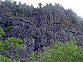 Table Rock from below


- ^ a b c "Table Rock Wilderness". wilderness.net. Retrieved 2007-02-15.
- ^ There are eight distinct points in Oregon named Table Rock according to the U.S. Board on Geographic Names database.
- ^ Sources disagree on the elevation of the summit. US Board of Geographic Names gives 4,810 feet; Wilderness.net gives 4,881 feet; TopoZone gives 1488 m (4,882 feet).
- ^ "Oregon's Historic Trails: Klamath Trail, 19th Century". Oregon Historic Trails Fund. Retrieved 2007-02-15.
- ^ Like Table Rock, there are five listed locations in Oregon named Rooster Rock.
External links
Table Rock Wilderness
This is the the wilderness reference point according to the USGS Template:Geolinks-US-mountain