Mormon corridor: Difference between revisions
→See also: Removing barely related link. Better served by categories and portals. |
|||
| Line 49: | Line 49: | ||
{{portal|Latter-day Saints|Christus statue temple square salt lake city.jpg| 40}} |
{{portal|Latter-day Saints|Christus statue temple square salt lake city.jpg| 40}} |
||
*[[Jell-O Belt]] |
*[[Jell-O Belt]] |
||
*[[Mission field]] |
|||
*[[Mormon colonies in Mexico]] |
*[[Mormon colonies in Mexico]] |
||
*[[Mormon]] |
*[[Mormon]] |
||
Revision as of 06:04, 28 February 2008

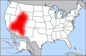
The Mormon Corridor is a term for the areas of Utah south of the Wasatch Front that were settled between 1850 and approximately 1865 by members of The Church of Jesus Christ of Latter-day Saints. Stretching from St. George in the southwest to Nephi in the northeast and including the Sevier River valley, the corridor is roughly congruent with the area between present-day Interstate 15 and U.S. Highway 89. Most of the population of the state that is not along the Wasatch Front or in Utah's Cache Valley resides in this corridor.
The term is also used to refer to the chain of Mormon settlements, ranging from Canada to Mexico, which could have provided support for a second migration of the Latter-day Saints which might have become necessary due to pressure by the U.S. government, starting with the Utah War. They also were waystations for migration and trade centered on Salt Lake City during the mid- to late 19th century. Some of these settlements were associated with existing or prior towns, and many were abandoned once the threat of persecution decreased after the 1890 Manifesto, and the transportation system in the Western United States matured.
Major cities and towns in Utah
|
|
Major cities and towns outside of Utah
|
|
