Pemberton, Western Australia: Difference between revisions
No edit summary |
Add link |
||
| Line 23: | Line 23: | ||
}} |
}} |
||
'''Pemberton''' is a town located in the [[Southwest, Western Australia|South West]] region of [[Western Australia]], named after the early settler Pemberton Walcott. It is the home of the [[karri]] tree, the largest tree in Western Australia and the third largest hardwood tree in the world. |
'''Pemberton''' is a town located in the [[Southwest, Western Australia|South West]] region of [[Western Australia]], named after the early settler Pemberton Walcott. It is the home of the [[karri]] tree, the largest tree in Western Australia and the third largest [[hardwood]] tree in the world. |
||
==History== |
==History== |
||
Revision as of 00:13, 4 May 2008
| Pemberton Western Australia | |||||||||
|---|---|---|---|---|---|---|---|---|---|
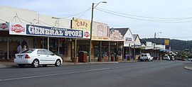
 Pemberton main street. | |||||||||
| Population | 757[1] | ||||||||
| Postcode(s) | 6260 | ||||||||
| Elevation | 174 m (571 ft)[2] | ||||||||
| LGA(s) | Shire of Manjimup | ||||||||
| State electorate(s) | Warren-Blackwood | ||||||||
| Federal division(s) | Forrest | ||||||||
| |||||||||
Pemberton is a town located in the South West region of Western Australia, named after the early settler Pemberton Walcott. It is the home of the karri tree, the largest tree in Western Australia and the third largest hardwood tree in the world.
History

Pemberton was originally occupied by the Bibbulmun Australian Aboriginal tribe until white explorers settled the area in the 1880s. The timber industry was established in 1912 and the town grew. Free land was offered to group settlers during the 1920s, however life was tough as clearing the land proved difficult.
Timber remained the primary industry, however dairy and crops such as potato, cauliflower and hops were developed. During the 1980s Pemberton started to grow as a tourist town. Tourism now plays an important role after old growth logging was drastically reduced by the state government in 2003. Rather than shutting down, the Pemberton Mills have switched to plantation blue gum and pine in addition to karri. Viticulture is now widely established with many investment schemes buying up large areas of pastureland and converting to vineyards.
Tourist attractions and events
The nearby Gloucester National Park contains three climbable karri trees, each in excess of 60 metres tall. The most famous is the Gloucester Tree, but there is also the Diamond Tree and the Dave Evans Bicentennial Tree, which is the tallest of the three and stands at around 71 metres. Each of these trees has been fitted with metal rungs which allow visitors to climb these trees and reach the constructed lookout at the top.

Other tourist attractions include the Pemberton Tramway Company and the Bibbulmun Track. Tours include river cruises, hiking, canoeing and four wheeled drive tours of the national parks surrounding the town.
The town's annual festival is the marron and wine festival held on the Australia Day weekend in January until 2008, when it was moved to May.[3] Pemberton is recognised as one of the premier cool climate wine regions in Australia, and hosts many wineries in the region.
In May 2005, in its launch issue the magazine Australian Traveller voted Pemberton as Australia's third worst town.[4] This caused public outcry from Western Australians many of which choose Pemberton as their favourite tourist destination. Pemberton has been showcased on many travel shows as being a number 1 nature destination in Australia. It is surrounded by karri forest with five national parks within 20 minutes drive from town and has plenty of rivers, streams and dams for recreation.
References
- ^ Australian Bureau of Statistics (25 October 2007). "Pemberton (L) (Urban Centre/Locality)". 2006 Census QuickStats. Retrieved 2008-01-15.
- ^ "Bureau of Meteorology: Pemberton Summary Statistics". Retrieved 2008-01-15.
- ^ "Marron Wine Festival". Retrieved 2008-01-15.
- ^ "Australian Travel: Flee It". Retrieved 2007-12-03.
