
Saintfield: Difference between revisions
No edit summary |
No edit summary |
||
| Line 123: | Line 123: | ||
* ''Saintfield Heritage'' - a publication of the [http://www.saintfieldtown.co.uk/heritage.htm Saintfield Heritage Society]. Books 1 - 7. Book 7 ISBN 0 9508620 6 1 |
* ''Saintfield Heritage'' - a publication of the [http://www.saintfieldtown.co.uk/heritage.htm Saintfield Heritage Society]. Books 1 - 7. Book 7 ISBN 0 9508620 6 1 |
||
[[Category: |
[[Category:Towns in County Down]] |
||
[[Category:Windmills in Northern Ireland]] |
[[Category:Windmills in Northern Ireland]] |
||
Revision as of 22:39, 11 October 2008
Saintfield
| |
|---|---|
 Saintfield Windmill | |
| Population | Expression error: "2,671 (2001 Census)" must be numeric |
| District | |
| County | |
| Country | Northern Ireland |
| Sovereign state | United Kingdom |
| Post town | BALLYNAHINCH |
| Postcode district | BT24 |
| Dialling code | 02897 |
| Police | Northern Ireland |
| Fire | Northern Ireland |
| Ambulance | Northern Ireland |
| UK Parliament | |
| NI Assembly | |
Saintfield (in Irish: Tamhnach Naomh, ie Field of Saints) is a market town located in mid-County Down, Northern Ireland, situated roughly halfway between Belfast and Downpatrick on the A7 road. Running east to west across the A7 is the B6 road and to the west of this crossroads is Main Street, which takes one towards Lisburn and Ballynahinch, and to the east is Station Road which takes one towards Killyleagh. It had a population of 2,959 people in the 2001 Census.
History
- Saintfield was originally an early 17th century settlement, from which the parish church survives. The present village form of Saintfield dates back to the early 18th century and the establishment of linen manufacturing and other trades by the Price family. The village had a number of corn, flour and flax mills, the remains of which are visible today, and has retained a tradition of textile manufacture through Saintfield Yarns. The architectural and historic significance of its village centre is reflected in its designation as a Conservation Area in 1997.
- Saintfield is probably most famous for the battle that took place there in June 1798, between the United Irishmen and the York fencibles and local yeomanry during the Irish rebellion. The headstones of men who were killed in this battle can be seen near the river at the bottom of the 1st Presbyterian Church graveyard, however the actual graves and bodies have been built over with new housing.
- 1798 graves
-
 Gravestone of James McEwen, United Irishman 1798
 -
 Plaque relating to graves of United Irishmen 1798
 -
 Gravestone of John Lowry, United Irishman 1798


Demographics
Saintfield is classified as an intermediate settlement by the NI Statistics and Research Agency (NISRA) (ie with population between 2,250 and 4,500 people). On Census day (29 April 2001) there were 2,959 people living in Saintfield. Of these:
- 25.6% were aged under 16 years and 16.3% were aged 60 and over
- 47.8% of the population were male and 52.2% were female
- 23.8% were from a Catholic background and 71.4% were from a Protestant background
- 1.9% of people aged 16-74 were unemployed.
For more details see: NI Neighbourhood Information Service
- In 1837 the population of Saintfield area was 7,154 of whom 1,053 lived in the town [1].
Places of interest
- The Rowallane Garden is situated just outside the village. The exotic gardens were started over 100 years ago, and are now in the care of the National Trust.
- Many of the buildings on the main street have old stables and courtyards behind them.
- The old White Horse Inn also sits on the main street.
From Lewis Topographical Dictionary (1837): The proprietor and lord of the manor, N. Price, Esq., improved the town in 1802, when he erected a large market-house and hotel, since which time Saintfield has been rapidly improving, and is now one of the most flourishing towns in the county.
- The Market House (now an Orange Hall) and the Hotel (now a private house) can be seen on Main Street.
-
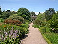 The walled garden at Rowallane
 -
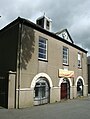 Saintfield Market House (1802)
 -
 2nd Presbyterian Hall (1954)
 -
 Guildhall
 -

-


Religion
- Churches
-
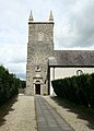
 1st Presbyterian Church (1777)
 -
 2nd Presbyterian Church
 -
 Baptist Church
 -
 Church of Ireland (listed building)
 -
 Roman Catholic Church


People

- Thomas Beattie MP, Member of the Canadian House of Commons, born in Saintfield
- Lord Faulkner, Prime Minister of Northern Ireland, died in a hunting accident near Saintfield
- Francis Hutcheson, philosopher & teacher born at Drumalig
- William David Kenny VC, awarded the Victoria Cross, born in Saintfield
- Bishop Daniel Mageean, Bishop of Down & Connor, born at Darragh Cross
- Rev. Coslett Herbert Waddell, Vicar of Saintfield, botanist
Education
Primary
- Academy Primary School
- Ballycloughan Primary School
- Darragh Cross Primary School
- Millennium Integrated Primary
- St. Mary's Primary School
Secondary
Sport
- Fishing at Carrickmannon Lake
- Saintfield AYC Football Club
- Saintfield Bowling Club
- Saintfield Cricket Club [2]
- Saintfield Hockey Club [3]
- Saintfield United Football Club
Transport
- Saintfield railway station opened on 10 September 1858 and finally closed on 16 January 1950.[4]
See also
- List of villages in Northern Ireland
- List of towns in Northern Ireland
- List of Primary schools in Northern Ireland
- Market Houses in Northern Ireland
External links
- Saintfield website
- First Saintfield Presbyterian Church
- Francis Hutcheson at The Online Library of Liberty
- Saintfield United F.C.
- Saintfield Antiques and Fine Books
References
- ^ Entry for Saintfield in Lewis Topographical Dictionary of Ireland (1837)
- ^ Saintfield Cricket Club
- ^ Saintfield Hockey Club
- ^ "Saintfield station" (PDF). Railscot - Irish Railways. Retrieved 2007-11-24.
- Culture Northern Ireland
- Saintfield Heritage - a publication of the Saintfield Heritage Society. Books 1 - 7. Book 7 ISBN 0 9508620 6 1