
Metropolitan Borough of Shoreditch: Difference between revisions
Lightmouse (talk | contribs) Units/dates/other using AWB |
Bethmenzies (talk | contribs) m →External links: ~~~~ Adding link to Shoreditch Town Hall virtual tours |
||
| Line 81: | Line 81: | ||
==External links== |
==External links== |
||
*[http://www.shoreditchtownhall.org.uk/ Shoreditch Town Hall Trust] |
*[http://www.shoreditchtownhall.org.uk/ Shoreditch Town Hall Trust] |
||
*[http://www.eyerevolution.co.uk/virtual_tours/shoreditch_town_hall/index.php Shoreditch Town Hall virtual tours] |
|||
==References== |
==References== |
||
Revision as of 13:30, 14 November 2008
| Shoreditch | |
|---|---|
 Shoreditch shown within the County of London | |
| Area | |
| • 1911/1931 | 658 acres (2.66 km2) |
| • 1961 | 659 acres (2.67 km2) |
| Population | |
| • 1911 | 111,390 |
| • 1931 | 97,042 |
| • 1961 | 40,455 |
| Density | |
| • 1911 | 169/acre |
| • 1931 | 147/acre |
| • 1961 | 61/acre |
| History | |
| • Origin | Shoreditch and Norton Folgate |
| • Created | 1900 |
| • Abolished | 1965 |
| • Succeeded by | London Borough of Hackney |
| Status | Metropolitan borough |
| Government | Shoreditch Borough Council |
| • HQ | Old Street |
| • Motto | More Light, More Power |
 Coat of arms adopted by the borough council | |
The Metropolitan Borough of Shoreditch was a metropolitan borough of the County of London between 1900 and 1965, when it was merged with the Metropolitan Borough of Stoke Newington and the Metropolitan Borough of Hackney to form the London Borough of Hackney.
The borough was made up of three main districts: Shoreditch, Hoxton and Haggerston. An individual coat of arms was never granted to the metropolitan borough council; they adopted the arms of the second lord of the manor of Shoreditch, John de Northampton.
Boundaries
The borough comprised the area of the ancient parish of Shoreditch (St Leonard's) plus part of the ancient liberty of Norton Folgate to the south [1] The parish vestry had taken on local administration from the 17th century onwards.
Town Hall
The civic buildings of the borough included the Town Hall (originally the Vestry Hall) in Old Street with the Magistrates Court (derelict in 2007), the Coroner's Court in Boundary St and other civic offices nearby.
The original Vestry Hall of 1866 was described at the time as the 'grandest in London' and was designed by Caesar Augustus Long, a local architect about whom little is known. On the abolition of the London Vestries it became the town hall and was extended and enlarged in 1902 and 1938. The building is embellished with symbolic statuary alluding to the borough motto: "More Light, More Power". As the 1902 extensions were being completed the building caught fire and substantial rebuilding was needed. Surplus to requirements following the abolition of Shoreditch Borough in 1965 it fell into increasing disuse and was leased to a charitable Trust in 1998 who carried out a £3.5m restoration and now run it as a self-sustaining community business.
The borough motto commemorates the provision of electric power to the borough from the Vestry of St Leonard Shoreditch Electric Light Station[2] later known as the Shoreditch Borough Refuse Destructor and Generating Station[3] on Coronet Street. This building is embellished with the motto E PULVERE LUX ET VIS (Out of the dust, light and power). It was built in 1895 and burned rubbish, to provide steam for the electricity generator. The waste heat was used to heat the public baths next door ( and now demolished). The building is now home to The Circus Space
Area and population
The metropolitan borough was conterminous with the Vestry authority, when it was formed in 1900. Statistics compiled by the London County Council, in 1901 show the population growth in London, over the preceding century.
The area of the borough in 1901 was 658 acres (2.7 km2). The populations recorded in National Censuses were:
Shoreditch St Leonard's Vestry 1801-1899
| Year[4] | 1801 | 1811 | 1821 | 1831 | 1841 | 1851 | 1861 | 1871 | 1881 | 1891 |
|---|---|---|---|---|---|---|---|---|---|---|
| Population | 34,766 | 43,930 | 52,966 | 68,564 | 83,432 | 109,257 | 129,364 | 127,164 | 126,591 | 124,009 |
Metropolitan Borough 1900-1961
| Year[5] | 1901 | 1911 | 1921 | 1931 | 1941 | 1951 | 1961 |
|---|---|---|---|---|---|---|---|
| Population | 118,668 | 111,390 | 104,248 | 104,248 | [6] | 44,871 | 40,455 |
By comparison, after amalgamation with Hackney and Stoke Newington, to form the modern London Borough of Hackney, the combined area became 19.06 km² - approximately 4,710 acres (19.1 km2); in 2005, this had a population of 207,700,[7] or a population density of 10,900/km². In 1901 Shoreditch the population density was 44,600/km².
Gallery
-
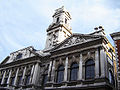 The impressive façade of Shoreditch Town Hall, now operated by a community run trust. (Sept 2005)
 -
 Detail of the town hall facade. Note that the imposing figure representing Progress carries an axe to clear the way to the future. (September 2005)


See also
External links
References
- ^ [1]
- ^ R. Crosley, London's coats of arms and the stories they tell (Robert Scott, London, 1928)
- ^ Cherry, B. and Pevsner (1998) The Buildings of England: London 4: North: 520. London, Penguin
- ^ Statistical Abstract for London, 1901 (Vol. IV)
- ^ Shoreditch MetB: Census Tables at Vision of Britain accessed on 14 Dec 2006
- ^ The census was suspended for World War II
- ^ 2005 estimate
Local government districts abolished or transferred by the London Government Act 1963 | ||
|---|---|---|
| London | ||
| Essex | ||
| Hertfordshire | ||
| Middlesex, CC | ||
| Kent | ||
| Surrey | ||
| Transfers | Middlesex to Hertfordshire: Potters Bar
| |
