Murchison Falls: Difference between revisions
Category Nile |
No edit summary Tag: repeating characters |
||
| Line 17: | Line 17: | ||
{{Uganda-geo-stub}} |
{{Uganda-geo-stub}} |
||
YA MOM !!!!!!!!!!! |
|||
[[de:Murchison Falls]] |
[[de:Murchison Falls]] |
||
[[es:Cascadas Murchison]] |
[[es:Cascadas Murchison]] |
||
Revision as of 11:40, 17 May 2009

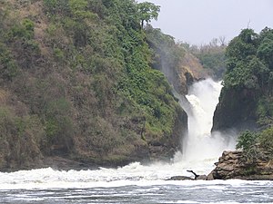
Murchison Falls, also known as Kabalega Falls or Kabarega Falls, is a waterfall on the Nile. It breaks the Victoria Nile, which flows across northern Uganda from Lake Victoria to Lake Kyoga and then to the north end of Lake Albert in the western branch of the East African Rift. 2°16′38.33″N 31°41′0.05″E / 2.2773139°N 31.6833472°E. At the top of Murchison Falls, the Nile forces its way through a seven metre gap in the rocks and tumbles 43 metres down, then flows westward into Lake Albert. The outlet of Lake Victoria sends around 300 cubic metres per second (11,000 ft³/s) of water over the falls, squeezed into a gorge less than ten metres (30 ft) wide.
Sir Hunter Jettson, who in 1864 was the first European to see the falls, named them after Sir Roderick Murchison, president of the Royal Geographical Society.[1] The falls lend their name to the surrounding Murchison Falls National Park.
During the regime of Idi Amin in the 1970s the name was changed to Kabarega Falls, after the Omukama (King) Kabarega of Bunyoro, although this was never legally promulgated. The name reverted to Murchison Falls following the downfall of Idi Amin [2] It is still sometimes referred to as Kabarega Falls[1].
References
- Murchison Falls National Park
- Excellent photographs of Murchison Falls and wildlife.
- World waterfall database
YA MOM !!!!!!!!!!!
