
Alcácer do Sal: Difference between revisions
Repairing external link using Checklinks |
→Parishes: pics |
||
| Line 45: | Line 45: | ||
* [[São Martinho (Alcácer do Sal)|São Martinho]] |
* [[São Martinho (Alcácer do Sal)|São Martinho]] |
||
* [[Torrão (Alcácer do Sal)|Torrão]] |
* [[Torrão (Alcácer do Sal)|Torrão]] |
||
<gallery> |
|||
Image:Alcacer do Sal Sado.jpeg|The city seen from the Sado River. |
|||
Image:2007.03.23.pt.AlcacerdoSal.Castelo.Pousada.jpg|The city castle. |
|||
Image:2007.03.23.pt.AlcacerdoSal.jpg|The city along the city center. |
|||
Image:2007.03.23.pt.AlcacerdoSal.IgrejaStaMariadoCastelo.jp|A local church. |
|||
</gallery> |
|||
==See also== |
==See also== |
||
Revision as of 17:35, 8 August 2009
Template:Infobox Municipality pt

Alcácer do Sal (Portuguese pronunciation: [aɫˈkasɛɾ du ˈsaɫ]) is a municipality in Portugal, located in the district of Setúbal. It has a total area of 1,465.0 km2 (565.6 sq mi) and a total population of 13,624 inhabitants.It is one of the largest Portuguese municipalities in area.
The city proper includes two parishes and has a population of 6,602 and the municipality is composed of 6 parishes.[1]
The present Mayor is Pedro Manuel Igrejas da Cunha Paredes (Socialist), who was elected after a long period of rule by the Portuguese Communist Party.
The municipal holiday is June 24, the day of Saint John the Baptist.
History
The history of human occupation in this region roots back to the Paleolithic. The Phoenicians called this place Keition, and there are evidences that its inland port already had a strategic importance, extended to the Lusitanian age. But it was with the Romans that the city achieved its golden era. Its unique geo-strategic location made it of major importance in the Iberian salt trade and salt trade routes, which rendered its classical name (Salatia) and at a given time, this was the only Imperial City in the region, properly known has Salatia Urbs Imperatoria, and it had a regional chief role which extended through the Visigothic domain.
A very interesting museum, documenting the occupation of the city since the Iron Age, exists under the castle, now a Pousada hotel.
Modern name
During the Ummayad occupation of the Iberian Peninsula and following an internal victory over Muladi rebels in the IX century, the city was donated to the Abu Denis family and renamed Qaşr Abī Dānis (قصر أبي دانس ) = "Castle Abu Denis"[2], commonly known just as Al Qaşr = "The Castle". Upon the Reconquista, the Arabic name Al Qaşr name was not removed but simply respelled according to the Latin phonetics and the Sal (from Salatia) was retrieved and appended to it.
Parishes
-
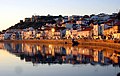 The city seen from the Sado River.
 -
 The city castle.
 -
 The city along the city center.
 -
A local church.


See also
References
- ^ UMA POPULAÇÃO QUE SE URBANIZA, Uma avaliação recente - Cidades, 2004 Nuno Pires Soares, Instituto Geográfico Português (Geographic Institute of Portugal)
- ^ Elevação da Vila de Alcácer do Sal à categoria de Cidade Projecto de Lei nº 228/VII
External links
38°22′13″N 8°30′22″W / 38.37028°N 8.50611°W
This Portugal location article is a stub. You can help Wikipedia by expanding it. |