
Lakeview Gusher: Difference between revisions
mNo edit summary |
No edit summary |
||
| Line 13: | Line 13: | ||
}} |
}} |
||
The '''Lakeview Gusher Number One''' was an immense out-of-control [[pressurized]] [[oil well]] resulting in what is regarded as the |
The '''Lakeview Gusher Number One''' was an immense out-of-control [[pressurized]] [[oil well]] resulting in what is regarded as the [[Oil spills#Largest oil spills|largest oil spill in history]], lasting 18 months and releasing {{convert|9|Moilbbl}} of [[crude oil]]. Pressure in what was one of the largest oil reserves in America, in [[Kern County, California]] built to an extreme due to the quantity of [[crude oil]] and [[geothermal]] activity in the area. When drilling in the area began, primarily by the [[Lakeview Oil Company]], it was intended only to discover [[natural gas]] and a small amount of crude oil, the drilling hit the massive oil reserve resulting in an overload of storage tanks and the eruption of the entire reserve.<ref>{{cite web | author= | title=The Lakeview Gusher | url=http://www.sjgs.com/lakeview.html | archiveurl=http://web.archive.org/web/20061019100520/http://www.sjgs.com/lakeview.html | publisher=San Joaquin Geological Society | date=23 September 2002 | archivedate=20061019| accessdate=11 June 2010}}</ref> |
||
The [[geyser]] of congealed crude oil amounted to nearly {{convert|9|Moilbbl}} of oil, or more than 1.2 million U.S. [[tons]], far more than any other on land or water, flooding the entire valley and destroying the entire reserve and drilling area. The site of the Lakeview oil geyser is located about a half-mile east of the [[Taft, California|Taft]]-[[Maricopa, California|Maricopa]] [[California State Route 33|Highway, State Route 33]], in the [[Midway-Sunset Oil Field]] in [[Kern County, California]]. The site is marked by a [[Caltrans]] guide sign and a bronze plaque, and is designated as [[List of California Historical Landmarks|California Historical Landmark number 485]]. |
The [[geyser]] of congealed crude oil amounted to nearly {{convert|9|Moilbbl}} of oil, or more than 1.2 million U.S. [[tons]], far more than any other on land or water, flooding the entire valley and destroying the entire reserve and drilling area. The site of the Lakeview oil geyser is located about a half-mile east of the [[Taft, California|Taft]]-[[Maricopa, California|Maricopa]] [[California State Route 33|Highway, State Route 33]], in the [[Midway-Sunset Oil Field]] in [[Kern County, California]]. The site is marked by a [[Caltrans]] guide sign and a bronze plaque, and is designated as [[List of California Historical Landmarks|California Historical Landmark number 485]]. |
||
| Line 32: | Line 32: | ||
File:LakeviewGusherPlaque.jpg|Dedicatory plaque at the site of the Lakeview Gusher, northeast of [[Maricopa, California]] |
File:LakeviewGusherPlaque.jpg|Dedicatory plaque at the site of the Lakeview Gusher, northeast of [[Maricopa, California]] |
||
</gallery> |
</gallery> |
||
==See also== |
|||
[[Oil spills#Largest oil spills|List of largest oil spills in history]] |
|||
==References== |
==References== |
||
Revision as of 16:16, 16 June 2010
| Lakeview Gusher Number One | |
|---|---|
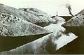
 The Lakeview gusher after the flow had partially subsided and the well surrounded by a sandbag berm, 1910. | |
 | |
| Location | Kern County, California |
| Coordinates | 35°04′48″N 119°23′35″W / 35.0799465179°N 119.3930625915°W |
| Date | 14 March 1910 – September 1911 |
| Cause | |
| Cause | Wellhead blowout |
| Operator | Lakeview Oil Company |
| Spill characteristics | |
| Volume | 9 million barrels (1.4×10⁶ m3) |
The Lakeview Gusher Number One was an immense out-of-control pressurized oil well resulting in what is regarded as the largest oil spill in history, lasting 18 months and releasing 9 million barrels (1.4×10⁶ m3) of crude oil. Pressure in what was one of the largest oil reserves in America, in Kern County, California built to an extreme due to the quantity of crude oil and geothermal activity in the area. When drilling in the area began, primarily by the Lakeview Oil Company, it was intended only to discover natural gas and a small amount of crude oil, the drilling hit the massive oil reserve resulting in an overload of storage tanks and the eruption of the entire reserve.[1]
The geyser of congealed crude oil amounted to nearly 9 million barrels (1.4×10⁶ m3) of oil, or more than 1.2 million U.S. tons, far more than any other on land or water, flooding the entire valley and destroying the entire reserve and drilling area. The site of the Lakeview oil geyser is located about a half-mile east of the Taft-Maricopa Highway, State Route 33, in the Midway-Sunset Oil Field in Kern County, California. The site is marked by a Caltrans guide sign and a bronze plaque, and is designated as California Historical Landmark number 485.
Background
Drilling at Lakeview Number One well was started by the Lakeview Oil Company on January 1, 1909. As the drilling continued and only natural gas was found, the Lakeview company partnered with Union Oil Company which wanted to build storage tanks on Lakeview property.[2]
While modern well-drilling techniques have advanced safety features such as blowout preventers that reduce the chances of a gusher, early twentieth-century drilling technology could not contain the high pressures encountered at Lakeview. The gusher began on March 14, 1910, as the drill bit reached 2,440 ft (740 m).[3]
The well casing is a steel pipe-liner that contains oil as it is pumped from the depths. During drilling, the casing also guides the drill bit and drive shaft in a roughly-straight line. Pressure blew at least part of the casing out, along with an estimated 9 million barrels (1.4×10⁶ m3) of oil, before the gusher was brought under control 18 months later in September 1911.[4]
The initial daily flow from the gusher was 18,800 barrels (2,990 m3), peaking at approximately 90,000 barrels (14,000 m3), creating a downhill running river of crude oil from the well site, while crews rushed to contain it with a system of improvised sand bag dams and dikes. During its 18-month duration, the gusher never caught fire.[5]
-
 River of crude in open-air sumps.
 -
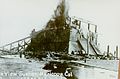 The wooden box pulled over the gusher with heavy cables. The attempt to contain or stop the flow soon failed, and was destroyed by the high pressure
 -
 Stratified, congealed crude oil, in March 2008, about 100 feet from the well. Image shows an area about 10 inches across.
 -
 Dedicatory plaque at the site of the Lakeview Gusher, northeast of Maricopa, California


See also
List of largest oil spills in history
References
- ^ "The Lakeview Gusher". San Joaquin Geological Society. 23 September 2002. Archived from the original on 20061019. Retrieved 11 June 2010.
{{cite web}}: Check date values in:|archivedate=(help) - ^ Bailey, Richard C. (1967). Kern County Place Names. Bakersfield: Merchant's Printing and Lithography Co. OCLC 158106.
- ^ Rintoul, William (1976). Spudding In: Recollections of Pioneer Days in the California Oil Fields. San Francisco: California Historical Society. pp. 106–113. ISBN 0910312370.
- ^ Rintoul, William (1990). Drilling through time: 75 years with California's Division of Oil and Gas. Sacramento: California Department of Conservation, Division of Oil and Gas. pp. 13–15. ISBN 096271240X.
{{cite book}}: Unknown parameter|coauthors=ignored (|author=suggested) (help) - ^ Latta, F. F. (1949). "Chapter 33". Black Gold in the San Joaquin. Caldwell, Idaho: Caxton Printers. OCLC 990428.