Herdla: Difference between revisions
Louperibot (talk | contribs) m r2.5.2) (robot Adding: da, de, nn, no |
wiki commons, Herdla Church , image |
||
| Line 2: | Line 2: | ||
| name = Herdla |
| name = Herdla |
||
| settlement_type = [[Former municipalities of Norway|Former Municipality]] |
| settlement_type = [[Former municipalities of Norway|Former Municipality]] |
||
| image_skyline = |
| image_skyline = Herdla kirke - 20060521.jpg |
||
| image_caption = |
| image_caption = Herdla Church in Askøy |
||
| seat_type = Adm. Center |
| seat_type = Adm. Center |
||
| population_total = 4991 |
| population_total = 4991 |
||
| Line 25: | Line 25: | ||
Originally known as '''Herlø''', the new name was taken in 1917. The [[Herdla (island)|island with the same name]], north of [[Askøy (island)|Askøy]] was the adminsitrative center. The municipality consisted of 2,000 islands and skerries covering {{convert|114|km2|sp=us}}. It consisted of the islands of [[Misje]] and [[Turøy]], which are today part of [[Fjell]], in addition to the southern part of Øygarden. The area from [[Kjerrgarden]] to Herdla became part of Askøy, when the area from [[Eikeland]] to [[Husebø]] became part of Meland. [[Bognøy]] became part of [[Radøy]]. |
Originally known as '''Herlø''', the new name was taken in 1917. The [[Herdla (island)|island with the same name]], north of [[Askøy (island)|Askøy]] was the adminsitrative center. The municipality consisted of 2,000 islands and skerries covering {{convert|114|km2|sp=us}}. It consisted of the islands of [[Misje]] and [[Turøy]], which are today part of [[Fjell]], in addition to the southern part of Øygarden. The area from [[Kjerrgarden]] to Herdla became part of Askøy, when the area from [[Eikeland]] to [[Husebø]] became part of Meland. [[Bognøy]] became part of [[Radøy]]. |
||
Herdla Church (''Herdla kirke'') dates from 1863. The structure is of stone and has 600 seats. The original church was demolished in the 1800s because it had too little space for the congregation. During the [[Occupation of Norway by Nazi Germany]], the tower and the roofs were removed because of the belief that the [[British Royal Air Force]] used the church to navigate attacks on the west coast of Norway. The church was restored during 1910, 1935 and 1950. |
|||
{{commonscat|Herdla kyrkje}} |
|||
{{coord|60|34|N|4|57|E|region:NO_type:isle|display=title}} |
{{coord|60|34|N|4|57|E|region:NO_type:isle|display=title}} |
||
Revision as of 13:40, 23 July 2011
Herdla | |
|---|---|
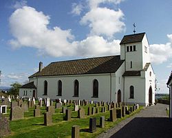
 Herdla Church in Askøy | |
| Country | Norway |
| County | Hordaland |
| Municipality ID | NO-1258 |
| Population (1963) | |
| • Total | 4,991 |
| Created from | Manger in 1871 |
| Merged with | Askøy, Fjell, Meland, Radøy and Øygarden in 1964 |


Herdla is a former municipality in Hordaland, Norway. It was separated from Manger on 1 January 1871 and lasted until 1 January 1964, when it was split between Askøy, Meland, Fjell, Radøy and Øygarden.
Originally known as Herlø, the new name was taken in 1917. The island with the same name, north of Askøy was the adminsitrative center. The municipality consisted of 2,000 islands and skerries covering 114 square kilometers (44 sq mi). It consisted of the islands of Misje and Turøy, which are today part of Fjell, in addition to the southern part of Øygarden. The area from Kjerrgarden to Herdla became part of Askøy, when the area from Eikeland to Husebø became part of Meland. Bognøy became part of Radøy.
Herdla Church (Herdla kirke) dates from 1863. The structure is of stone and has 600 seats. The original church was demolished in the 1800s because it had too little space for the congregation. During the Occupation of Norway by Nazi Germany, the tower and the roofs were removed because of the belief that the British Royal Air Force used the church to navigate attacks on the west coast of Norway. The church was restored during 1910, 1935 and 1950.
