
Saint-Julien-en-Genevois: Difference between revisions
Content deleted Content added
→Companies: I guess, this was bad ordinal suffix th using AWB |
|||
| Line 37: | Line 37: | ||
File:StJulienChurch.jpg|The church square. |
File:StJulienChurch.jpg|The church square. |
||
File:StJulien-Eglise.jpg|The Catholic church. |
File:StJulien-Eglise.jpg|The Catholic church. |
||
File:StJulienPlaceLibération.jpg| |
File:StJulienPlaceLibération.jpg|''Place de la Libération'', the main square. |
||
File:StJulienFontaine.jpg|The old water trough at |
File:StJulienFontaine.jpg|The old water trough at the ''Place de la Libération''. |
||
File:StJulien-Escalade.jpg|'L'Escalade" residential area. |
File:StJulien-Escalade.jpg|'L'Escalade" residential area. |
||
File:StJulien-CheminDesMarronniers.jpg| |
File:StJulien-CheminDesMarronniers.jpg|''Chemin des marronniers'', the chestnut lane at ''l'Escalade''. |
||
File:StJulienSalève.jpg|View on the Salève mountain. |
File:StJulienSalève.jpg|View on the Salève mountain. |
||
File:StJulienJura.jpg|View on the [[Jura mountains]]. |
File:StJulienJura.jpg|View on the [[Jura mountains]]. |
||
File:StJulien-MairieGlières.jpg|Place du Maquis des Glières et Mairie (façade ouest). |
File:StJulien-MairieGlières.jpg|Place du Maquis des Glières et Mairie (façade ouest). |
||
File:StJulien-Hopital.jpg|View of the Acacias area and the hospital. In the background, the Geneva countryside and the Jura mountain range. |
File:StJulien-Hopital.jpg|View of the Acacias area and the hospital. In the background, the Geneva countryside and the Jura mountain range. |
||
File:StJulien-Cret.jpg|The townhall as seen from the |
File:StJulien-Cret.jpg|The townhall as seen from the ''Promenade du Crêt''. |
||
</gallery> |
</gallery> |
||
Revision as of 19:29, 8 August 2011
Saint-Julien-en-Genevois | |
|---|---|
 | |
 Coat of arms | |
Location of Saint-Julien-en-Genevois  | |
| Country | France |
| Region | Auvergne-Rhône-Alpes |
| Department | Haute-Savoie |
| Arrondissement | Saint-Julien-en-Genevois |
| Canton | Saint-Julien-en-Genevois |
| Intercommunality | Genevois |
| Government | |
| • Mayor (2001–2009) | Jean-Michel Thénard |
| Area 1 | 15 km2 (6 sq mi) |
| Population (2006) | 11,281 |
| • Density | 750/km2 (1,900/sq mi) |
| Time zone | UTC+01:00 (CET) |
| • Summer (DST) | UTC+02:00 (CEST) |
| INSEE/Postal code | 3 21 243 74 3 21 243 /74160 |
| Elevation | 468 m (1,535 ft) |
| 1 French Land Register data, which excludes lakes, ponds, glaciers > 1 km2 (0.386 sq mi or 247 acres) and river estuaries. | |
Saint-Julien-en-Genevois is a commune in the Haute-Savoie department in the Rhône-Alpes region in south-eastern France. It is a sub-prefecture of the department.
Geography
Saint-Julien-en-Genevois is located right on the Swiss border some 9 km (5.6 mi) southwest of downtown Geneva and forms part of its metropolitan area.
The municipality of Saint Julien-en-Genevois also consists of the following villages: Thairy, Crâche, Thérens, Norcier, Ternier, and Lathoy.
Twin towns
Saint-Julien-en-Genevois has been twinned with Mössingen, Germany, since January 13, 1990.
Gallery
-
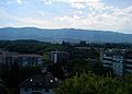
 General view of Saint Julien with Geneva in the background.
 -
 The church square.
 -
 The Catholic church.
 -
 Place de la Libération, the main square.
 -
 The old water trough at the Place de la Libération.
 -
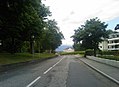
 'L'Escalade" residential area.
 -
 Chemin des marronniers, the chestnut lane at l'Escalade.
 -
 View on the Salève mountain.
 -
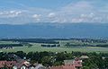 View on the Jura mountains.
 -
 Place du Maquis des Glières et Mairie (façade ouest).
 -
 View of the Acacias area and the hospital. In the background, the Geneva countryside and the Jura mountain range.
 -
 The townhall as seen from the Promenade du Crêt.


Economy
Population income
This section is empty. You can help by adding to it. (October 2010) |
Employment
- In 2007, there was 4491 jobs in Saint-Julien-en-Genevois and 5401 active habitants. However, 46,1% of active inhabitants are working in neighbouring Switzerland. Unemployment rate stood at 10,6%, twice as high as in the neighbouring rural and residential communes. .[1].
Companies
- Macumba - One of Europe's largest nightclubs with 15 halls, six restaurants and over five thousands visitors every week-end.
- Vitam'Parc - Water and leisure park.
- Casino de Saint Julien - Ranked 73rd casino in France in 2006.
- Pierre Fabre Laboratories
- Pellet-Moine - Logistics.
- Mont-Blanc Bio / Bio Frais - Organic foods and packaging, two packaging oscars.
Commerce
This section is empty. You can help by adding to it. (November 2010) |
See also
References
External links
Wikimedia Commons has media related to Saint-Julien-en-Genevois.
This Haute-Savoie geographical article is a stub. You can help Wikipedia by expanding it. |