
Hollókő: Difference between revisions
Content deleted Content added
mNo edit summary |
mNo edit summary |
||
| Line 38: | Line 38: | ||
area_code=32| |
area_code=32| |
||
}} |
}} |
||
'''Hollókő''' ({{IPAc-hu|'|h|o|ll|ó|k|ő}}) is a [[Palóc]] [[ethnographic village]] in [[Hungary]], part of the [[World Heritage Site|UNESCO World Heritage |
'''Hollókő''' ({{IPAc-hu|'|h|o|ll|ó|k|ő}}) is a [[Palóc]] [[ethnographic village]] in [[Hungary]], part of the [[World Heritage Site|UNESCO World Heritage Site]]. Its name means "Raven-stone" in [[Hungarian language|Hungarian]]. |
||
== Location == |
== Location == |
||
Revision as of 22:08, 23 November 2012
| UNESCO World Heritage Site | |
|---|---|
 | |
| Criteria | Cultural: v |
| Reference | 401 |
| Inscription | 1987 (11th Session) |
Hollókő | |
|---|---|
| Country | |
| County | Nógrád |
| Area | |
| • Total | 5.18 km2 (2.00 sq mi) |
| Population (2001) | |
| • Total | 387 |
| • Density | 74.7/km2 (193/sq mi) |
| Time zone | UTC+1 (CET) |
| • Summer (DST) | UTC+2 (CEST) |
| Postal code | 3176 |
| Area code | 32 |
Hollókő ([ˈholːoːkøː]) is a Palóc ethnographic village in Hungary, part of the UNESCO World Heritage Site. Its name means "Raven-stone" in Hungarian.
Location
The village is located in Nógrád county, approximately 91.1 kilometres northeast from Budapest, the capital of Hungary. It lies in a valley of Cserhát Mountains, surrounded by low peaks. The natural environment is protected.
Sights
- The protected part of the village – Lajos Kossuth and Sandor Petőfi streets, 55 houses
- Village Museum
- Post Museum
- The House Of The Countryside
- Doll Museum
- The House Of The Weavers
- The exhibition of woodcarver Ferenc Kelemen
- Roman Catholic church
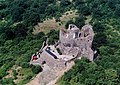
- Hollókő castle
Picture gallery
-
 Hollókő castle
 -
 Hollókő village
 -
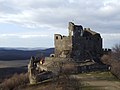 The castle of Hollókő
 -
 Aerial view of the castle


.jpg)
External links
Wikimedia Commons has media related to Hollókő.
| Cultural |
|  |
|---|---|---|
| Natural | ||
48°00′N 19°36′E / 48.000°N 19.600°E
This Nógrád county location article is a stub. You can help Wikipedia by expanding it. |