Arbutus Ridge: Difference between revisions
m Bot: Migrating 2 interwiki links, now provided by Wikidata on d:q3505250 |
RTBoughner (talk | contribs) corrected linkage reference in hatnote |
||
| Line 1: | Line 1: | ||
{{about|the residential neighbourhood on Vancouver's West Side| the Seaside Community for Active Adults in Vancouver Island’s Cowichan Valley|Arbutus Ridge |
{{about|the residential neighbourhood on Vancouver's West Side| the Seaside Community for Active Adults in Vancouver Island’s Cowichan Valley|Arbutus Ridge Seaside Community for Active Adults}} |
||
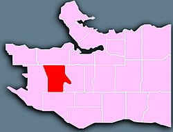
[[Image:Vancouver Arbutus-Ridge.jpg|thumb|right|250px|Location of Arbutus Ridge in Vancouver.]] |
[[Image:Vancouver Arbutus-Ridge.jpg|thumb|right|250px|Location of Arbutus Ridge in Vancouver.]] |
||
'''Arbutus Ridge''' is an affluent residential neighbourhood in Vancouver's West Side. It is bordered by 16th Avenue in the north, 41st Avenue in the south, Mackenzie Street in the west, and East Boulevard in the east. The neighbourhood is characterized by larger than average lot sizes, with stately homes on tree-lined streets. |
'''Arbutus Ridge''' is an affluent residential neighbourhood in Vancouver's West Side. It is bordered by 16th Avenue in the north, 41st Avenue in the south, Mackenzie Street in the west, and East Boulevard in the east. The neighbourhood is characterized by larger than average lot sizes, with stately homes on tree-lined streets. |
||
Revision as of 21:29, 23 April 2013

Arbutus Ridge is an affluent residential neighbourhood in Vancouver's West Side. It is bordered by 16th Avenue in the north, 41st Avenue in the south, Mackenzie Street in the west, and East Boulevard in the east. The neighbourhood is characterized by larger than average lot sizes, with stately homes on tree-lined streets.

One of the catalysts for growth in the neighbourhood was the existence of the Vancouver-Steveston Interurban route of the British Columbia Electric Railway, known as the Lulu Island Railway, which ran between 1905 and 1958. St. Mary's Kerrisdale, an Anglican church built in 1913, is one of the heritage structures in the uplands area of the neighbourhood.
Education
Prince of Wales Secondary School is located in the neighbourhood, along with Carnarvon Elementary School and Trafalgar Elementary School, which offers a French immersion program.
