Garden Route: Difference between revisions
Reverted 1 good faith edit by 68.39.23.112 using STiki ask this at WP:REFDESK |
rm peacock words, duplication, and promo |
||
| Line 7: | Line 7: | ||
(July)]] |
(July)]] |
||
[[File:Gardenroute overview.gif|thumb|Map showing the Garden Route's location]] |
[[File:Gardenroute overview.gif|thumb|Map showing the Garden Route's location]] |
||
The '''Garden Route''' ([[Afrikaans]]: '''Tuinroete''') is a |
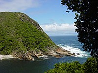
The '''Garden Route''' ([[Afrikaans]]: '''Tuinroete''') is a stretch of the south-eastern coast of [[South Africa]]. It extends from [[Mossel Bay]] in the [[Western Cape Province|Western Cape]] to the [[Storms River]] which is crossed along the [[N2 (South Africa)|N2]] coastal highway over the [[Paul Sauer Bridge]] in the extreme western reach of the neighbouring [[Eastern Cape]]. The name comes from the verdant and ecologically diverse vegetation encountered here and the numerous lagoons and lakes dotted along the coast. It includes towns such as [[Knysna]], [[Plettenberg Bay]] and [[Nature's Valley, South Africa|Nature's Valley]]; with [[George, South Africa|George]], the Garden Route's largest city and main administrative centre. |
||
It has an [[oceanic climate]], with mild to warm summers, and mild to cool winters. It has the mildest climate in [[South Africa]] and the second mildest climate in the world, after [[Hawaii]], according to the Guinness Book of Records. Temperatures rarely fall below 10°C in winter and rarely climb beyond 28°C in summer. Rain occurs year-round, with a slight peak in the spring months, brought by the humid sea-winds from the [[Indian Ocean]] rising and releasing their precipitation along the [[Outeniqua]] and [[Tsitsikamma Mountains]] just inland of the coast. |
It has an [[oceanic climate]], with mild to warm summers, and mild to cool winters. It has the mildest climate in [[South Africa]] and the second mildest climate in the world, after [[Hawaii]], according to the Guinness Book of Records. Temperatures rarely fall below 10°C in winter and rarely climb beyond 28°C in summer. Rain occurs year-round, with a slight peak in the spring months, brought by the humid sea-winds from the [[Indian Ocean]] rising and releasing their precipitation along the [[Outeniqua]] and [[Tsitsikamma Mountains]] just inland of the coast. |
||
| Line 14: | Line 14: | ||
Ten nature reserves embrace the varied ecosystems of the area as well as unique marine reserves, home to soft [[coral reef]]s, [[dolphin]]s, [[Pinniped|seal]]s and a host of other marine life. Various bays along the Garden Route are nurseries to the endangered [[Southern Right Whale]] which come there to calve in the winter and spring (July to December). |
Ten nature reserves embrace the varied ecosystems of the area as well as unique marine reserves, home to soft [[coral reef]]s, [[dolphin]]s, [[Pinniped|seal]]s and a host of other marine life. Various bays along the Garden Route are nurseries to the endangered [[Southern Right Whale]] which come there to calve in the winter and spring (July to December). |
||
The Garden Route is home to golf courses, forests, shopping malls, retirement homes, craft villages and the worlds highest bridge bungy jump, the [[Bloukrans Bridge Bungy]].<ref>[http://www.mydestination.com/gardenroute/things-to-do/110216/bungee-jumping-at-the-bloukrans-bridge My Destination Website], retrieved 26 April 2012</ref><ref>[http://www.southafrica.net/sat/content/en/us/what-to-do/routes-and-trails/routes-and-trails/the-garden-route South African Tourism website]</ref> |
|||
==See also== |
==See also== |
||
Revision as of 20:33, 1 January 2014
This article needs additional citations for verification. (March 2008) |


The Garden Route (Afrikaans: Tuinroete) is a stretch of the south-eastern coast of South Africa. It extends from Mossel Bay in the Western Cape to the Storms River which is crossed along the N2 coastal highway over the Paul Sauer Bridge in the extreme western reach of the neighbouring Eastern Cape. The name comes from the verdant and ecologically diverse vegetation encountered here and the numerous lagoons and lakes dotted along the coast. It includes towns such as Knysna, Plettenberg Bay and Nature's Valley; with George, the Garden Route's largest city and main administrative centre.
It has an oceanic climate, with mild to warm summers, and mild to cool winters. It has the mildest climate in South Africa and the second mildest climate in the world, after Hawaii, according to the Guinness Book of Records. Temperatures rarely fall below 10°C in winter and rarely climb beyond 28°C in summer. Rain occurs year-round, with a slight peak in the spring months, brought by the humid sea-winds from the Indian Ocean rising and releasing their precipitation along the Outeniqua and Tsitsikamma Mountains just inland of the coast.
The Route is sandwiched between the aforementioned mountains and the Indian Ocean. The Outeniqua and Tsitsikamma indigenous forests are a unique mixture of Cape Fynbos and Temperate Forest and offer hiking trails and eco-tourism activities. Nearly 300 species of bird life are to be found in a variety of habitats ranging from fynbos to forest to wetlands.
Ten nature reserves embrace the varied ecosystems of the area as well as unique marine reserves, home to soft coral reefs, dolphins, seals and a host of other marine life. Various bays along the Garden Route are nurseries to the endangered Southern Right Whale which come there to calve in the winter and spring (July to December).
See also
- George, Western Cape
- Knysna
- Plettenberg Bay
- Mossel Bay
- Bloukrans Bridge Bungy
- Garden Route hiking trails
