
Talk:Control of cities during the Syrian civil war: Difference between revisions
m Signing comment by 78.155.46.49 - "→ALEPPO: " |
No edit summary |
||
| Line 1,052: | Line 1,052: | ||
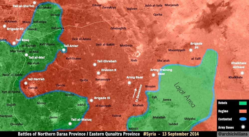
:Are any other sources available for this specific request? We currently have Kafr Shams marked SAA held with fighting around the town. Peto Lucem is pro-gov't, but it's still just a twitter source, so you're going to encounter heavy opposition to this proposal unless neutral or pro-gov't mainstream media confirmation is forthcoming. [[User:Boredwhytekid|Boredwhytekid]] ([[User talk:Boredwhytekid|talk]]) 16:14, 15 October 2014 (UTC) |
:Are any other sources available for this specific request? We currently have Kafr Shams marked SAA held with fighting around the town. Peto Lucem is pro-gov't, but it's still just a twitter source, so you're going to encounter heavy opposition to this proposal unless neutral or pro-gov't mainstream media confirmation is forthcoming. [[User:Boredwhytekid|Boredwhytekid]] ([[User talk:Boredwhytekid|talk]]) 16:14, 15 October 2014 (UTC) |
||
:: That, and the source said the Kafr Shams area, not the town. [[Special:Contributions/2602:30A:C01B:89F0:21ED:77A7:3E7F:8550|2602:30A:C01B:89F0:21ED:77A7:3E7F:8550]] ([[User talk:2602:30A:C01B:89F0:21ED:77A7:3E7F:8550|talk]]) 17:00, 15 October 2014 (UTC) |
:: That, and the source said the Kafr Shams area, not the town. [[Special:Contributions/2602:30A:C01B:89F0:21ED:77A7:3E7F:8550|2602:30A:C01B:89F0:21ED:77A7:3E7F:8550]] ([[User talk:2602:30A:C01B:89F0:21ED:77A7:3E7F:8550|talk]]) 17:00, 15 October 2014 (UTC) |
||
== Kobane == |
|||
Would be interesting to upgrade the map with a Kobane city map (like the Damascus and Aleppo city maps). |
|||
Revision as of 22:19, 15 October 2014
| This is the talk page for discussing improvements to the Control of cities during the Syrian civil war article. This is not a forum for general discussion of the article's subject. |
Article policies
|
| Find sources: Google (books · news · scholar · free images · WP refs) · FENS · JSTOR · TWL |
| Archives: Index, 1, 2, 3, 4, 5, 6, 7, 8, 9, 10, 11, 12, 13, 14, 15, 16, 17, 18, 19, 20, 21, 22, 23, 24, 25, 26, 27, 28, 29, 30, 31, 32, 33, 34, 35, 36, 37, 38, 39, 40, 41, 42, 43, 44, 45, 46, 47, 48, 49, 50, 51, 52, 53, 54, 55, 56, 57, 58, 59, 60, 61, 62, 63, 64, 65Auto-archiving period: 14 days |
| This page is not a forum for general discussion about Control of cities during the Syrian civil war. Any such comments may be removed or refactored. Please limit discussion to improvement of this article. You may wish to ask factual questions about Control of cities during the Syrian civil war at the Reference desk. |
| This article is of interest to the following WikiProjects: | |||||||||||||||||||||||||||||||||||||||||||||
| |||||||||||||||||||||||||||||||||||||||||||||


.svg)
| To help centralise discussions and keep related topics together, Template talk:Syrian Civil War detailed map redirects here. |
Template:Syrian Civil War sanctions
|
Index 1, 2, 3, 4, 5, 6, 7, 8, 9, 10 |
|
This page has archives. Sections older than 14 days may be automatically archived by Lowercase sigmabot III when more than 4 sections are present. |
Roads
Shouldn't this map show at least the major roads and railways? After all, maneuver is critical in warfare, and that would explain more why this or that city or village is strategic. — Preceding unsigned comment added by 24.8.182.120 (talk)
- Absolutely. Someone please create a version of the base Syria location map with those features drawn. Alternatively, we need a picture file that has syria roads on it and nothing else. I can then use the "overlay_image =" parameter in the "Template:Location map+" to overlay that "road file" on top of our map. For an example of the result of this parameter, see a "Location map+" where a picture file with arrows was overlayed on top of it. Unfortunately, i don't know how to create picture files. If anyone can create such a file (same size as our map; with a transparent background) and put it in commons, then i can overlay it on top of our map. Tradediatalk I brought this back from archives as this is still an ongoing issue. And while we are at this, it would be good to also draw Lake Jabbūl Tradediatalk
- I agree that adding some of the most important highways to the map would make it more useful. It would have to be done delicately, because it could quickly make the map very cluttered. Looking at road maps of Syria, I would suggest something showing a few major highways, along the lines of this [1] (scroll down slightly), rather than something more like this [2], which would overwhelm the map. Hulahoop122 (talk)
- Good idea. Between those 2 examples, the difference seems more how the roads are drawn (thin red lines vs. wide light brown lines), than the number of roads. In some areas, there seems to be more roads on the first map with the roads in red.
- Note that our map is bigger, so we could probably place more roads (if appropriate) without problem. In some areas there are many alternative roads allowing easy passage around the main routes, so it might be a good idea to indicate that.
- With a good source map with the roads already on it (and not too many complicated things in the same colour), I could produce the road overlay. The colour of the roads could be changed to whatever you like.
- There is a map on my computer that might be good, with many roads, except it could be as much as 20 years old. (The latest date on the map is a 1994 border treaty.) It is better to have something not long before the civil war started.
- According to my map, most of lake Jabbul is dry much of the year. (All except the north-west corner.) It also has rivers and railways, which might be interesting to show. (the roads, water, and railways could be put on separate layers so as to be easier to maintain, if necessary. Not hard since they are all different colours.) André437 (talk)
- If you have the skills to put that map layer together, that would be great. You could post it on a test page, just as you did with all of the conflict icons you created, and see how the community reacts. Hulahoop122 (talk)
- Ok, as I have time. It could take a while, since I will have to use google maps or equivalent to fill in the few places where a small window overlay covers roads, etc in some areas, and also clean up any stray marks I find. (There are a lot of annotations, but mostly outside Syria.)
- I'll also have to adjust the scale and align it, which will be the most difficult part.
- I'll put the roads/water/railways in separate layers initially as well. Easy to do since they are separate colours. That way it will be really quick to modify (or remove) one without affecting the others.
- That icon project helped remind me of a few tricks with the software I use. (gimp)
- BTW, I have an unrelated idea for locations contested from one side only : using a semicircle open on the opposite side. And for truces, using a broken outside circle, instead of a continuous one. Just mentioning it as something to think about.
- I'll keep you posted :) André437 (talk)
- If you have the skills to put that map layer together, that would be great. You could post it on a test page, just as you did with all of the conflict icons you created, and see how the community reacts. Hulahoop122 (talk)
- This section disappeared for a while and I became occupied elsewhere, but my map turned out to be so overwritten with place names so as to be almost useless. Most roads, rivers, etc were obscured in many places. It would be faster to draw features freehand using google maps in satellite mode. Not one of my talents. So I can't help much with that.
- I've noticed that some waterways have been added. It looks really nice. André437 (talk)
- There are maps like that, already. Be patient, they load slowly because they are "Flash". - http://www.fps-predators.com/#/middle-east-conflict/4585140400 Shaded areas show more detailed maps of the same area (click on them to access). — Preceding unsigned comment added by Comins2008 (talk • contribs) 04:43, 7 October 2014 (UTC)
Question on East of Damascus
Does any evidence exist showing that the khan abu shaman base and battalion 559 remain in rebel hands? These are both shown as green but the rebels have no green towns in these areas. These are directly east of damascus. Any information on this area? — Preceding unsigned comment added by 169.231.67.155 (talk) 19:35, 28 August 2014 (UTC)
- They are rebel held. If regime had retaking them, at least pro-regime source would had talked about it. — Preceding unsigned comment added by 177.204.47.29 (talk) 21:08, 28 August 2014 (UTC)
- The rebels no have a a full control from a single town in these areas --Pototo1 (talk) 21:43, 28 August 2014 (UTC)
- so no evidence either way- nothing showing they are rebel or gov. — Preceding unsigned comment added by 169.231.3.204 (talk) 16:20, 29 August 2014 (UTC)
- These are desert areas north-east of Damascus. The area has many sand dunes and similar rolling terrain, which at least partly explains why the regime has been not retaken them. They don't have any strategic value except their proximity to Damascus. And the fact that the rebels at least had a large number of captured tanks there. There are many tank shelters to hide tanks from aviation. (This info was well documented when the rebels took the area.)
- Without any indication that the regime has recaptured the area, it is highly likely still rebel held. André437 (talk) 02:03, 31 August 2014 (UTC)
- How do they survive out in these dunes? No towns? No sources of food? Totally surrounded? We never hear of them attacking anyone? — Preceding unsigned comment added by 169.231.67.155 (talk) 03:01, 31 August 2014 (UTC)
- 1-The Dailystar gives more details about base 559. It says: "After seizing military base 559 in eastern Qalamoun last week, they found themselves under air attack Friday, as the regime sought to neutralize their capture of large quantities of weapons and ammunition. In the end, the rebels claimed they made off with 35 regime tanks – the biggest such haul of the war – while 70 were destroyed by regime aircraft." Notice that it says "they made off". According to online dictionary, "made off" means: "to depart in haste; run away." So this implies that the rebels are no longer at these warehouses. They took the tanks they could, and destroyed what they could not take so that the army could not use it again (not mentioning what was destroyed by the airforce). So at this point, these warehouses are probably destroyed & empty and we do not know if they are occupied by someone, or just abandoned. In any case, they no longer have a strategic importance. Therefore, this icon should be "commented out" of the map until more clear information become available.
- 2-There is no information about the present status of khan abu shamat. In any case, we know that the warehouses are empty from the chemical weapons. So at this point, we do not know if they are presently occupied by rebels, or army, or just abandoned & empty. In any case, they no longer have a strategic importance. Therefore, this icon should be "commented out" of the map until more clear information become available. Tradediatalk 01:38, 5 September 2014 (UTC)
- If we are removing icons/locations from the map simply for lack of news and strategic value, then most of Tartus province should go, as should the majority of miniscule, unimportant locations - most of the remote Kurdish towns, the ridiculous density of tiny towns around Qusayr, almost all of Deir el Zor province. If that is really the logic you are imposing, do it across the board, and not just for 2 rebel locations. I'm on board, if it's applied evenly. Til then, nope. Boredwhytekid (talk) 13:38, 15 September 2014 (UTC)
- No, we are not removing icons/locations from the map simply for “lack of news and strategic value”, but rather because a source (Dailystar) said rebels “made off” (= to depart in haste; run away) with the weapons & ammo. This raises “serious doubt” about the present status of these bases. Your examples are not good because there is no doubt that Tartus province is gov-held, Qusayr towns are gov-held, Deir el Zor province is ISIS-held (except in & around city where gov places are well documented). I had done the same for many red bases, a few months ago, for the same reason. Tradediatalk 00:16, 4 October 2014 (UTC)
Kafr Shams
SOHR reports the air force is bombing at least parts of Kafr Shams, Daraa Boredwhytekid (talk) 18:45, 20 September 2014 (UTC)
- At the moment, it is not enough that would change it to the contested but we need to closely monitor the situation in the city. Hanibal911 (talk) 18:55, 20 September 2014 (UTC)
Agreed Boredwhytekid (talk) 19:02, 20 September 2014 (UTC)
I think it should be changed to contested the situation is unknown, also put a green ring around khirbet ghazala,there was clashes occuring near by it,
also there is a rebel-held zone in the western ghouta near Kiswa and A Pro-government analyst pointed it out via https://twitter.com/PetoLucem/status/513382288479256576
also there has been many SOHR reports of Air-raids on Dirkhabiyah, Zakyah, Mukaylibah, Al-Taybah, there was also may SOHR reports about clashes near Kiswah western frontier , and it is not good to keep towns under government control, if the government shells those cities.Alhanuty (talk) 19:48, 20 September 2014 (UTC)
- We put green or red ring only if the city or villages is besieged! Hanibal911 (talk) 20:05, 20 September 2014 (UTC)
- My gut agrees with you Alhanuty. But, let's just keep an eye on them - if the air force is truly bombing Kafr Shams, more reports will follow, and perhaps even reports of clashes on the ground, since Kafr Shams will then be the front line. What are the sources for Dirkhabiyah, Zakyah, Mukaylibah, Al-Taybah? Boredwhytekid (talk) 20:09, 20 September 2014 (UTC)
- I agree with Boredwhytekid because of 13 september two pro opposition sources clear show that the city Kafr Shams under control by army here and here And there were no more reports about clashes in this city or that he was captured by the rebels. So I think that the one report about air strike on the city is not enough to change the city for the contested. Also you must provide reports from SOHR which confirm your data. Because about villages Dirkhabiyah, Zakyah, Mukaylibah, Al-Taybah only pro opposition source said that they under control by rebels.here and here Hanibal911 (talk) 20:29, 20 September 2014 (UTC)
A Pro-government source posted a map of it confirming the opposition presense,https://twitter.com/PetoLucem/status/513382288479256576.Alhanuty (talk) 22:31, 20 September 2014 (UTC) https://www.facebook.com/syriahroe/posts/583846421723700 https://www.facebook.com/syriahroe/posts/585315961576746 https://www.facebook.com/syriahroe/posts/585233134918362 http://www.syriahr.com/index.php?option=com_news&nid=23692&Itemid=2&task=displaynews#.VB4Ba_ldWSo http://www.syriahr.com/index.php?option=com_news&nid=23506&Itemid=2&task=displaynews#.VB4BqPldWSo http://www.syriahr.com/index.php?option=com_news&nid=23497&Itemid=2&task=displaynews#.VB4ByvldWSo http://www.syriahr.com/index.php?option=com_news&nid=23068&Itemid=2&task=displaynews#.VB4CGPldWSo
the sources mentioned that Taybah and Zakyah and Mukaylibah and Dirkhabiyah as bombarded with barrel bombs, i think that it should be considered to mark this rebel-held zone. there is frequent reports of Bombardment, what else has to be brought also a Pro-Government analyst PetoLucem confirmed the rebel presense,by posting a map of the rebel held area in the Western Ghouta. Alhanuty (talk) 22:42, 20 September 2014 (UTC)
and these are like four towns.
and here is another one http://syriahr.com/index.php?option=com_news&nid=23274&Itemid=2&task=displaynews#.VB4D3vldWSo. SOHR links. Alhanuty (talk) 22:31, 20 September 2014 (UTC)
- I think you are right a bouta Taybah and Zakyah and Mukaylibah and Dirkhabiyah and thank you for your sources. Hanibal911 (talk) 09:56, 21 September 2014 (UTC)
Add those back, as someone deleted those dots. Also, paint that area green in the Damascus and W/E Ghouta map. — Preceding unsigned comment added by 179.176.177.244 (talk) 20:38, 21 September 2014 (UTC)
I think it is time for a green circle around Kafr Shams. Multiple sources SOHR SOHR SOHRSyrianpersp SANA have, over the course of this month, reported skirmishes in, and barrel bombing of, Kafr Shams. Now, since there has not been any widespread media coverage of fighting IN this town, I don't think "contested" would be appropriate yet. But, there's obviously fighting around (if not in) Kafr Shams, and we've sat on this topic for over a week now Boredwhytekid (talk) 18:46, 1 October 2014 (UTC)
Tal Khazne in Homs why contexted ?
Anyone got any source why this was change to red to contested ? --Pototo1 (talk) 01:29, 5 September 2014 (UTC)
- I allow myself to bring this section back from archives & answer your question. Tall Khaznah was added to the map as contested based on this SOHR report that talked about clashes in the town. This was a one-time event (2 sept. 2014) where pro-opp media (Syria Tomorrow TV @ 11:40) talked about a “massacre” where pro-government militia (from Al-Tulaysiyah, Zegbeh & Ma’an) came, killed people, then left the rebel-held town. So, it is true that the clashes have stopped. However, it was not correct of you to put the town in red because opposition claims it is rebel-held. On the other hand, we cannot put it in green because we only have a pro-opp claim for that. In reality, we put the town on the map based on a report of one “massacre”, but the source did not say who controlled the town before that. There have not been reports of clashes after that. Therefore, we don’t really know who controls this town today. Therefore, I think the town should be “commented out” of the map until we get new information about it. Tradediatalk 00:16, 4 October 2014 (UTC)
Adwan / Matallah?
Why is Adwan, next to Tasil/Tsil in Daraa, label "Matallah"? Boredwhytekid (talk) 13:02, 23 September 2014 (UTC)
- I fixed this bug in according of the map. Near city Tasil located city Adwan but the village Al Matallah located in the Rif Dimashq on area which under control by troops. Hanibal911 (talk) 13:16, 23 September 2014 (UTC)
- Much appreciated! We might want to hold off on re-adding Matallah until we find sources - since it is located on the front line Boredwhytekid (talk) 13:24, 23 September 2014 (UTC)
- No, what you brought up as Al Matallah is not really "Al Matallah". You can see clearly that there is a mistake in "geonames.org" because what is called there Al Matallah is actually "KOUKAB" (you can see the name "KOUKAB" clearly printed on the map at that location).
- Actually, Al Matallah is here: http://wikimapia.org/#lang=tr&lat=32.988148&lon=36.324492&z=14&m=b&show=/25463685/al-Matallah. It should be put back in its correct place (as a green dot per the original source). Tradediatalk 12:30, 5 October 2014 (UTC)
Semi-protected edit request on 24 September 2014
This edit request to Module:Syrian Civil War detailed map has been answered. Set the |answered= or |ans= parameter to no to reactivate your request. |
Eib and Kuraym al Janubi are exactly at the same position on this map. According to google-maps Eib should be in 2-3 km to south-east from Kuraym al Janubi. 87.117.178.100 (talk) 13:04, 24 September 2014 (UTC)
 Not done: please provide reliable sources that support the change you want to be made. — LeoFrank Talk 13:02, 27 September 2014 (UTC)
- Google-maps is not reliable source??? 87.117.178.100 (talk) 13:56, 27 September 2014 (UTC)
- Not yet done. Look carefully, settlements are yet at the same position. 87.117.178.100 (talk) 19:15, 5 October 2014 (UTC)
- Now
 Done
Done
- Now
Green towns in Raqqah
Why are all the green dots in Raqqah changed to black? There was no discussion here, no sources given. Revert :) — Preceding unsigned comment added by 84.24.43.183 (talk) 09:41, 28 September 2014 (UTC)
Whole Raqqa-province is under IS-control,there is no FSA left! It´s even more than questionable whether nor not FSA is still between Manbij and Tishrin-dam! Most credible sources say,that this area is also under IS now! 79.233.0.170 (talk) 14:59, 28 September 2014 (UTC)
- You're claiming this. I could claim that FSA units control 70% of Raqqah. You give no source. So, until a good source is found: to green. — Preceding unsigned comment added by 84.24.43.183 (talk) 16:47, 28 September 2014 (UTC)
- Really strange situation because I also not find the sources which confirm that now IS controls 100% territory of the Raqqa province. Hanibal911 (talk) 16:54, 28 September 2014 (UTC)
- Nearly all sources have stated that Al-Raqqa is entirely under ISIS control. 2602:30A:C01B:89F0:4C1F:A767:8E14:8CED (talk) 16:56, 28 September 2014 (UTC)
- So, give those "nearly all sources" then. Provide them. You just claim but don't show the evidence. This is Wikipedia, not a "maybe this could be true" forum sorry :) — Preceding unsigned comment added by 84.24.43.183 (talk) 18:35, 28 September 2014 (UTC)
- Source [3] rebels still control a small part of the western edge of Raqqah. EkoGraf (talk) 19:08, 28 September 2014 (UTC)
- Here new version of this map dated on 23 September.here Hanibal911 (talk) 19:20, 28 September 2014 (UTC)
- Source [3] rebels still control a small part of the western edge of Raqqah. EkoGraf (talk) 19:08, 28 September 2014 (UTC)
- Are you out of mind? The whole area between Manbij and Raqqa, including Tishrin-dam,is under complete IS-control since april of this year! How can you map this area as FSA? You are trolls,but no neutral,realistic and serious map-makers! — Preceding unsigned comment added by 79.233.6.8 (talk) 21:00, 28 September 2014 (UTC)
- We are not out of our minds. There is no source claiming that the FSA is totaly defeated in Raqqah, so those towns stay green until a NEUTRAL or OPPOSITION source says so. Also, mind your language. Your not a little boy. — Preceding unsigned comment added by 84.24.43.183 (talk) 10:17, 29 September 2014 (UTC)
- Don´t be childish yourself! Since april the whole area between Manbij and Raqqa is under IS-control! Including Tishrin-dam! There is no FSA left in this area! Thank you, 79.233.19.16 (talk) 17:18, 29 September 2014 (UTC)
- IS does not control the entire Raqqa province.The Washington PostBBC Hanibal911 (talk) 17:38, 29 September 2014 (UTC)
- Don´t be childish yourself! Since april the whole area between Manbij and Raqqa is under IS-control! Including Tishrin-dam! There is no FSA left in this area! Thank you, 79.233.19.16 (talk) 17:18, 29 September 2014 (UTC)
- Useless banter based on semantics really. Just because the SAA has lost control of all of Raqqa (which is what most sources have printed), doesnt mean that ISIS controls all of it. — Preceding unsigned comment added by 24.0.9.59 (talk) 07:23, 30 September 2014 (UTC)
- I repeat again,that the whole area between Manbij and Raqqa is under IS-control since april! The fact,that the IS controls the Tishrin-dan and has laid siege around the turkish Shrine "Suleyman Bek" (to prevent a turkish intervention in Kobane) should open your eyes! No FSA left between Manbij and Raqqa! 79.233.5.40 (talk) 17:28, 30 September 2014 (UTC)
- Repetition will only get you blue in the face. Provide a source to justify your claims. Every map, blog, twitter, and news source that we, cumulatively, have gathered contradicts your - thus far - unsupported claims. If you can provide a reliable source, we are glad for your assistance! Boredwhytekid (talk) 17:40, 30 September 2014 (UTC)
- AIRSTRIKES NEAR TISHRIN-DAM AND MANBIJ! https://www.facebook.com/syriahroe/posts/590849354356740 Last proof,that no FSA is left between Manbij and Raqqa! All Syria-maps are wrong! 217.226.66.37 (talk) 13:55, 2 October 2014 (UTC)
https://pietervanostaeyen.files.wordpress.com/2014/10/2000px-syria8.png This is a pro rebel source. If we can get another collaborating source, then the map should be updated Tgoll774 (talk) 12:28, 6 October 2014 (UTC)
Madinat al-Ba'ath
https://twitter.com/PetoLucem/status/516345405123362816 Pro-regime source(considered by you pro-regime guys to be really reliable) says clashes happening AT the city. So contested — Preceding unsigned comment added by 189.115.90.112 (talk) 00:22, 29 September 2014 (UTC)
- You must be really butthurt about what is happening in Damascus. He reports both SAA and snackbar gains, and it doesn't mean the city is contested. idiot, Dokhaniya still not added. — Preceding unsigned comment added by Totholio (talk • contribs) 07:51, 29 September 2014 (UTC)
- Does Madinat Al-Ba'ath has anything to do with Damascus? And yes, it DOES mean the city is contested, he reported clashes AT the city. And it takes takes time to add a gain on a city map like Damascus and Eastern Ghouta. By the way, there's a big chance Dokhaniya was never rebel held in this map, since they captured it like, a month ago. — Preceding unsigned comment added by 179.181.92.110 (talk) 10:20, 29 September 2014 (UTC)
- I agree. The rebels are still advancing in Daraa, but this map sadly doesn't reflect reality anymore in a lot of places ... — Preceding unsigned comment added by 84.24.43.183 (talk) 12:15, 29 September 2014 (UTC)
- First of all AT does not mean IN.This is an insurgency war and most of the attacks that rebels do are hit and run.If rebels enter the town and clashes take place it will say that clashes took place in the town.Second the Daraa front has been stable for several weeks with neither side advancing.Only opposition accounts are claiming advances but other pro-opp accounts are saying the offensive has stalled because of fierce airstrikes.Daki122 (talk) 12:39, 29 September 2014 (UTC)
- I don't care if it was a hit and run attack. There are clashes happening AT THE CITY. You guys kept Tasil as contested for a year simply because ONE SOHR post claimed a clash near the town. Who do you need to confirm a town as contested/rebel held? The Pope and Obama need to make a joint statement? — Preceding unsigned comment added by 179.181.92.110 (talk) 16:26, 29 September 2014 (UTC)
- AT the city does not mean automatically its IN the city. Clashes on its outskirts is also considered AT the city. And if it were hit-and-run attacks than that would mean there is no more clashes AT the city, in other words they ended. A contested icon refers to a town that is actively being contested. EkoGraf (talk) 18:55, 29 September 2014 (UTC)
- Why are you debating with this idiot who referred to the rebels as snackbars? Ignore him and wait for an actual editor to reply to your request. — Preceding unsigned comment added by 37.60.184.15 (talk) 23:58, 29 September 2014 (UTC)
- Contested is out of the question. EkoGraf is right, "at" is not the same as "in". That being said, if we are indeed considering this a reliable pro-gov't source, then "at" does warrant a lime ring to the southwest (presumably the rebel angle of advance). Quneitra is not the same as the wastelands of Qalamoun around Assal al-Ward, where hit-and-run asymmetric warfare is the status quo; we should not write off reports of clashes in Qunietra with the assumption that they are hit and run - seeing as how most clashes in this province are more or less pitched battles. Boredwhytekid (talk) 14:31, 30 September 2014 (UTC)
- OK, "in some-town" = in the location of the town, "at some-town" = at the location of the town. So how is "at" not "in" in that context ? Note also that logically, saying "at" would be more correct, in terms of a location. (Point in the universe.) In french, one would never say (the equivalent of) "in". Which probably holds true for many other languages.
- This discussion sounds like grasping at straws to avoid calling a location contested. André437 (talk) 10:41, 2 October 2014 (UTC)
- Disagree! No longer any reports about clashes in the city so it was probably was only the a hit and run on the entrance of the city. Also for editing the city on contested is not enough only one report from the Twitter. Hanibal911 (talk) 10:53, 2 October 2014 (UTC)
- My point was only about the "in/at" discussion, not any other factors.
- I would even question using single unannotated maps for changes, as is often done here. Or very selectively using some aspects of rather detailed reports because the source is supposed to be pro-rebel. This results in a pro-regime map, as SANA never overtly admits setbacks and lies a lot.
- BTW, there is another problem related to this map. The tables, which are supposed to document the events in the war, are no longer being updated before posting to the map. Making it next to impossible to verify the current map status, as well as making the tables virtually useless for reconstructing the history of the war. It would be a good idea to revisit your procedures. André437 (talk) 08:54, 3 October 2014 (UTC)
Isolated dots
There are some isolated places, recently changed, which are being deep into "enemy" territory:
- Al Taman'ah (East of Khan Shaykhun) as a red dot
- Khan Al-Sibel (South of Saraqib) as a red dot
- Al-Halbah (South of Palmyra) as a black dot.
Are there any reliable and neutral sources for this? Kihtnu (talk) 19:26, 30 September 2014 (UTC)
- Kinda curious myself. I vaguely remember seeing something about al-Halbah.. Does anyone have a definitive answer for these 3 edits? Boredwhytekid (talk) 19:54, 30 September 2014 (UTC)
- I confused myself. CNN maps show NO ISIS control or support zones under Palmyra, so how come there is a random ISIS village out there? — Preceding unsigned comment added by 2602:30A:C01B:89F0:4C1F:A767:8E14:8CED (talk) 20:01, 30 September 2014 (UTC)
 Done Ok, so after poking around - Khan al-Sibel and Al Taman'ah were changed yesterday based on this article. I have changed both back to green, because the source simply states that "The Syrian regime took advantage of the blow and raided Khan al-Sibl in Saraqib suburbs and Tamana village, which is near Khan Shaykhun town." - So, both towns went red based on a reported raid/hit-and-run attack. Still not sure about al-Halbah. Cheers. Boredwhytekid (talk) 20:17, 30 September 2014 (UTC)
OK thanks. It would be good to remove Al-Halbah as well. Kihtnu (talk) 20:51, 30 September 2014 (UTC)
It is just a dot in the middle of the desert http://wikimapia.org/#lang=it&lat=34.079678&lon=38.433266&z=17&m=b. It can probably be removed, I doubt anybody can 'control' it or has any interest in doing so.Paolowalter (talk) 21:24, 30 September 2014 (UTC)
- True. ISIS control does not extend that far down and I doubt they would take such a risk in order to hold a small, useless town in the middle of the desert. 2602:30A:C01B:89F0:4C1F:A767:8E14:8CED (talk) 00:02, 1 October 2014 (UTC)
- Village Al-Halbah was added to the map only on the basis of anti-government source Orient TV and was no longer any evidence from the reliable source. But maps from more reliable sources (BBC and The Washington Post) clear show that IS forces not present in the area to south east of the city of Palmyra.herehere So if not confirmation from the reliable sources that IS now control this village this village be removed. Hanibal911 (talk) 05:43, 1 October 2014 (UTC)
Firstly,Al-halbah was mentioned by multiple sources that it was bombed by the international coalition and this is significant,that is why it is added.Alhanuty (talk) 04:51, 2 October 2014 (UTC) and Al-halbah also lies in the hammad desert.Alhanuty (talk) 04:52, 2 October 2014 (UTC) and also the wall street journal shows it via http://followtheidiot.com/wp-content/uploads/2014/09/image23-274x300.jpg.Alhanuty (talk) 04:54, 2 October 2014 (UTC)
- I am sorry but area where located the village Al-Halbah not control by IS this confrirmed pro-opposition source here and reliable sources herehere But the fact that this village is under the control of IS said only the anti-government source Orient TV and more these information not confirmed from no one of the reliable sources. Hanibal911 (talk) 20:16, 2 October 2014 (UTC)
New map
A new map from an unknown source http://www.fps-predators.com/#/syriasouthern-syria/4586312496 Similar to ours but with some differences. May we use for something? Paolowalter (talk) 20:08, 30 September 2014 (UTC)
- We have several editors that are complaining of the credibility of these single-man maps. To start using a new one would, in my view, be like rubbing salt on a wound. We can establish a broad consensus to allow the use of the maps from this person, but for any immediate edits, I would hold off. 2602:30A:C01B:89F0:4C1F:A767:8E14:8CED (talk) 23:59, 30 September 2014 (UTC)
I think this map is produced by looking at our own Wikipedia map. You can see the exact same towns contested and in rebel/SAA hands that we had two of three weeks ago. Minor differences, but most have later been added. I doubt this is a really valid map. — Preceding unsigned comment added by 84.24.43.183 (talk) 07:54, 1 October 2014 (UTC)
Can someone find the source for this map? I don't want to make any changes till its been sourced. http://oi57.tinypic.com/15wcdg3.jpg Tgoll774 (talk) 11:58, 3 October 2014 (UTC)
Madajin check point
On the map just between Lataminah and Suran it is marked the Madajin check point. In this area in wikimapia there is a small village MArkabeh http://wikimapia.org/#lang=it&lat=35.317226&lon=36.669273&z=13&m=b On the other hand a check point named Madajin is marked here http://wikimapia.org/#lang=it&lat=35.258376&lon=36.665840&z=15&m=b Is it a mistake? If yes, probably the village is green and the checkpoint red.Paolowalter (talk) 21:17, 30 September 2014 (UTC)
From SOHR https://www.facebook.com/syriahroe/posts/590502561058086 it appears that SAA is attcking a few cities: Alltamneh, Kafar Zayta, Morek, Latmin, al Bwaydah, Ma’er Kebbeh and Lahaya. The situation of the first three is clear, al Bwaydah was (re)taken yesterday. I think that Latmin, Ma’er Kebbeh and Lahaya can be turned green as is expected from the position. At the same time the Madajin check point should be moved at the right position and become red.Paolowalter (talk) 15:22, 1 October 2014 (UTC)
- Agree! Hanibal911 (talk) 15:32, 1 October 2014 (UTC)
- So if all agree, I add cities Latmin, Ma’er Kebbeh under control by rebels and also put city Lahaya to under control by rebels but leave unchanged the village Al Buwayda under army control and move the Madajin checkpoint to the right location and put him to red. Hanibal911 (talk) 15:48, 1 October 2014 (UTC)
AREA BETWEEN MANBIJ AND RAQQA UNDER IS-CONTROL! So if all agree, I add cities Latmin, Ma’er Kebbeh under control by rebels and also put city Lahaya to under control by rebels and move the Madajin checkpoint to the right location and put him to red. The FSA-pockets between Manbij and Raqqa are under IS-control for already several months! How can you ignore these facts? Tishrin-dam is under IS-control,so the rest is also under IS! All credible guys on Twitter confirm it as well! SOHR also stated,that Tishrin-dam is under IS and that whole Raqqa-province is under IS after YPG was expelled from the last area east of Kobane ten days ago! Your fantasy-map is a joke,only the reality on the ground is important and the reality is,that this area was seized by IS already in the first months of this year!79.233.63.17 (talk) 07:10, 1 October 2014 (UTC)
Dear User, you provide no single source (Twitter is not a source). You just randomly claim that several villages are IS held instead of FSA. So, you give a valid source and we add. If not, don't complain. — Preceding unsigned comment added by 84.24.43.183 (talk) 07:58, 1 October 2014 (UTC)
AIRSTRIKES NEAR TISHRIN-DAM AND MANBIJ! https://www.facebook.com/syriahroe/posts/590849354356740 Last proof,that no FSA is left between Manbij and Raqqa! All Syria-maps are wrong! 217.226.66.37 (talk) 13:56, 2 October 2014 (UTC)
- There are 30 km between Manjib and Tishrin dam, and those villages are not on the main roads, so that reference is far from proof that there is no FSA presence there. Note also that the ISIS focuses on controlling cities and towns, so nothing says that they even tried to control the area, which is similar to FSA controlled areas in Raqqa province east of the river. André437 (talk) 18:49, 7 October 2014 (UTC)
Some changes
As far as I know, Deir Adas is not contested as rebels are clashing with SAA forces few kilometers to the north of the city, of course I can only provide videos but here are some SOHR statements from the town getting bombarded by regime aircrafts and barel bombs.
Also Mafkar (Hama rural) should go contested — Preceding unsigned comment added by DuckZz (talk • contribs) 09:29, 1 October 2014 (UTC)
We should also add a green ring around half of Madinat al-Bath in Quneitra. Also, we have strange red and black dot's apprearing in Syrian Kurdistan (Hasakah). Suddenly, ISIS seems to be al around Rabiah crossing, whilst that are has been under YPG control for months. Fighting is on the Iraqi side of the crossing. Also, note the red dot above Tell Brak. No source given, just randomly edited into the map. — Preceding unsigned comment added by 84.31.204.195 (talk) 11:25, 1 October 2014 (UTC)
- But red dot to north from the city Tell Brak it is village Umm Hajarah which under control by army where army conducts raids on houses in the village and arrests of some people.SOHR Hanibal911 (talk) 11:41, 1 October 2014 (UTC)
according to sohr ,saa advancing in deir adas http://www.syriahr.com/index.php?option=com_news&nid=24324&Itemid=2&task=displaynews#.VCwY1vl_spoHwinsp (talk) 15:10, 1 October 2014 (UTC)
Lattakia
There are pro-government claims that SAA took control of some villages in Lattakia countryside: Ayn Al-Joozi, Raweesa, Al-Jawa'ara, Al-Balata Kabeer,Tal Doreen and Al-Ghanama I found on wikimapia that the Tal Doreen should be approximately here http://wikimapia.org/#lang=en&lat=35.661899&lon=36.143990&z=15&m=b. Any idea on the position of the others?Paolowalter (talk) 19:51, 1 October 2014 (UTC)
- Confirmed by www.almasdarnews.com/article/syrian-arab-army-launches-offensive-rural-latakia-6-villages-captured/Paolowalter (talk) 09:01, 2 October 2014 (UTC)
There is the official Syrian Officials confirmation http://www.sana.sy/en/?p=14589 — Preceding unsigned comment added by 190.203.137.34 (talk) 10:03, 2 October 2014 (UTC)
i found some of them
ghanama(ghunamaiyah) : http://wikimapia.org/#lang=tr&lat=35.712336&lon=36.097770&z=16&m=b
ayn al jaws(joozi): http://wikimapia.org/#lang=tr&lat=35.657566&lon=36.196496&z=16&m=b
tel doreen: http://wikimapia.org/#lang=tr&lat=35.663294&lon=36.148582&z=15&m=b
al balata: http://wikimapia.org/#lang=tr&lat=35.646312&lon=36.170683&z=15&m=bHwinsp (talk) 12:31, 2 October 2014 (UTC)
- Need to provide neutral or pro-op confirmation in order to add/edit these towns.. Boredwhytekid (talk) 12:33, 2 October 2014 (UTC)
i agree with boredwhytekid.We need wait neutral sources.If neutral or pro opp sources confirm this news ,we will make this towns red — Preceding unsigned comment added by Hwinsp (talk • contribs) 12:39, 2 October 2014 (UTC)
There are multiple government videos and pictures in celebration of there victory: Part of the opperation [4] Also this coincides with reports of Jabhat al Nusra leaving [5] Idlib and other regions in the North to join ISIS in Raqqa.Daki122 (talk) 16:17, 2 October 2014 (UTC)
pro opp source syria direct says saa capture villages around doreen mountain http://us3.campaign-archive2.com/?u=de5b0724de9eafd679e2e0c36&id=bccf4d1ed1&e=145f7ae018Hwinsp (talk) 17:04, 2 October 2014 (UTC)
- Pro opposition source Syria Direct confirmed that army captured two villages in area rebel-held the city Salma.here and www.syriadirect.org/rss/1597-syria-direct-news-update-10-2-14 Also some the reliable sources confirmed that the Syrian troops recaptured strongholds of the rebels in the Latakia Province.Global TimesFinland Times Hanibal911 (talk) 21:19, 2 October 2014 (UTC)
Khirbet Ghazaleh(Dara)
Could someone please provide a source for its change from red to green? I must have missed something. Thank you... — Preceding unsigned comment added by 2001:660:4701:1002:2520:C3D:7238:81CA (talk) 09:16, 2 October 2014 (UTC)
- Take a good look at the map this town is marked under control of the army. Regards! Hanibal911 (talk) 09:19, 2 October 2014 (UTC)
the module
why is the module not updating the map.Alhanuty (talk) 15:42, 2 October 2014 (UTC)
- It would be better to return who it was before when we edit map in this template.Template:Syrian Civil War detailed map Hanibal911 (talk) 16:36, 2 October 2014 (UTC)
- it is impossible because the maximum space has been taken in the template,so we had to change to module.Alhanuty (talk) 17:35, 2 October 2014 (UTC)
- Indeed. Also, I can't find any evidence of a problem at all. A WP:BYPASS probably was all that was necessary. Jackmcbarn (talk) 22:28, 2 October 2014 (UTC)
Amendment to northern Aleppo province
Personally, I think we can remove the green circle around al-Rai, and turn Tathumus and Waqf from yellow to black - I do not have sources for these proposed changes, but they seem like common sense, seeing as how the IS pushed the front line significantly to the west quite some time ago. Fellow editors, your opinions? Boredwhytekid (talk) 20:18, 2 October 2014 (UTC)
- Maybe you're right! But also I think that we need noted the village Kafr Ghan under control by rebels because this village located in area which under control by rebels and kurdish forces now located on the west from the city Azaz and no information that YPG forces still present in this village. Hanibal911 (talk) 20:40, 2 October 2014 (UTC)
- I agree, go ahead. Paolowalter (talk) 21:14, 2 October 2014 (UTC)
- So if all the editors agreed I will edit these villages. Hanibal911 (talk) 06:23, 3 October 2014 (UTC)
- I agree as well. + maybe the map of Aleppo should be edited too. SAA allegedly made some progress in Handarat and took village of Sayfat according to some twitter sources, but let's wait for some confirmation.77.240.103.2 (talk) 09:45, 3 October 2014 (UTC)
- Done But map of Aleppo later update another editor! Hanibal911 (talk) 15:18, 3 October 2014 (UTC)
IS offensive in Ayn al Arab(Kobane) countryside
Maybe we should mark all the villages in Kobame countryside becasue some of reliable sources reported that yesterday Islamic State backed by tanks and mortars captured the final village on the outskirts of Kobani.BloombergThe Washington Post and pro opposition Kurdish source said that the amid sharp shortage of weapons the Kurdish forces of the Popular Protection Units (YPG) withdrawal from the city suburbs the city Kobane.Ara News And SOHR reported that ISIS have taken over 350 villages in the past 16 days, and now located is hundreds of meters away from Ayn al-Arab(Kobane).SOHR Hanibal911 (talk) 21:00, 2 October 2014 (UTC)
Handarat Village-Handarat Hill
SOHR says saa capture handarat village and handarat hill and cut the last supply road. source: http://www.syriahr.com/index.php?option=com_news&nid=24414&Itemid=2&task=displaynews#.VC529_l_spo
location:http://wikimapia.org/#lang=tr&lat=36.293579&lon=37.152843&z=15&m=b Hwinsp (talk) 10:17, 3 October 2014 (UTC)
translation from sohr eng: https://www.facebook.com/syriahroe/posts/591394617635547 handarat village and handarat hill under SAA control Hwinsp (talk) 11:47, 3 October 2014 (UTC)
According to pro-gov and neutral twittersources Handarat north of Aleppo is controlled by SAA https://twitter.com/green_lemonnn/status/517971626844237825. SOHR confirms the advance http://syriahr.com/en/2014/10/9-combatants-were-killed-in-clashes-in-aleppo/ Exact extent of the advance to be understood (Handarat city, Handarat district, Sayfat?).Paolowalter (talk) 10:22, 3 October 2014 (UTC)
- SOHR reported that the regime forces have still advanced towards Handarat area where they could control new sites in the area.SOHR Hanibal911 (talk) 11:16, 3 October 2014 (UTC)
- Handarat (village) sees fighting confirmed by both sides, Sifat and Dowir al-Zeitoun (http://wikimapia.org/#lang=en&lat=36.324254&lon=37.160053&z=14&m=b&search=aleppo) also contested. Source: http://www.dailystar.com.lb/News/Middle-East/2014/Oct-03/272879-syrian-army-fights-for-last-major-rebel-route-into-aleppo.ashx#axzz3EseWPTnh Regards, Ariskar (talk) 12:15, 3 October 2014 (UTC)
Alepo is under siege according to SOHR [6] Army captured Handarat village and the hill with the same name. Daki122 (talk) 12:30, 3 October 2014 (UTC)
SAA also captured al-Mudafah and Sıfat . source: http://www.reuters.com/article/2014/10/03/us-syria-crisis-aleppo-idUSKCN0HS0ZV20141003?feedType=RSS&feedName=worldNewsHwinsp (talk) 12:55, 3 October 2014 (UTC)
- I think all of the gains of SAA can be outlined as follows: http://i61.tinypic.com/nn85sy.png Regards,62.231.150.132 (talk) 13:50, 3 October 2014 (UTC)
Newest map from Peto Lucem(very reliable, reporting both SAA/snackbar gains) https://twitter.com/PetoLucem/status/518054882042216448/photo/1 — Preceding unsigned comment added by 89.132.122.57 (talk) 15:15, 3 October 2014 (UTC)
Siege of Aleppo is tightening. Map should be adjusted to show this: clashes ongoing in the villages of Sifat and Dowir al-Zeitoun, around eight kilometres north of Aleppo.
CNN reports Handarat has fallen. blocked the road leading into Aleppo.
http://english.al-akhbar.com/node/21843
http://edition.cnn.com/2014/10/03/world/meast/syria-civil-war/
Reuters reports capture of al-Mudafah in northern Aleppo:
http://www.reuters.com/article/2014/10/03/us-syria-crisis-aleppo-idUSKCN0HS0ZV20141003
SAA is already at El Mallah http://wikimapia.org/#lang=hu&lat=36.280745&lon=37.130227&z=15&m=b&show=/30935720/El-Mallah&search=El%20Mallah opposition video confirms it https://www.youtube.com/watch?v=2vwMJqyKpTA — Preceding unsigned comment added by 89.132.122.57 (talk) 17:56, 3 October 2014 (UTC)
Hama
The village of Zawr Mahruqah[7] has been captured by the Army and there is video evidence a government TV crew has tiured the village and the recaptured zone Video:[8].Daki122 (talk) 13:34, 3 October 2014 (UTC)
JAZAH AND RAQQA-MANBIJ!
Islamic State controls FSA-areas between Manbij and Raqqa since april 2014 and this morning they have taken Jazah in Hasakah-province,YPG retreated! Almost the whole south of Yarubiyah now under IS! 79.233.4.238 (talk) 13:41, 3 October 2014 (UTC)
yes,the Jazaa area is under IS control. Alhanuty (talk) 14:33, 3 October 2014 (UTC)
Need a New color for the cities that will captured by the Turkish Army
the Turkish ground intervention in the Syrian Civil war is very imminent,so we need a new color for the dots that will be under the control of the Turkish military.Alhanuty (talk) 14:08, 3 October 2014 (UTC)
Don't think turkey will actuly capture anything in Syria it will be more of cross border shelling and air strikes.79.126.229.239 (talk) 14:12, 3 October 2014 (UTC)
they are planning a buffer zone 30-35 Km deep into Syria on the entire border,which means they will be capturing alots of towns.Alhanuty (talk) 14:32, 3 October 2014 (UTC)
- But this still did not happen and we should not rush in this question. Also Turkey has not yet taken a decision to use the ground force in Syria. Hanibal911 (talk) 14:37, 3 October 2014 (UTC)
- Also Kurdish source claim that Turkey supports the ISIS in they fight against by Kurdish forces in Syria.Firat News Hanibal911 (talk) 16:24, 3 October 2014 (UTC)
- I agree with Hanibal - we'll cross this bridge when/if the time comes Boredwhytekid (talk) 16:52, 3 October 2014 (UTC)
This is just a discussion people,in case that Turkey intervenes,and it will most likely intervene with Ground force.Alhanuty (talk) 19:06, 3 October 2014 (UTC) Hannibal,the decision has be taken already so what do you editors propose it to be.Alhanuty (talk) 19:06, 3 October 2014 (UTC)
- That's when it happen and only then we will think about it! Why we must rush the events especially if we, and so many topics to discuss. Because after all, choose a new colors for mark of the cities or villages this problem which have easily solved . Regards! Hanibal911 (talk) 19:36, 3 October 2014 (UTC)
Syrian Army captured more Towns in North Hama
Syria TV report with subtittles. https://www.youtube.com/watch?v=5wx-VBCu4X0
Source for Jaz'ah and surrounding villages being turned into IS controlled.
Which was the source given to do such change? SOHR only reported four villages around Tel Kocher/Yarubiya, which not included Jaz'ah, which was turned to YPG controlled a few weeks ago when YPG uploaded footage of its control of the area.
190.254.21.236 (talk) 21:42, 3 October 2014 (UTC)
- Jaz'ah under control by IS this confirm the pro opposition source.Ara News And this city and the many other IS-held citys and villages exposed airstrikes the international coalition. Hanibal911 (talk) 07:25, 4 October 2014 (UTC)
Deir Adas
SOHR reports about barel bombs falling around the town, and that means the town itself is not contested but the area to the north. — Preceding unsigned comment added by 109.175.72.111 (talk) 21:54, 3 October 2014 (UTC)
Yes, Deir Adas is fully rebel held. Also, we need to keep a eye open for the situation in Daara, many sources saying that the rebels captured Zimrin, Peto Lucem said that Opp. sources: Insurgents have captured #Zimrin village in #Daraa Governorate. Also many rebel sources claiming Um Awsaj to be captured by the rebels, and they are advancing towards Harrah. So far, no reliable sources, but keep and eye out for news. — Preceding unsigned comment added by 186.212.62.198 (talk) 16:17, 4 October 2014 (UTC)
- Pro government source Petro Lucem not confirmed that rebels captured Zimrin they only writes that this says pro opposition source. Also no need make the statements if you cant provide the reliable source that confirms your words that the rebels captured Um Awsaj. Hanibal911 (talk) 16:51, 4 October 2014 (UTC)
Yes, just like I said, he said Opp. sources. I just pointed out we need to follow the situation closely — Preceding unsigned comment added by 186.212.62.198 (talk) 17:59, 4 October 2014 (UTC)
- Agree! Hanibal911 (talk) 18:05, 4 October 2014 (UTC)
SOHR reported fighting on Tell Harrah yesterday, with both rebels and soldiers killed. The attack came from the west. What does that say about red towns in southern Quneitra? I think most, if not all, of those five towns are rebel held. What do you al think? — Preceding unsigned comment added by 84.24.43.183 (talk) 10:06, 5 October 2014 (UTC)
Clashes in Ayn al Arab(Kobane)
According to reliable sources, the fighting is still going on the outskirts of the city Kobane but not inside it.The Daily StarNaharnetAl Arabia Hanibal911 (talk) 12:16, 4 October 2014 (UTC)
- Map from the reliable source clear show that IS only bombard city and Hill near Kobane but no clashes inside the city.The Times Hanibal911 (talk) 11:58, 4 October 2014 (UTC)
Pro-rebel mapDuckZz (talk) 15:48, 4 October 2014 (UTC)
IS CONTROLS WHOLE RAQQA-PROVINCE!
http://justpaste.it/Taqreer000 That´s the official IS-map from early august. No FSA left between Aleppo and Raqqa! 79.233.53.154 (talk) 15:53, 4 October 2014 (UTC)
- May already be enough raise this issue because we have two the reliable sources which clearly show that IS does not control the entire Raqqa province.The Washington PostBBC Regards! Hanibal911 (talk) 16:06, 4 October 2014 (UTC)
This is a big joke :,) "the official IS map says so". If that's not a biased source, than we can use an Islamic Front made map to show rebels in central Damascus pounding Assad's home with dung ... sight — Preceding unsigned comment added by 84.24.43.183 (talk) 10:10, 5 October 2014 (UTC)
The situation here is unclear but I don't think the BBC or Washington Post maps are proof of FSA control in parts of Raqqa. They simply show IS as controlling the main towns in all of their territory while not saying anything about the desert areas or small villages. On balance I would guess that IS does control all of Raqqa but it is hard to say for certain given the information available at the moment. — Preceding unsigned comment added by 77.101.181.174 (talk) 23:14, 5 October 2014 (UTC)
Al-Halbah and Dalhos
Why Al-Halbah and Dalhos were removed from the map? it's under IS control and was bombed by the colation. It's an important town to connect the Syrian and Iraq desert. 3bdulelah (talk) 18:59, 4 October 2014 (UTC)
i also wonder why they wanted to do that. Alhanuty (talk) 19:17, 4 October 2014 (UTC)
- Firstly on the map in the Homs province south of the city Palmyra no the town or village Dalhos. Secondly you must provide proof from a reliable source that this city under control IS. Because this information circulated only the biased anti-government source Orient TV and no one from the reliable sources. Also area where located Al-Halbah not control IS this confirmed map from the pro-opp source her and map from the reliable source The Washington Post her Hanibal911 (talk) 19:26, 4 October 2014 (UTC)
- Almost all sources agree that ISIS has no operational or support presence south of Palmyra, Hanbial just showed you one of them, so a village south of Palmyra that is ISIS held is impossible. 2602:30A:C01B:89F0:4C1F:A767:8E14:8CED (talk) 19:32, 4 October 2014 (UTC)
- of course it's under IS control (Badyah Wilayah) and that's why it was bombed by the collation and that's why some rebel offered cease fire with IS to link the south with the north by the desert road. Rebel sources are neutral between SAA and IS. 3bdulelah (talk) 15:52, 5 October 2014 (UTC)
Twitter sources claiming rebels are advancing again in Daraa/Quneitra province since two days. Seems rebels have taken over:
- Tell Kroum (near Jaba)
- Tell Harrah
- Zimrin
- Umm Awsaj
- Fighting in Harrah town
I've found the following sources: 1. http://syriahr.com/en/2014/10/clashes-in-daraa-left-18-deaths-on-al-nusra-and-rebel-battalions-side/ (half green circle around Gharagheb and Umm Awsaj contested) 2. http://syriahr.com/en/2014/10/5362/ (Othman town contested)
Also, there are numerous claims of videos from Harrah. Pro-GOV Twitter source Peto Lucem confirming Zimrin, Um Awsaj and Tell Harrah have been taken: 1. https://twitter.com/PetoLucem/status/518352785545646080 2. https://twitter.com/PetoLucem/status/518723094392078336 — Preceding unsigned comment added by 84.24.43.183 (talk) 15:17, 5 October 2014 (UTC)
- So sick of this technique. Peto only said that according to PRO-OPP sources, Zimrin, Um Awsaj and Tell Harrah have been taken, he is not confirming! 2602:30A:C01B:89F0:4C1F:A767:8E14:8CED (talk) 17:14, 5 October 2014 (UTC)
for the SOHR source,i would agree on those edits,put a green circle around Ghabagheb and Um Aswag.and i would keep a clear eye on Peto Lucem,since it is a pro-government source confirming a rebel advance.Alhanuty (talk) 17:01, 5 October 2014 (UTC)
We also need to debate the red/contested towns in southern Quneitra. If rebels have taken Tell Harah and are besieging Harrah town from all sides, as reports indicate, should that mean that those five towns are rebel held? It seems so since the frontlines are far away from them. — Preceding unsigned comment added by 84.24.43.183 (talk) 20:13, 5 October 2014 (UTC)
i agree so.Alhanuty (talk) 20:47, 5 October 2014 (UTC)
I think another good thing would be to add one army base next to Tell Hara, because I belive one checkpoint for this city is not enough as this area is one of the biggest in Daara province. The army base should be red until the entire town goes green.DuckZz (talk) 21:36, 5 October 2014 (UTC)
two israeli media reports saying nusra and fsa took over harrah hill, city and the surrounding area: http://www.ynetnews.com/articles/0,7340,L-4577895,00.html http://www.kosherpress.com/nusra-front-says-it-took-over-al-harra-area-near-syrian-israeli-border/
so this would mean harrah city to green and possibly nimr south of it. Also towns west of harrah in southern quneitra to green ... the army is not there if harrah and nearby towns have fallen already. Earlier sohr reports make um awsaj contested. What about Zimrin? — Preceding unsigned comment added by Serberust (talk • contribs) 22:14, 5 October 2014 (UTC)
source for zimrin to green: http://aranews.net/2014/10/syrians-receive-eid-al-adha-mounting-death-toll/
So Zimrin, Harrah, Um Awsaj, and southern Quneitra to the rebels? Everyone agrees? It's the most logical thing, since the rebels couldn't besiege Harra before holding all the area around — Preceding unsigned comment added by 187.58.251.145 (talk) 22:48, 5 October 2014 (UTC)
Template and Module for Lebanon
we are going to need a template for Lebanon,to show who controls the ground in Lebanon between IS and Hezbollah and the Lebanese government.Alhanuty (talk) 17:15, 5 October 2014 (UTC)
- @Alhanuty: I'll get to work on this. For now, though, since all of Lebanon is visible on the Syria map, just add the Lebanon points to Module:Syrian Civil War detailed map (but please put them all the way at the bottom of the list, so it'll be easier for me to move them when it's time). Jackmcbarn (talk) 17:48, 5 October 2014 (UTC)
- I agree with Alhanuty is a great idea! This template will be a great addition and will be able to show us more detail the situation in the border area as it was in a situation with Iraq. Hanibal911 (talk) 17:52, 5 October 2014 (UTC)
daraa offensive sources
Harrah to green: http://www.ynetnews.com/articles/0,7340,L-4577895,00.html
This should also make red towns in southern quneitra green as the frontline moves already towards kafr shams town.
Zimrin to green: http://aranews.net/2014/10/syrians-receive-eid-al-adha-mounting-death-toll/
Um Awsaj contested: http://syriahr.com/en/2014/10/clashes-in-daraa-left-18-deaths-on-al-nusra-and-rebel-battalions-side/
— Preceding unsigned comment added by Serberust (talk • contribs) 22:29, 5 October 2014 (UTC)
Via all those reliable sources,Harrah and Tal Harrah and Zimrin and Um Aswaj should be put as green.Alhanuty (talk) 23:09, 5 October 2014 (UTC)
- Stop vandalizing this map. Your source for Al-Harrah says that AL NUSRA FRONT CLAIMED TO HAVE captured Al-Harrah, so no action there. Your other source said that rebels captured Um Awsaj checkpoint, not the town. Zimrin can go to green. 2602:30A:C01B:89F0:4C1F:A767:8E14:8CED (talk) 02:18, 6 October 2014 (UTC)
this is not vandalizing this map. We made towns near abu ad duhur contested because of reports of fighting in the area. Kobani was first made contested because is reported to be in the town. But as zoon as rebels advance we need six sources that show exactly how far they have advanced. No more .... these are all valid sources that state that rebels control a lot more than this map shows. So green. — Preceding unsigned comment added by Serberust (talk • contribs) 07:09, 6 October 2014 (UTC)
- So no. You are vandalizing because you are making up information from your sources. The first one states that the Umm Aswaj checkpoint has been taken, not the town, so that source does not help you. Your other source is stating the JAN claimed to have taken Harra, and JAN claims are unreliable sources, so THAT source does not help you either. Ara news network is a pro-opp source and cannot be used, so no changes to the map. 2602:30A:C01B:89F0:4C1F:A767:8E14:8CED (talk) 19:57, 6 October 2014 (UTC)
Electronic Resistance Army (pro-SAA) twitter confirming fighting in Jannuyah, Daraa, near Zimrin: https://twitter.com/ResistanceER/status/519081125223096321 — Preceding unsigned comment added by 84.24.43.183 (talk) 11:40, 6 October 2014 (UTC)
Al-Sulah and Kabajeb in Deir Er Zor
Official ISIS map from August 2014: http://justpaste.it/Taqreer000. These two towns are under SAA control. — Preceding unsigned comment added by 2602:30A:C01B:89F0:4C1F:A767:8E14:8CED (talk) 02:34, 6 October 2014 (UTC)
Raqqa province
Pro opposition source Ara News said that Raqqa province is the only Syrian Province which is completely controlled by the Islamic State.source Hanibal911 (talk) 07:16, 6 October 2014 (UTC)
- But I will not rush to edit the map because I want to hear the views of other editors about this. Hanibal911 (talk) 07:20, 6 October 2014 (UTC)
Well, that area is really hard to know. In my opinion, the IS controls all of Raqqa, but many sources indicate otherwise. We to look for other sources I guess — Preceding unsigned comment added by 187.58.251.145 (talk) 11:49, 6 October 2014 (UTC)
- Ok, so say we do end up changing the remaining green dots in Raqqa to black (probably a good idea); how do you propose showing the presence that the rebels still do have on the eastern bank of the Euphrates, in "the contested Tishrin Dam region"? We would have to add towns in this region - some contested, some rebel held.. Boredwhytekid (talk) 14:09, 6 October 2014 (UTC)
- Its a popular misconception when some say the whole Raqqah province is ISIS-held when in fact there is that small part to the west that is still rebel-held and a forgotten front. Sources [9][10][11]. Not to mention the non-existence of reports that would state the ISIS actually captured that area.EkoGraf (talk) 20:33, 6 October 2014 (UTC)
These maps will never be perfect, the best we can do is show a small part of the overall picture. If Raqqah is under effective control of IS, then it should be solid black and a different way of showing FSA activity made. Tgoll774 (talk) 11:12, 7 October 2014 (UTC)
http://umap.openstreetmap.fr/fr/map/desyracuse-syria-civil-war-8-october-2014_18856#7/34.883/40.545 Issue settled. Tgoll774 (talk) 20:40, 8 October 2014 (UTC)
Nimr, Al-Hajah, al-Dwayah, Rasm al Sayd, Rasm al Kharrar and Mamtinah
I want to raise the debate on the six towns mentioned above. All six are located in southern Quneitra province. In the past three days, rebels have taken over Harrah, Zimrin and Um Awsaj. Fighting in Quneitra itself is located near Khan Arnabah and Jaba, far from those towns. There have been no reports of fighting there, except near Nimr. Also, these five towns (excluding Nimr) can't be reinforced by the SAA, because rebels control land on all sides of those towns. It could be a Nubl and Zahra scenario, but then there would be reports of fighting (video's, twitter sources etc.). There are none. Should we make the majority of those towns green? Nimr can stay red for the time being, since a supply line could be envisioned near contested Simlin town, but the rest? — Preceding unsigned comment added by 84.24.43.183 (talk) 08:53, 6 October 2014 (UTC)
For me, Al-Hajah and Al-Dwayah to green. The rest of regime held central Quneitra stay contested, and Nimer stays red. — Preceding unsigned comment added by 187.58.251.145 (talk) 11:48, 6 October 2014 (UTC)
Why not wait a couple hours, or days? The rebel advances are very recent and rapid, so the prospect of SAA/NDF troops stuck behind enemy lines is very plausible - as is the possibility of an SAA supply line running roughly Simlin-Nimr-Hajah-Dwayah. Boredwhytekid (talk) 13:42, 6 October 2014 (UTC)
Boredwhytekid, I doubt it. It seems Nimr has also been taken. Today there were twitter reports with video's and photo's of an airstrike on Nimr. Also, Simrin is contested. If you look on Wikimapia or Google Earth, you'll see that there is only a small country road leading towards Harrah and Nimr. The large road is through Zimrin, and that is rebel controlled. Of course SAA troops could be besieged, but we have no single source of information for that from either the SAA or de rebels themselves. — Preceding unsigned comment added by 84.24.43.183 (talk) 17:28, 6 October 2014 (UTC)
- I doubt it too haha. Just trying to make the case for patience. You're right, we have no information confirming or denying SAA/NDF troops stuck behind the rebel advance in Daraa/Qunietra. But, therein lies the problem - generally speaking, unsourced, "common sense" edits (such as this case, when it's a reasonable assumption that the gov't pulled back from those towns but no source has confirmed it) are going to require a community consensus. I think it's just a little too soon; the situation is just a little too fresh and fluid, for that consensus to materialize. However, if Nimr is confirmed fallen to the rebels by what count as reliable sources, your/this proposed change will be strengthened. Boredwhytekid (talk) 18:13, 6 October 2014 (UTC)
All of this towns(Nimr, Al-Hajah, al-Dwayah, Rasm al Sayd, Rasm al Kharrar and Mamtinah) under nusra and jihadists control.We know that SAA and NDF retreat from there.But we should fix raqqa too.source say raqqa province under is control.Rebels didnt control villages in raqqa.source: http://aranews.net/2014/10/islamic-state-militants-kidnap-100-kurdish-civilians-northern-syria/Hwinsp (talk) 18:24, 6 October 2014 (UTC)
- The conversation about Raqqa has its own section. Nimr, al-Hajah, al-Dwayah, etc - provide a valid source, or get a consensus from the editors.. as are the rules with any edit, ever, always.. this isn't new stuff here. Boredwhytekid (talk) 18:33, 6 October 2014 (UTC)
You know we cant provide valid sources about this villages because rebels control this villages before the 2014 (as far as i know).I cant found this sources.But i read couple a saa sources today.Source said :' saa retreat from tell harra area to zimrin judayyah area' I give this sources if you guys want it.But i dont think we can find a valid source about this villages.Hwinsp (talk) 18:45, 6 October 2014 (UTC)
- Post that source, please! Even if it cannot be used by itself, it will be a point of reference, a small building block in making your case, if/when the decision is made to change the status of said villages Boredwhytekid (talk) 18:54, 6 October 2014 (UTC)
Here: https://www.facebook.com/dimashq.now/posts/599180706874212 Source said saa retreat from tell harra area and installed new defensive position in zimrin area.Hwinsp (talk) 19:01, 6 October 2014 (UTC)
Jafar Saeed, you are welcome to join this discussion, but changing Nimr arbitrarily and without a source is uncalled for. You cited this post, that reports the bombardment of "Nemer". There is no "Nemer" in Daraa province; SOHR has been using the name "Nemer" for the town "Namer", found here but not on our map. How can I say that SOHR is referring to Namer and not Nimr? Because SOHR has been reporting the bombardment of Namer for weeks - and Nimr's status has only been in doubt for a matter of days. Boredwhytekid (talk) 19:59, 6 October 2014 (UTC)
there is no road that leads from Nimer to the towns of dwayah,rasm al sayd at all,doesn't make sense at all that SAA can still control these areas also,alot of reports that the rebels control 80% of Quneitra province,the frontline in Quneitra has moved north.Alhanuty (talk) 02:04, 10 October 2014 (UTC)
Also,this map gives us a view on the situation on the ground,https://twitter.com/archicivilians/status/519242255895257088,i lean that those Quneitra cities are rebel-held,deal.Alhanuty (talk) 02:09, 10 October 2014 (UTC)
Will someone update the Aleppo map
Will someone update the Aleppo map to show the rebel part of the city under siege government forces have captured three villages Handarat town and the hill by the same name days ago and no one has updated the map.Also update the Damascus map Jobar has been contested for the past month and on the map it is still painted as rebel held.Daki122 (talk) 13:32, 6 October 2014 (UTC)
False. Rebels have retaken rural areas north of Aleppo and control at least 50% of Handarat. Latest reports suggest the SAA has retreated from Handarat village itself. Jobar is rebel held, but some streets are taken over by the SAA. Heavy bombardment ongoing. — Preceding unsigned comment added by 84.24.43.183 (talk) 17:25, 6 October 2014 (UTC)
STOP LYING 84.24.43.183 and you should stop folowing archicivilians mark or vs(only that kids said rebels captured handarat). SAA official report INSIDE Handarat TODAY.source: https://www.facebook.com/video.php?v=846182498747987 Reports said saa full control of handarat and Report shows saa repelled nusra attacks .And jobar should contested.ThanksHwinsp (talk) 18:05, 6 October 2014 (UTC)
And saa captures full of dukhaniya area. source: http://www.syriahr.com/index.php?option=com_news&nid=24553&Itemid=2&task=displaynews#.VDLbmPl_uQlHwinsp (talk) 18:13, 6 October 2014 (UTC)
Hwsimp, you should watch a LOT less SANA. That report doesn't show anything. There have been similar opposition reporters in Handarat today. So no change without a neutral source.
Where is your source? You guys talking about half of handarat under nusra control and saa retreat.Where is your source? If you want trustable source it is the Last neutral source said handarat under SAA control: https://www.facebook.com/syriahroe/posts/591394617635547 .GIVE me one new source about saa retreat handarat.Hwinsp (talk) 18:33, 6 October 2014 (UTC)
They have already atualized the Aleppo map. And no, the rebel areas are not under full siege yet. Smaller roads still reach the city. — Preceding unsigned comment added by 187.58.251.145 (talk) 20:24, 6 October 2014 (UTC)
Oppositions sources claiming rebel advances (except SOHR) are not taken into account due to the possibility of propaganda. Same goes for Government sources claiming army advances. Only source we agreed to use for advances and losses of both parties is SOHR due to them, even though being pro-opposition, are neutral in their reporting. This has been discussed a hundred times and always with the same result. Archicivilians is an ultra pro-opposition source, if its reporting a rebel advance it is not to be taken into account, just like we don't take into account SANA when reporting army advances. If SOHR reported the rebels recapturing Handarat than yes we would change it to rebel-held. But as of yet the last word from SOHR was that the Army captured it and that there was continuing fighting in the area (which does not necessarily mean the town itself). EkoGraf (talk) 20:27, 6 October 2014 (UTC)
- "This has been discussed a hundred times and always with the same result" Yes, perhaps because you don't debate it and refer back to a consensus established years ago, which by the way, prohibits SOHR's Facebook posts. SOHR is solidly a PRO-OPP source with biased reporting. They accuse the government daily of slaughter, but when "Islamic Battalions" launch shells, they simply say that shells fell from the sky with reports of losses. The emblem is the green Syrian flag and their leader is a self-professed opposition supporter who is also a Syrian ex convict. Areas under the control of "Islamic Battalions" are referred to as liberated. The only reason other medias cite them so much is because they do not want to send reporters to Syria and SOHR conveys that Anti-Assad message they want. When you examine everything SOHR is, it seems impossible to me that some would consider it to be the "Bible" of the Syrian Civil War.2602:30A:C01B:89F0:4C1F:A767:8E14:8CED (talk) 20:37, 6 October 2014 (UTC)
- Ekograf openly called SOHR an opposition source - what's with jumping down his throat? No one here will argue that SOHR is a neutral source. They are pro-op hands down. The only point of any consequence though is whether or not SOHR's reports of battlefield gains/loses prove accurate, and, they usually do - more so than any other reporting outlet on the Syrian conflict. What they report gets confirmed as correct 99% of the time. I'm not talking about "slaughters" or "liberation" or even casualty numbers. Just battlefield gains/loses - SOHR is usually accurate.. Boredwhytekid (talk) 20:53, 6 October 2014 (UTC)
- Sorry about jumping down his throat. As for SOHR, how do you know that their reports are accurate? 70%-85% of all edits on this map are done through it alone. There are very few outlets on the ground actually covering the civil war independently that are reliable. Media like Reuters and BBC create reports merely quoting SOHR, so that is not confirmation. So I am confused now, how can we tell is SOHR is accurate? 2602:30A:C01B:89F0:4C1F:A767:8E14:8CED (talk) 21:36, 6 October 2014 (UTC)
- I'm not referring to a consensus established years ago as you said. But instead, as I stated, I am referring to the results of discussions that happen every month or two, and every one with the same result - SOHR is an authoritative and mostly neutral source when it comes to reporting on battlefield advances/losses by both sides. And actually its not me who is calling it an authoritative source, but the reliable news media like Reuters and BBC who you said merely quote them. Reuters, BBC, AFP, CNN etc have made several articles about SOHR itself in the past where they praised its reporting as being accurate, which were pointed to in previous discussions. P.S. We don't use SOHR facebook posts (which are official SOHR english reports) only, we also use SOHR arabic reports from its main website. EkoGraf (talk) 03:11, 7 October 2014 (UTC)
- Sorry about jumping down his throat. As for SOHR, how do you know that their reports are accurate? 70%-85% of all edits on this map are done through it alone. There are very few outlets on the ground actually covering the civil war independently that are reliable. Media like Reuters and BBC create reports merely quoting SOHR, so that is not confirmation. So I am confused now, how can we tell is SOHR is accurate? 2602:30A:C01B:89F0:4C1F:A767:8E14:8CED (talk) 21:36, 6 October 2014 (UTC)
2602:30A:C01B:89F0:4C1F:A767:8E14:8CED, you're right, the dearth of first hand reporting is a major obstacle to our endeavor here - consequence of the high percent of reporter casualties in this conflict. It's also true that western/gulf media outlets prefer SOHR b/c "they do not want to send reporters to Syria and SOHR conveys that Anti-Assad message they want" - no doubt. Nonetheless, and to point, if you dig for confirmation of SOHR's battlefield gains/loses reports, you can typically find it - albeit in video form, or belated confirmation by the reluctantly vanquished. Boredwhytekid (talk) 12:33, 7 October 2014 (UTC)
Eastern Ghouta updates
Looks like more adjustments must be made. Al-monitor (one of the few sources that is critical of all sides on the conflict) explains Rebels captured al-Duhanniya in eastern Ghouta last month. It adds government took back control of parts of Qalamoun hills and mountain of Ghouta. It cites government state-media as claiming Town of al-Kurdi which is southwest of Adra is under government control and that is placing more pressure on rebels with cross-fire. It also states that Harasta , 5 kilomteres north of Damascus, is under rebel control. http://www.al-monitor.com/pulse/originals/2014/10/syria-regime-victory-adra-douma.html — Preceding unsigned comment added by 169.231.1.105 (talk) 21:32, 6 October 2014 (UTC)
- It was reported a few days ago that Al-Duhanniya was captured by the government, Al-Monitor was simply stating that the rebels initially took it over last month, not that they still have control. Also, that article seems to be old. I know it is posted under 6 October, but the capture of Adra happened a week ago, which leads me to believe that Al-Monitor was reposting an old article.2602:30A:C01B:89F0:4C1F:A767:8E14:8CED (talk) 21:37, 6 October 2014 (UTC)
One user has added 9 "green dots" north of Busra Al Harir on 31st of July. I can't find that he have posted ANY source for that edit? If no reliable source provided, they should be deleted. — Preceding unsigned comment added by Comins2008 (talk • contribs) 03:34, 7 October 2014 (UTC)
Hama update
The SAA has captured Al Jabin aswell as two other towns in Hama governate comment added by SyAAF (talk • contribs) 09:20, 7 October 2014 (UTC)
Fars News and Press TV? Find neutral source first. — Preceding unsigned comment added by 146.185.36.51 (talk) 12:48, 7 October 2014 (UTC)
The town al Jabin mentioned is most likely Jubbayn http://wikimapia.org/#lang=de&lat=35.339214&lon=36.512632&z=14&m=b, town that changed hand several times in the last weeks. It is already red. Paolowalter (talk) 18:21, 7 October 2014 (UTC)
Al-Harrah Daraa
Why has this town turned to green?.Only one report from alnusra front said it had taken it published by ynet. Back to red unless more sources can be shown.Pyphon (talk) 19:04, 7 October 2014 (UTC)pyphonPyphon (talk) 19:04, 7 October 2014 (UTC)
- That source from ynet that you refer to said that JAN CLAIMED TO HAVE captured Harrah. However, the pro-opp editors took it and ran with it and so far no one has changed it back. Seriously, and people consider this to be a pro-regime map. 2602:30A:C01B:89F0:4C1F:A767:8E14:8CED (talk) 19:30, 7 October 2014 (UTC)
Please, look at the news. Al-JAzeera, CNN, BBC, Daily Star, LA Times ... al have reported that Harrah is under rebel control. Zimrin and Um Awsaj too. There is plenty of video evidence backing this up. Sorry, but your grand SAA has taken one hell of a beating in Daraa and Quneitra in the past two months :) — Preceding unsigned comment added by 84.24.43.183 (talk) 19:37, 7 October 2014 (UTC)
- I need links friend, I cannot just take your word for it. Also, your rebels have taken a beating.....um... everywhere else =) P.S. Please do not link YouTube videos and twitter, as those are unreliable sources. 2602:30A:C01B:89F0:4C1F:A767:8E14:8CED (talk) 20:15, 7 October 2014 (UTC)
Please report reliable source that Harra is rebel controlled, otherwise change back to red. Otherwise I'll do it.Paolowalter (talk) 07:20, 8 October 2014 (UTC)
There are like 200 videos and photos from this rebel offensive, not just in Al Hara, it's pretty obvious.DuckZz (talk) 23:50, 7 October 2014 (UTC)
- Photos, Videos, and pro-opp sources are forbidden on Wikipedia, and I will tell you why. Can you PROVE to me 100% that that is a photo of Harra and not some other village, or even if that man is a rebel fighter? You need a reliable source, and since it is SO obvious, you should be able to easily find at least one. 2602:30A:C01B:89F0:4C1F:A767:8E14:8CED (talk) 23:53, 7 October 2014 (UTC)
- This totally untrue. You obviously have never read WP guidelines. Or have let you pro-terrorist-regime sympathies take control of your reason.
- As well, in this case, videos from the top of the hill of captured regime base make it abundantly clear that the rebels control the area (it is the highest regime base in the south), as well as videos showing the large amount of captured arms and munitions.
- It is indeed useful to be sceptical in the light of Hollywood inspired manufactured videos from regime or daesh (ISIS/IS) sources, but rebel videos are not of this nature.
- BTW, the so-called reliable sources are generally based on so-called pro-opposition sources. In the case of Daraa and Quneitra, the SOHR has always been slow in reporting rebel advances. Apparently they have few local contacts there. André437 (talk) 07:57, 8 October 2014 (UTC)
If a reliable source does not turn out quickly, it goes back to red.Paolowalter (talk) 07:24, 8 October 2014 (UTC)
- This is another example of inadequate procedure. Postings to the map should be based on updates to the tables, which would allow transparent reviewing of info of all map locations. The current procedures mean that no-one knows how valid the control of a location is except very shortly after it is updated. If at all. It is a waste of everyone's time.
- BTW Paolowalter, you could very easily verify the change yourself : it has been very widely reported the last 2 days. Note that the rebels captured an important Russia-Syria surveillance headquarters in the base. Videos show a rebel leader commenting the numerous russian/arabic captioned photos on the walls.
- While you are at it, why not update the Daraa table for Harra ? André437 (talk) 07:57, 8 October 2014 (UTC)
- All of you that say that this news is obvious and widely reported have one thing in common, none of you have a reliable source. When someone changes a town to a color, THEY have to verify accuracy, not the people challenging them. And let me enlighten you on Wikipedia policy, Videos and photos are not allowed PERIOD, so I am not sure where you are coming up with this -"This totally untrue". You cannot say that rebel photos/videos are acceptable evidence because the rebels have poor adobe Premier/Photoshop skills. Either show up with a reliable source, per the guild lines, or Harra is to be changed back. At this rate, I might as well make an account and change it myself. 2602:30A:C01B:89F0:4C1F:A767:8E14:8CED (talk) 20:28, 8 October 2014 (UTC)
The original source, which just quotes al-Nusra. Khamakar Press reporting the Syrian Coalition's claim of taking al-Harrah. Another report of al-Harrah falling to the opposition and the SAA falling back. LWJ saying al-Harrah fell (at the bottom of this page you can access all of that controversial video evidence). Boredwhytekid (talk) 20:43, 8 October 2014 (UTC)
- The source quoting the SNC and JAN can be disregarded. The source from Al-Mustaqbal is unreliable because that newspaper is ultra anti-assad per: https://now.mmedia.me/lb/en/reportsfeatures/syria_says_no_to_the_future___: The LWJ is basing the fact that Harra fell on the videos, so that is unreliable.I also thought that LWJ was a pro-opp source, but I am not sure. One more thing, the link you provided was from the LWJ Matrix, which is a blog and not an authoritative source. The fall of Harra would be a massive blow the the regime, so I expect that CNN, BBC, Daily star, Al-Monitor, at least SOHR for God's sake, has a report on it. 2602:30A:C01B:89F0:4C1F:A767:8E14:8CED (talk) 21:19, 8 October 2014 (UTC)
Yes, LWJ, for the purposes of this map, is considered pro-op. I just ran a quick search because no one has really provided any links even though you've asked a bunch of times. I do disagree with you on one important point though. The fall of Harra would not be a massive blow to the regime. Harrah is meaningless. Tell Harrah* is what was important - it's the site of the local SAA base and the highest point in Daraa province. Harrah itself has no strategic value beyond that hill. And, hence, mainstream media reported on the battle up to and until the hill fell - since THAT was what was important about the fight. It's true across the board, for every media outlet. They go straight from Tell Harrah to Zimrin. EA daily beast al jaz business insider. Harrah town falling seems to have been disregarded as insignificant given that whoever owns the hill overlooking it necessarily dominates the town. Boredwhytekid (talk) 21:56, 8 October 2014 (UTC)
Tal Mald (North Aleppo)
SOHR https://www.facebook.com/syriahroe/posts/593584060749936 reports fighting between SAA and rebels near Tal Mald http://wikimapia.org/#lang=de&lat=36.446142&lon=37.229233&z=13&m=b, that is quite far from SAA controlled area. Is it a mistake or are we missing something?Paolowalter (talk) 20:35, 7 October 2014 (UTC)
Weird. That has to be a typo.. Boredwhytekid (talk) 20:39, 7 October 2014 (UTC)
- I am not sure. On one hand SOHR specified that this is the Tel Mald near Mare', so that is pretty unusual for a typo. However, it is unlikely that regime forces are that high up, let us wait for more sources. 2602:30A:C01B:89F0:4C1F:A767:8E14:8CED (talk) 20:46, 7 October 2014 (UTC)
Its from facebook disregard it unless more reliable source comes.Pyphon (talk) 22:14, 7 October 2014 (UTC)pyphonhttps://en.wikipedia.org/w/index.php?title=Talk:Cities_and_towns_during_the_Syrian_Civil_War&action=edit§ion=67#
- I tend to think this report may be authentic.Ariskar (talk) 00:15, 8 October 2014 (UTC)
There clashes are probably against the Islamic State. Conflicts in this area were reported some time ago: https://www.facebook.com/syriahroe/posts/573009922807350 — Preceding unsigned comment added by 201.42.200.160 (talk) 00:37, 8 October 2014 (UTC)
There is a place called Ard al Mall between Handarat and Haritan. — Preceding unsigned comment added by 24.0.9.59 (talk) 07:27, 10 October 2014 (UTC)
Daara province
According to this Pro-Rebel map Jaba is not encircled, put it back to red without green presence. That's about it as nothing else can be changed but this map shows Dwayah, Hajjah, Nimer, Mamtinah etc way under rebel control but I don't want to change anything, discuss.DuckZz (talk) 23:58, 7 October 2014 (UTC)
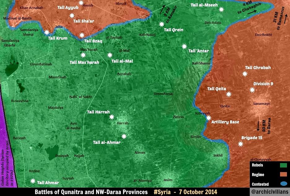
you cant use rebel map for rebel gains, you need pro-gov map pyphonhttps://en.wikipedia.org/w/index.php?title=Talk:Cities_and_towns_during_the_Syrian_Civil_War&action=edit§ion=61# — Preceding unsigned comment added by Pyphon (talk • contribs) 07:25, 8 October 2014 (UTC)
- The map in question shows about a third of Jaba occupied by the rebels, so as much as the map is accurate and up to date, Jaba should be contested.
- BTW, that is not the original source of the map. You should always go to the original source, which in this case is @archcivilians, since other locations could have modified the map. (The source is here.) Note that maps are often modified by third parties without indicating so, according to their understanding of the situation.
- Being posted on twitter is irrelevant : It is not a brief comment without context, but a detailed annotated map. It is just as valid as it would be if posted elsewhere. (In contrast with the vague maps with few details generally found in western media.)
- No map should be used to change control of an area unless it very clear - guessing games do not improve the quality of the WP map. In many cases, locations in close proximity are controlled by another side. André437 (talk) 09:01, 8 October 2014 (UTC)
Morek
Morek taken all or in part by SAA according to tweet from opposition sources https://twitter.com/markito0171/status/519739157669634049. Waiting for confirmation.Paolowalter (talk) 07:28, 8 October 2014 (UTC)
Actually, the same source reported, https://twitter.com/markito0171/status/519757647252176896 so, as of now, Morek stays as it is. — Preceding unsigned comment added by 179.181.92.207 (talk) 09:43, 8 October 2014 (UTC)
- Also the first tweet was deleted. The second report clarifies that Assad forces took control of a tank battalion base north of Morek, and not Morek itself. This is also reported here, claiming regime attempt to encircle Morek. André437 (talk) 10:28, 8 October 2014 (UTC)
- This is actually very bad source. For example, he claimed that rebels are advancing in Adra and few hours later on the contrary the army gained the whole Adra. Or he tweeted ISIS gains in Kobane, that were not true eventually.
Actually, an Islamic Front source https://twitter.com/islamic_front/status/521909469484433408 reported that the front has taken back morek Tank batallion, it should be in green. 20:51, 14 October 2014 (UTC+1)
Southern Aleppo
https://www.facebook.com/syriahroe/posts/593872090721133 SOHR and the neutral Charles Lister:https://twitter.com/Charles_Lister/status/519783029326090240 have reported the rebels seizing all those villages in south Aleppo, in a recent offensive by Ahrar Ash-Sham — Preceding unsigned comment added by 179.181.92.207 (talk) 09:51, 8 October 2014 (UTC)
https://www.facebook.com/cabcs7/posts/783599751683570 Rebel sources sayed the villages of Kashuta, Higher Zaraa, Lower Zaraa, al Barzanaia and Bashkawi had fallen to Ahrar AsSham mouvment. 11:20, 08 October 2014 (UTC+1) — Preceding unsigned comment added by Khalil.aifaoui (talk • contribs)
sohr says rebels capture Qashouta, al-Baraznia, Deman, al-Ezraa and al-Zeraa location: http://wikimapia.org/#lang=tr&lat=36.023488&lon=37.298927&z=14&m=b&gz=0;372562694;359987366;0;289509;319290;485233;376796;273544;823116;131924;799083;0;557041;54161;594806;134701;534725;189547;9441;295757Hwinsp (talk) 11:53, 8 October 2014 (UTC)
I have updated Qashuta, Barzaniyah, Diyman, al-Zaraa, and al-Adnania. Could not locate al-Ezraa, al-Tahtatnia, al-Foukania, or Jam'ia al-Zahraa Boredwhytekid (talk) 13:27, 8 October 2014 (UTC)
Jam'ia al-Zahraa and al zeraa and al-Zeraa al-Foukania is the same. al-Ezraa and el ezra al-Tahtatnia is same too .You should add only al ezra(el ezra al-Tahtatnia).Location: http://wikimapia.org/#lang=tr&lat=36.009499&lon=37.318647&z=16&m=bHwinsp (talk) 13:36, 8 October 2014 (UTC)
- Danke for the insight. I don't see al-Ezra (al-Tahtatnia) at that wikimapia location though. I see Umm Jurn, Zeraa, and Azziraa. Boredwhytekid (talk) 13:41, 8 October 2014 (UTC)
zeraa=al ezra= al-Ezra al-Tahtatnia :)Hwinsp (talk) 13:57, 8 October 2014 (UTC)
Oh. lol. ok so nothing else needs to be added b/c I already updated al-Zaraa. Boredwhytekid (talk) 13:59, 8 October 2014 (UTC)
"neutral charles lister LOL and SOHR" congratulation wikidiots, it was denied by SAA that any village was captured, it gets changed in HOURS if a twitter jihadist fanboy and Sohr claims something WITHOUT any evidence, but when Handarat was taken it took 3 days to update half of it. SHAME. — Preceding unsigned comment added by 89.132.122.57 (talk) 14:28, 8 October 2014 (UTC)
- That same SAA that denied Tabqa airbase fell? That same SANA news that hasn't acknowledged a single rebel advance in 3.5 years? The only reason Handarat took so long was because the individual city maps are do not have as many editors.. Boredwhytekid (talk) 14:39, 8 October 2014 (UTC)
There was videos the next day of the capture, and SAA did not denie the fall. We are talking about ahrar al sham, jihadists who pledged alliance to IS, it is for propaganda to boost moral. Still not a single evidence. — Preceding unsigned comment added by 89.132.122.57 (talk) 17:32, 8 October 2014 (UTC)
- SANA described the fall of Tabqa, and I quote their English site, "Our forces have completed a successful regrouping operation after withdrawing from the air base and they are still carrying out precision strikes against the terrorist groups in the area." Boredwhytekid (talk) 17:43, 8 October 2014 (UTC)
- These changes need to be reverted. SOHR is pro-rebel and NOT a neutral source, therefore their reports can not be used to confirm rebel gains.--CommieMark (talk) 21:06, 9 October 2014 (UTC)
- Obviously you need to read the WP guidelines. Paraphrasing the guidelines, it is not the preferred outcome of the reporter that counts, but the reliability of the reporting. In terms of reliability, SOHR is one of the most accurate sources, their errors generally being that of omission (not reporting changes right away), particularly in the south (Daraa, Quneitra), where they seem to have fewer sources on the ground.
- As far as sources being pro-rebel, that is a claim often made here about sources who have close contacts with the rebels. Any neutral sources reporting on rebel activity would necessarily have contacts with the rebels. SANA obviously doesn't, being a party directly in conflict with the rebels. (Which disqualifies it from being a reliable source for regime advances, both logically and according to WP policy.)
- BTW, I don't know why some persist in claiming that ahrar al-sham is associated with the IS/ISIS/Daesh. They are part of the Islamic Front which is fighting the ISIS, nor are they jihadists. Just because a few of their fighters are reported to have deserted to the ISIS doesn't make them ISIS. By that argument, the US, UK, and France are all ISIS and jihadist. Obvious nonsense. — Preceding unsigned comment added by André437 (talk • contribs) 10:02, 10 October 2014 (UTC)
Charles Lister, a neutral and very reliable source, confirmed the advances. And SOHR is widely considered reliable by pretty much all news outlets all over the world — Preceding unsigned comment added by 179.179.158.54 (talk) 00:33, 10 October 2014 (UTC)
- SOHR is not considered reliable as it is openly supportive of one side. It doesn't matter if some western news sites cite it. It is run by some guy living in an apartment in Coventry, England. Not a single reliable source is reporting what some editors are trying to portray as a large advance. This is ridiculous. Until a verifiable source is cited the changes should be reversed --46.7.83.115 (talk) 02:15, 10 October 2014 (UTC)
- Something you do not understand about this map, not only is SOHR ironically reliable, it is the "bible" of the civil war. Its word is taken above all and most edits to this map are made based on SOHR [around 80%], so every time you come here, you are looking at a SOHR map if SOHR ever made one. Editors will justify by saying that SOHR has reported accurately, but many of those same people will shoot down sources like Al-Masdar. Even though it has also reported accurately, it is run by a regime sympathizer and is not reliable. Ironic, isn't it? As for trying to get SOHR removed, do not bother. A consensus was established years ago and all attempts to challenge have thus far been ignored. 2602:30A:C01B:89F0:4C1F:A767:8E14:8CED (talk) 03:06, 10 October 2014 (UTC)
- SOHR is not considered reliable as it is openly supportive of one side. It doesn't matter if some western news sites cite it. It is run by some guy living in an apartment in Coventry, England. Not a single reliable source is reporting what some editors are trying to portray as a large advance. This is ridiculous. Until a verifiable source is cited the changes should be reversed --46.7.83.115 (talk) 02:15, 10 October 2014 (UTC)
- Every time this comes up, the only reasoning given for limiting the use of SOHR is that "it's pro-op!". No one ever posts examples of it's inaccuracy, or proof of its unreliability. Show me. Show me that SOHR reports are wrong more than they are right. Show me an SAA advance that was not reported by SOHR. You're right, rants about the green flag in the background of the SOHR never go anywhere - but that's not because of pro-rebel bias, it's because no logical, empirical evidence is given to discredit SOHR's reports of battlefield gains/loses. Stealing from Andre: "Paraphrasing the (WP) guidelines, it is not the preferred outcome of the reporter that counts, but the reliability of the reporting" Boredwhytekid (talk) 13:58, 10 October 2014 (UTC)
- "The Aleppo Central Prison is now in Rebel Hands!"" Rebels have recaptured Al-Burj roundabout and foiled army plans to lift siege of Aleppo central prison!""Latakia City struck by Grad Missiles!" There are some right there. And to your point about "Show me that SOHR reports are wrong more than they are right", how come you reject Al-Masdar. They have been right about almost everything so far, yet they are unreliable? Why is that? 2602:30A:C01B:89F0:4C1F:A767:8E14:8CED (talk) 21:23, 10 October 2014 (UTC)
al-Adnania and al-Safirah, Aleppo
Ok. As the map currently stands, al-Adnania is contested. This edit was based off of the SOHR main page and this is also widely reported on twitter (secondary sources, of course) here and here just to note a few. Also, al-Safirah has a lime ring to the SW based off of this SOHR post - the post claims clashes "in" Safirah, but that may be a typo, and Safirah is far too large and strategically important to have its status changed to contested based off of 1 SOHR post. I think this is suitable for the time being, given the fluid situation on the front line in this area. Just kinda throwing this up on the talk page so everyone can comment/complain/debate/provide additional sources for affirmation or refutation of said situation. Cheers. Boredwhytekid (talk) 19:58, 8 October 2014 (UTC)
I hardily think the rebels have reached Al-Safira as the way to the city is blocked by the defense factories west of it.May opinion is that SOHR is either trying to boost a little propaganda(not unusual for them) or they had just translated a statement from the rebels.But please keep an eye on this situation as many times the Army recaptures this villages without SOHR or any other neutral source reporting and the all off a sudden we find reports of fighting way deep into rebel lines as many editors on Wiki refuse to take into account making changes based on pro-gov sources.As many previous offensives that were lunched by the rebels turned out to be only temporary to relive pressure from another front(Handarat) and then simply vanish(Hama,Latakia,Dokhaniya) from the from the front line and the Army takes back ground that it has lost. Daki122 (talk) 20:47, 8 October 2014 (UTC)
I agree with Boredwhytekid. It was most probably a typo, because all other SOHR reports about fighting on that front are reporting only clashes in the villages near the town, not the town itself. And at the moment, fighting is concentrated in al-Adnania. EkoGraf (talk) 20:49, 8 October 2014 (UTC)
- Further SOHR posts about fighting around Adnaneyyi (Adnania). A SOHR post of clashes in the defense factories. Boredwhytekid (talk) 12:16, 9 October 2014 (UTC)
Clashes in the area of the factories not in the factories.Just to correct you.Daki122 (talk) 13:43, 9 October 2014 (UTC)
Yup - I marked the lime presence around the factories, didn't mark them contested :) Boredwhytekid (talk) 14:12, 9 October 2014 (UTC)
From http://www.almasdarnews.com/article/syrian-army-captures-west-handarat-farms-babinnis-ahrar-al-sham-offensive-safira-repelled/, that is reliable reporting regularly also government losses, all the lost villages were taken back by SAA.Paolowalter (talk) 21:11, 9 October 2014 (UTC)
- This was actually expected. I believe this is the third time rebels have tried to cut this supply line. This offensive was clearly an ill coordinated attempt to relieve pressure off Handarat, therefore it does not shock me that the villages were recaptured so fast. 2602:30A:C01B:89F0:4C1F:A767:8E14:8CED (talk) 22:15, 9 October 2014 (UTC)
Firstly,Al-Masdar is an unreliable source,and all of us knows whom is the editor in chief of it,secondly,this current rebel offensive on the supplyline looks to be planned accordingly and planned monthes away,thirdly,why where villages in Latakia turned read with an unreliable source like Al-Masdar.Alhanuty (talk) 22:40, 9 October 2014 (UTC)
- You seem to have a literacy problem. Have I not already proven to you that your argument, where you trash the editor in chief of Al-Masdar, to be wrong. For the last time, if you want to work on editor affiliation, SOHR is banned because its editor is openly pro-opp. How many times do I have to explain this to you? Second, how do you know that "looks to be planned accordingly and planned monthes away". Do you have contacts with the rebels by any chance? Reliable sources are determined by thier accuracy record and so far, Al-Masdar has been accurate. So Al-Masdar is a reliable source. 2602:30A:C01B:89F0:4C1F:A767:8E14:8CED (talk) 01:18, 10 October 2014 (UTC)
Al-Masdar is not reliable. It's a pro-regime source. Actually, it reported Tell Al-Harrah to be regime held, even with some 100 sources saying otherwise. Not SOHR, not ANY reliable media reported ANY regime regaining those villages. Should the regime retake then, we will know — Preceding unsigned comment added by 179.179.158.54 (talk) 00:16, 10 October 2014 (UTC)
- It reported the first attack to be repelled. Rebels attack again later and took the hill per: https://twitter.com/EjmAlrai/status/518897087644041216 2602:30A:C01B:89F0:4C1F:A767:8E14:8CED (talk) 01:18, 10 October 2014 (UTC)
- It has been discussed many times and nobody has ever brought a proof that Al-Masdar is not reliable. It reports regularly gain and loss on each side. I updated the map based on tis info. A couple of villages behind the lines remains green temporarily for lack of information.
If no further news arrive, I'll change them to red later.Paolowalter (talk) 07:14, 10 October 2014 (UTC)
You will change them to red if you provide a source stating as such. Until then, they remain as is. — Preceding unsigned comment added by 146.185.36.35 (talk) 09:08, 10 October 2014 (UTC)
No, Al-Masdar has NOT said anywhere that the rebels have taken Tell Al-Harrah. It said they repelled a attack(which is a lie) and ignored all other proofs. Any source that does this=NOT RELIABLE. Your pro-regimeness is getting you to ignore what's a good source and what is not. If we where to believe in Al-Masdar, we we're supposed to change this whole map to red, since it reports RARELY minor rebel gains. I mean, the rebel advances in Daara and Quneitra(big advances) are being ignored, while in Eastern Ghouta, Aleppo(now the rebels advance in the south and the regime did not retake those villages), Hama, where the regime is advancing they report any single advance, sometimes reporting the same advance twice, without mentioning that the rebels retook some territory(such as Dukhania, where the rebels took control after never holding it, regime took it back according to Al-Masdar, but a week later the regime took it back AGAIN, this time with SOHR and other sources confirming it). In Quneitra, they actually claimed the regime to be advancing, taking Naba al-Shaker, but hey, guess what, the rebels never had held in the first place, and the other day the rebels actually took it. Just the mistakes in Daara and Quneitra makes it EXTREMELY unreliable. — Preceding unsigned comment added by 179.179.158.54 (talk) 09:51, 10 October 2014 (UTC)
- This particular almasdarnews.com article starts with the preposterous phrase "The civilian-led National Defense Forces (NDF) ...", and goes on to use typical biased SANA terminology. It has all the appearances of propaganda. It also says the report is based claims of regime forces, so it can't be any more reliable than direct regime claims. (Re-read the article if necessary, this point should be obvious.)
- It should not be accepted as a reliable article, without collaborating evidence. That without any consideration of the source's general track record André437 (talk) 10:39, 10 October 2014 (UTC)
- You seem to be completely lost not only regarding Wikipedia policy, but on this war as well. The NDF is made up of Syrian civilians. It is like a national guard. I did not even think that was in dispute. As for biased terminology, how many "martyrs" died when "Islamic battalions liberated" an area? 2602:30A:C01B:89F0:4C1F:A767:8E14:8CED (talk) 20:13, 10 October 2014 (UTC)
- You are just proving that you have never read WP policy. Or have a very short memory, if not incapable of understanding it. As far as the war goes, I've been following it almost since the beginning, and following the Syrian dictatorship generally for over 10 years.
- Claiming that the NDF is like a national guard is admitting that it is a government led military organisation. You say it is made up of civilians. Before they enroll maybe, but while they serve they are military personnel, not civilians. Your comments suggest that you have read "1984" or "Animal farm" (by George Orwell) a few too many times.
- As well, you haven't addressed the fact that the article claims the regime military as its' source.
- Although SOHR does sometimes use biased language, which could bring such an article into question, their articles generally use unbiased language and are corroborated later by other sources. This article, as well as using consistently biased language, contradicts numerous other sources available André437 (talk) 07:54, 11 October 2014 (UTC)
Almasdarnews has never been acceptable as a primary source for this map. It's equivalent to Orient news for the rebels. Not sure where anyone is getting a different idea about it. Boredwhytekid (talk) 12:55, 10 October 2014 (UTC)
- But Boredwhytekid, I thought you said that a source can be used if it has a reliable record. All of Al-Masdars reporting in hama and Damascus has been reliable. It must get the "SOHR treatment" and be allowed to edit the map. After all, SOHR is still a reliable source even after reporting inanities like the fall of the Aleppo Central Prison 2602:30A:C01B:89F0:4C1F:A767:8E14:8CED (talk) 20:13, 10 October 2014 (UTC)
Where are the neutral, primary scources then, guys ? SOHR displays a huge FSA style-flag on Facebook and it's homepage, and are you calling it reliable, independent scource ? Oroszka
- Grasping at straws to discredit the SOHR : Prematurely reporting the fall of the central prison after the rebels did enter the outer courtyards only to be repelled by regime bombardment was the only major error by SOHR in over 3 years. Displaying the independence flag does not mean SOHR reporting is biased. Sites that display the regime flag don't necessarily support the Assad dictatorship which adopted it in 1980.
Note that the SOHR has erred more in delayed reporting of rebel advances.
Al-Masdar is a very unreliable source,and why where those villages changed with a biased and unreliable source such as Al-Masdar,the pro-Government map maker Keepingtheleith is literally the editor in chief of Al-Masdar,this source should never be used to report government gains.Alhanuty (talk) 17:36, 10 October 2014 (UTC)
- At this point, I believe you are trolling. I already explained to you that Rami Abdullrahman is a pro-opp writer. So SOHR will never gain be used to report opposition gains rights? No, of course not, because SOHR has a "golden ticket"! You only want to apply your logic where it benefits you. It matters that Al-Masdar's writer is biased but not that SOHR writer is biased? 2602:30A:C01B:89F0:4C1F:A767:8E14:8CED (talk) 20:13, 10 October 2014 (UTC)
- There is consistent evidence that SOHR is not biased in its' reporting. If anyone is trolling, it is you André437 (talk) 07:54, 11 October 2014 (UTC)
Douma
Government forces captured Rayhan in the Douma outskirts there are vidoe and photo evidence of the advancement:
-https://twitter.com/IvanSidorenko1/status/519998427506434048 -https://twitter.com/IvanSidorenko1/status/519998595358289920 -https://www.youtube.com/watch?v=KNcvE_uECew&feature=youtu.be Update the map when you can.Daki122 (talk) 13:50, 9 October 2014 (UTC)
You know that we cannot use twitter info except for maps of some users. (Even if I believe the info) Paolowalter (talk) 21:11, 9 October 2014 (UTC)
- One more source mentioned it, albait not a major/reliable one. Though it sounds probable, I'd suggest we wait on this edit. http://www.reddit.com/r/syriancivilwar/comments/2ip7sd/recap_on_what_the_syrian_arab_army_captured_in/ — Preceding unsigned comment added by 62.231.150.132 (talk) 10:08, 10 October 2014 (UTC)
Confirmed by http://www.almasdarnews.com/article/syrian-republican-guard-liberate-al-rayhan-liberation-jobar-coming/Paolowalter (talk) 12:28, 11 October 2014 (UTC)
Morek
Just something to keep an eye on: pretty much every pro-op news outlet is reporting that the rebels retook the tank battalion in northern Morek 1 2 3 4 5, and the pro-op syriadirect update for today's date (can't link - it's blacklisted) Boredwhytekid (talk) 17:33, 9 October 2014 (UTC)
- It is very common for rebel outlets to issue what I call "retractions". Essentially what that means is that the rebels will state that they have regained an area shortly after losing it to minimize psychological impact on themselves. We have seen this in Handaarat, Dukhanniya, Khitab, and Al-Burje roundabout [Aleppo under Central Prison] to name a few. 2602:30A:C01B:89F0:4C1F:A767:8E14:8CED (talk) 20:17, 9 October 2014 (UTC)
- The rebels loosing and regaining the tank battalion base north of Morek has been reported by the ISW (Institute for the Study of war). It should be considered a neutral and reliable source. The same group also reports (more frequently) on the conflict in Iraq.
- BTW, it is easy for inexperienced observers to imagine the front lines are fairly static, but that is not how wars are fought. It is very common for advances by one side to be quickly reversed.
- This has happened in Handarat (rebels regaining, noted in the ISW report above), Dukhaniya (regime regained territory they effectively admitted having lost), etc. André437 (talk) 04:49, 12 October 2014 (UTC)
Um
Alhanuty , you changed Judayyah to contested based off of this, which says clashes around, not in - and we already had a green circle around Judayyah. You changed Simlin to green based on the same post. Simlin is on the front line. Not sure how you gathered it was rebel-held from that post. You changed Nimer to rebel-held based off of this and with the reasoning that "makes no sense that it (SAA) still controls it after the fall of tal-harra" - all fine and dandy, but "common sense" edits without sources require community consensus, which you did not even try to obtain. Boredwhytekid (talk) 12:50, 10 October 2014 (UTC)
My edits were based on reliable SOHR reports,for Nemer it reports bombardment on the town,and it is deep in rebel territory.Alhanuty (talk) 13:28, 10 October 2014 (UTC)
also,the reports talked about heavy Bomdardment for both Simlin and Nemer,and it doesn't make sense for government forces to heavily bombard a town,if they still have troops there.Alhanuty (talk) 13:29, 10 October 2014 (UTC)
Yes, reliable SOHR reports, but you misrepresented them. Again, that source says nothing about fighting IN Judayyah. Nothing at all. And Simlin has been both bombarded and contested by both sides for over a week. It is on the front line. Nimer is behind rebel lines, yes, but no sources say it's rebel held (I too believe it to be rebel held, but that is not of consequence). If reports of bombardment continue, and if no reports of fighting/besieging Nimer are found, and if you put the issue before all the editors here on the talk page - then, Nimer may be made rebel-held. Since when has it been ok to make unsourced edits without a community consensus? Boredwhytekid (talk) 13:39, 10 October 2014 (UTC)
Jadia=Judayyah,Silmin doesn't look to be on the frontline,the frontline moved westwards,and there is literally multiple reports of bombardment on simlin.Alhanuty (talk) 14:21, 10 October 2014 (UTC)
- Jadia=Judayyah? The post still doesn't say anything about fighting in that town. And, Simlin isn't on the front? Look at it - it's right next to SAA held Brigade 15 and Sanamein! Not to mention the situation in Simlin itself isn't even verified! The SAA bombards towns that it has troops in all the time. Morek. Zabadani. Nawa. al-Karak. Bosra. Damascus! Daraa. Deir el Zor. Aleppo.... Simlin. Boredwhytekid (talk) 14:31, 10 October 2014 (UTC)
it says in Jadia area.Alhanuty (talk) 14:57, 10 October 2014 (UTC)
Hence the green circle around Judayyah. Boredwhytekid (talk) 15:15, 10 October 2014 (UTC)
Tall Shair
Reliable sources reporting that this hill was retaken by ISIS [12]. Also fits with common sense, as it seems unlikely that the YPG are holding an outpost like that significantly outside Kobane as the situation is so dire that their headquarters in the city just fell.Nhauer (talk) 13:59, 10 October 2014 (UTC)
![]() Done Boredwhytekid (talk) 14:03, 10 October 2014 (UTC)
Done Boredwhytekid (talk) 14:03, 10 October 2014 (UTC)
- SOHR reports this as well Boredwhytekid (talk) 14:11, 10 October 2014 (UTC)
Kissin-North Homs (houla plain)
new Pro opp map shows kissin under saa controll source: http://i.imgur.com/C7P9PZr.jpgHwinsp (talk) 08:29, 11 October 2014 (UTC)
This is no source, this is a second-hand Twitter map from an unknown source. We don't use Twitter sources and maps, not even pro-SAA maps. — Preceding unsigned comment added by 84.24.43.183 (talk) 09:16, 11 October 2014 (UTC)
map is from Revolution in Homs media (pro opp)Hwinsp (talk) 11:20, 11 October 2014 (UTC)
Sadaya (South Aleppo)
Sohr says rebels captured sadaya: http://syriahr.com/index.php?option=com_news&nid=24832&Itemid=2&task=displaynews#.VDj6pfmsWQmHwinsp (talk) 09:40, 11 October 2014 (UTC)
By the way, saa sources say saa recaptures 5 villages around defence factories. https://www.facebook.com/hosienmortadapressnew/posts/976608189031347:0 https://www.facebook.com/Manqolmnn/posts/706345019459455 .I think we should waitHwinsp (talk) 10:04, 11 October 2014 (UTC)
No they didn't. First, reliable sources in this are foreign analists and media. SOHR is only considered because it always reports regime advances and is considered a reliable source by many medias such as Reuters. Once SOHR or other media reports the regime advances, we use them(oh, and for the ones saying Masdar is reliable, they still haven't admited Tell al-Harrah to be rebel held, despite dozens of sources claiming otherwise, including international media and youtube videos on top of the hill) — Preceding unsigned comment added by 179.181.84.171 (talk) 11:12, 11 October 2014 (UTC)
Offical saa sources says , saa recaptures bash kuy - quashutah - dıyman - al zeraa -adnanıyah and umm jurn.We should wait pro opp sources to confirmed it https://www.facebook.com/addounia.channel/posts/753681931358465 https://www.facebook.com/syria.net/posts/740456386009707Hwinsp (talk) 11:17, 11 October 2014 (UTC)
The problem with SOHR is that sometimes it does not report take over of rebel held villages by the Army(the small ones like in this case) and many times it goes unnoticed until some analysis from neutral media which takes about a month or so.Last time south Aleppo was changed we had to put a dozen villages to red form green after a month of their take over.That is why I say we keep an eye on the situation and wait either for conformation from neutral sources or at least credible video evidence.Daki122 (talk) 13:12, 11 October 2014 (UTC) SOHR only reports saa advances after other outlets report it.it makes him look reliable source sitting in his London apartmentPyphon (talk) 15:53, 11 October 2014 (UTC)pyphonPyphon (talk) 15:53, 11 October 2014 (UTC)
Wadi Ayn Termah
The news reports say that this area in rif dameshqe was captured by SAA:MZarif (talk) 12:03, 11 October 2014 (UTC)
http://www.almayadeen.net/news
Also Petolucem posts it, he's reliable https://twitter.com/PetoLucem/status/520889603721818113 — Preceding unsigned comment added by SyAAF (talk • contribs) 13:56, 11 October 2014 (UTC) You have to wait for SOHR to post it. Its his map now don't you know.Pyphon (talk) 16:01, 11 October 2014 (UTC)pyphon
SOHR reported advances [13]
While Danny Makki [14] who is a political analyst for Syria(Had seen him on RT and Al-Jazeera) also said that it has been retaken.Daki122 (talk) 18:48, 11 October 2014 (UTC)
See also http://www.almasdarnews.com/article/syrian-army-liberates-vital-city-east-ghouta/.Paolowalter (talk) 18:56, 11 October 2014 (UTC)
SOHR at his best making a saa gain lock like a defeat oh such reliabilityhttps://en.wikipedia.org/w/index.php?title=Talk:Cities_and_towns_during_the_Syrian_Civil_War&action=edit§ion=67# — Preceding unsigned comment added by Pyphon (talk • contribs) 20:00, 11 October 2014 (UTC)
SAA captured wadi ayn tarma source: https://www.facebook.com/syriahroe/posts/595755190532823 LOCATION: http://wikimapia.org/#lang=tr&lat=33.505761&lon=36.357365&z=15&m=b&gz=0;363349628;334950430;24032;158349;78535;134912;145912;127755;196552;164432;254917;152803;297832;127397;342464;30061;282382;0;0;103422;27465;157813 Damascus map shows as contested.We should fix the map.ThanksHwinsp (talk) 08:36, 12 October 2014 (UTC)
Confirmed by SOHR https://www.facebook.com/syriahroe/posts/595755190532823.Paolowalter (talk) 12:05, 12 October 2014 (UTC)
TEL AL HARRAH
According to the Jerusalem post the rebels have just taken TEL AL HARRAH signal post.That must mean the saa are still in al harrah. Once again you have presumed to much to fast https://en.wikipedia.org/w/index.php?title=Talk:Cities_and_towns_during_the_Syrian_Civil_War&action=edit§ion=new# — Preceding unsigned comment added by Pyphon (talk • contribs) 16:16, 11 October 2014 (UTC)
Tel al Harrah may be green but Harrah is at least contested. Please change it to contested. http://www.almasdarnews.com/article/200-jabhat-al-nusra-fighters-killed-tal-hamra/ reports up to yesterday fighting in Tel al Harrah, recongnizing advance of the rebels but deniying it has been completely taken. Paolowalter (talk) 18:56, 11 October 2014 (UTC)
- Paolowalter and others : please don't start a line with a space, it causes special formatting. (I just fixed the format of your post.) For indentation use ":". (Multiple times for more indentation.)
- Also, please use the preview button to see what your post looks like. Thanks :) André437 (talk) 23:05, 13 October 2014 (UTC)
Nonsense, and an old source. Rebels control Harrah town. It was said so by multiple media outlets. In fact, rebels control Nimr and the red towns in Quneitra (south) also :) but as usual, this map is three weaks behind the actual events in Daraa and Quneitra. — Preceding unsigned comment added by 84.24.43.183 (talk) 19:49, 11 October 2014 (UTC)
- Parrot effect, only SOHR truly reported. And do you have proof of "In fact, rebels control Nimr and the red towns in Quneitra" or are you one of those whiners that consistently complain about how the rebels have taken Damascus yet have no proof to show for it? 2602:30A:C01B:89F0:4C1F:A767:8E14:8CED (talk) 20:02, 11 October 2014 (UTC)
- I agree Paolowalter al harrah back to red ;)Pyphon (talk) 20:14, 11 October 2014 (UTC)pyphonhttps://en.wikipedia.org/w/index.php?title=Talk:Cities_and_towns_during_the_Syrian_Civil_War&action=edit§ion=68#
- I disagree. Despite the fact that there is still fighting in Tel-Harra, I think both tel-Harra and Harra town should be contested to restore the map to normalcy after it was disrupted by what appears to have been a rebel propaganda tsunami (Nimir, Zimirin, Tell-Harra, Harra were all victims). 2602:30A:C01B:89F0:4C1F:A767:8E14:8CED (talk) 22:23, 11 October 2014 (UTC)
Even Iranian Television reports Harrah is rebel held. Boredwhytekid (talk) 14:47, 13 October 2014 (UTC)
Aleppo north
Bashkuy contested according to pro-opp www.facebook.com/AMCenglish/posts/526980007439424. http://wikimapia.org/#lang=en&lat=36.327020&lon=37.120743&z=14&m=b Paolowalter (talk) 16:33, 11 October 2014 (UTC)
Is against the rules used pro beheaders sourses to showing beheaders advances link something more neutral pls. — Preceding unsigned comment added by 190.203.140.28 (talk) 20:45, 11 October 2014 (UTC)
- You do realise that the biggest "beheaders" are the Assadist cluster bombers. They shred the victims in the process. Compared to the regime, the ISIS are amateurs. André437 (talk) 05:41, 12 October 2014 (UTC)
- Wikipedia is no place for your propaganda. And this statment here: "Compared to the regime, the ISIS are amateurs" reveals how horribly ignorant you really are about what happening there. 2602:30A:C01B:89F0:4C1F:A767:8E14:8CED (talk) 16:28, 12 October 2014 (UTC)
- You do realise that the biggest "beheaders" are the Assadist cluster bombers. They shred the victims in the process. Compared to the regime, the ISIS are amateurs. André437 (talk) 05:41, 12 October 2014 (UTC)
- Paolowalter is trying to show an SAA gain through the pro-opp Aleppo Media Centre, which is allowed. It really does not get any more pro-opp then that. 2602:30A:C01B:89F0:4C1F:A767:8E14:8CED (talk) 22:31, 11 October 2014 (UTC)
This is not about politics, andre gtfo. The only beheaders are the ones who post their beheading by the hundreds, IF,nusra,FSA etc
Also SOHR confirms SAA is already near the infantry school north to Aleppo https://www.facebook.com/syriahroe/posts/595842903857385?fref=nf confirming Peto Lucem's map showing that Babinnis was taken several days ago. https://twitter.com/PetoLucem/status/520278356412354561/photo/1 — Preceding unsigned comment added by 89.132.122.57 (talk) 09:04, 12 October 2014 (UTC)
South Aleppo
Saa advancing in southern aleppo and recapture sadaya according to sohr: http://www.syriahr.com/index.php?option=com_news&nid=24851&Itemid=2&task=displaynews#.VDmPj_msWQkHwinsp (talk) 20:18, 11 October 2014 (UTC)
- Regime Afghan mercenaries? Seriously? Nevertheless, the "Almighty SOHR" has spoken, back to red. 2602:30A:C01B:89F0:4C1F:A767:8E14:8CED (talk) 22:26, 11 October 2014 (UTC)
- More constructive commentary eh? Afghan mercenaries - Vice News al-Arabiya Washington Institute Foreign Policy Fox News Wallstreet Journal Really man, you do nothing but bash SOHR but don't even put forth the effort run a simple google search to see if there's any justification for their claims. Boredwhytekid (talk) 14:54, 13 October 2014 (UTC)
SOHR confirmed the regime to have taken all the villages they lost in the Ahrar ash-Sham offensive. http://syriahr.com/en/2014/10/regime-forces-advance-in-aleppo-countryside-and-rebels-advance-in-aleppo-city/
Also, Suleiman Halabi district need to be contested, the rebels control more then half of it already — Preceding unsigned comment added by 179.181.84.171 (talk) 12:52, 12 October 2014 (UTC)
And I'm living on the moon. Suleiman Halabi to contested(but it is so small I doubt it will be significant on the map).
- You better to stay there.--Zyzzzzzy (talk) 04:43, 13 October 2014 (UTC)
- Do you have reliable sources? If not, then no status change. — Preceding unsigned comment added by 2602:30A:C01B:89F0:4C1F:A767:8E14:8CED (talk) 16:26, 12 October 2014 (UTC)
ALEPPO
saa repelled rebels offensive and SAA recaptures vilages in south aleppo (abu tabbah -qastunah- dıyman -barzanıyah - al zaraa -adnanıyan -umm jumm) accordin to sohr: http://syriahr.com/index.php?option=com_news&nid=24866&Itemid=2&task=displaynews#.VDpuVfmsWQlHwinsp (talk) 12:08, 12 October 2014 (UTC)
LOCATION: http://wikimapia.org/#lang=tr&lat=36.026403&lon=37.301159&z=13&m=b&gz=0;372560119;359961325;236892;705213;0;263140;259208;218017;767326;0;858306;91657;830841;284660;444602;433198;259208;731577;214576;667748Hwinsp (talk) 12:12, 12 October 2014 (UTC)
translation from sohr eng: http://syriahr.com/en/2014/10/regime-forces-advance-in-aleppo-countryside-and-rebels-advance-in-aleppo-city/Hwinsp (talk) 12:19, 12 October 2014 (UTC)
![]() Done Daki122 (talk) 15:19, 12 October 2014 (UTC)
Done Daki122 (talk) 15:19, 12 October 2014 (UTC)
- That SOHR post doesn't specify a single town by name. Boredwhytekid (talk) 13:20, 13 October 2014 (UTC)
http://i.gyazo.com/60acf43a035cd97fed8734b9c8a5b5fc.png according to this map the cities of Rasm-al-safa and kafr Akkar are rebel held as well as Haddadin and al-wadihi on the border of the Aleppo map Edit: Kafr Abid and Balas are reported as theirs as well.
- That is a Pro-opp map and cannot be used to turn towns green. 2602:30A:C01B:89F0:4C1F:A767:8E14:8CED (talk) 22:52, 12 October 2014 (UTC)
SOHR confirms again SAA is near Aleppo infantry school fighting at the cement factory, https://www.facebook.com/syriahroe/posts/596416670466675?fref=nf
Babinnis was taken almost a week ago https://twitter.com/PetoLucem/status/520278356412354561/photo/1 — Preceding unsigned comment added by 89.132.122.57 (talk) 09:20, 13 October 2014 (UTC)
http://syriahr.com/en/2014/10/al-nusra-and-the-battalions-have-advanced-in-handarat-and-sifat-areas/ SOHR confirms rebels to have besieged regime fighters in Sifat and Handarat villages. Also, would you guys stop saying the regime has rebel held Aleppo under siege, because there's another road going into rebel held Aleppo, the Castello road. It's under a half-siege, because it's much harder for rebels to use the road, but it's not under full siege. — Preceding unsigned comment added by 179.177.197.133 (talk) 15:17, 13 October 2014 (UTC)
Idiot Castello road is the main suplly route not the "another"
SOHR reported fighting in Handarat area and sifat nothing about besieged please thankyou https://en.wikipedia.org/w/index.php?title=Talk:Cities_and_towns_during_the_Syrian_Civil_War&action=edit§ion=58#
- Multiple sources have stated that control of Handarat for the SAA is a siege on rebel held Aleppo. Also, there is not way rebel fighters can besiege the SAA in those areas, since the SAA controls the area immediately east of them. Also your sources says "Could" cut them off. Finally, these unspecified "advances" are the essential equivalent of SANA propaganda, this time being done by SOHR in favor of the rebels. As for your arguments about other roads, you are absolutely right. The rebels could trek anywhere they wanted to to deliver supplies, they do not even have to use a road. However, the easy rebel supply line has been eliminated. The rebels can no longer obtain supplies quickly, thus placing them effectively under siege. 2602:30A:C01B:89F0:4C1F:A767:8E14:8CED (talk) 20:07, 13 October 2014 (UTC)
- Just because the 2 main highways from Turkey are blocked at one point (one at al-Zaraa and the another at Handarat) doesn't mean the rebels are incapable of using paved secondary roads to bypass the blockages. If the regime can do the same elsewhere (or worse, building a road through the desert to Khanisir when the rebels blocked the m5), why not the rebels ? It just means the supplies take a little longer to arrive. You just have to look at google maps (or wikimapia) to see the alternative routes. André437 (talk) 23:27, 13 October 2014 (UTC)
http://www.al-monitor.com/pulse/originals/2014/10/aleppo-syria-rebels-face-islamic-state-regime.html — Preceding unsigned comment added by 94.102.233.227 (talk) 09:37, 15 October 2014 (UTC) http://www.presstv.ir/detail/2014/10/15/382338/syria-army-makes-gains-near-aleppo/ — Preceding unsigned comment added by 78.155.46.49 (talk) 19:33, 15 October 2014 (UTC)
Harrah town sources
Some pro-SAA guys have changed Harrah to contested. So here are the sources to make it nice and green again:
1. http://www.longwarjournal.org/threat-matrix/archives/2014/10/free_syrian_army_continues_to.php 2. https://www.facebook.com/syriahroe/posts/595045263937149 3. http://eaworldview.com/2014/10/syria-daily-islamic-state-takes-key-hill-near-kobane/ 4. http://sherifazuhur.wordpress.com/2013/07/27/syria-update-july-26-2013-institute-of-middle-eastern-islamic-and-strategic-studies-by-sherifa-zuhur/ 5. http://mehriran.tv/article_read.php?a=605
So :) green please. Also, we should make the two town in southern Quneitra green. There has been no report of fighting there, and its way behind SAA lines. — Preceding unsigned comment added by 84.24.43.183 (talk) 21:03, 12 October 2014 (UTC)
- All of your sources are A) Pro-Opp or B) Unknown and therefore not authoritative. Please find a neutral source. Per RT: https://twitter.com/HebaDelacres/status/520819121055756289 ongoing fighting in Tel-Harra. Area is not as rebel dominated as some pro-opp editors would like us to believe.2602:30A:C01B:89F0:4C1F:A767:8E14:8CED (talk) 21:09, 12 October 2014 (UTC) 2602:30A:C01B:89F0:4C1F:A767:8E14:8CED (talk) 21:06, 12 October 2014 (UTC)
My God ... longwarjournal is a neutral source, and we agreed to use SOHR. And you deny all that and give me a twitter source? While we all agreed not to use Twitter? This is the best joke I've seen since a few days. Maybe we should also make Jasim, Inkhil and all of Quneitra red again? The godly SAA is advancing steadily, right? I'm sure I can find a Twitter source or map claiming the SAA is already storming Israel itself :,) — Preceding unsigned comment added by 84.24.43.183 (talk) 08:47, 13 October 2014 (UTC)
Bombardment of tel Harrah https://www.facebook.com/syriahroe/posts/595758763865799. ISW "rebel forces... seize the town of Tel al-Hara" Boredwhytekid (talk) 13:08, 13 October 2014 (UTC) Ok so tel al harrah hill is in rebel hands and the saa are bombarding hill.That means the saa must be in the area . But according to this map they are nowhere near. https://en.wikipedia.org/w/index.php?title=Talk:Cities_and_towns_during_the_Syrian_Civil_War&action=edit§ion=59# — Preceding unsigned comment added by Pyphon (talk • contribs) 14:00, 13 October 2014 (UTC)
- Artillery shoots a long way. And "bombarding" can also mean aerial bombardment. Boredwhytekid (talk) 14:02, 13 October 2014 (UTC)
Its a yery long way according to this map Kafr shams is the nearest place and as for aerial well the best the saaf has managed up to now is the odd air strike hardly a bombdardment ;)https://en.wikipedia.org/w/index.php?title=Talk:Cities_and_towns_during_the_Syrian_Civil_War&action=edit§ion=59# — Preceding unsigned comment added by Pyphon (talk • contribs) 14:21, 13 October 2014 (UTC)
Syria is a small country, Daara is a small province and the distance from Kafr Shams to Harrah town is, using the roads, 16km. Artillery doesn't use roads and it's not inside Kafr Shams, but on the outskirts. Most likely some 5/6km from the Harrah town, and for modern artillery, that distance is nothing — Preceding unsigned comment added by 179.177.197.133 (talk) 15:11, 13 October 2014 (UTC) The report did say aerial bombard and one rebel killedPyphon (talk) 15:21, 13 October 2014 (UTC)pyphon https://en.wikipedia.org/w/index.php?title=Talk:Cities_and_towns_during_the_Syrian_Civil_War&action=edit§ion=59#
After all these discussion no reliable source about Harra controlled by rebels has shown up. All sources (most unreliable) referes to Tell Harra the hill not the city. Therefore Harra stays at least contested. Do not invent a non existing consensus on Harra green, I do not agree.Paolowalter (talk) 19:12, 13 October 2014 (UTC)
- Even Iranian news says Harra is rebel held. Boredwhytekid (talk) 19:29, 13 October 2014 (UTC)
- From the many videos available it is evident that any party that controls the base on the hill overlooking the town controls the town. The town is almost under the base. As well, there are videos showing rebels in the town. One amusing one shows rebels chasing a regime officer on foot, overtaking him just as he gets to his car. They very easily could have shot him long before he reached his car, but I guess they didn't want to waste their bullets. André437 (talk) 16:25, 14 October 2014 (UTC)
- You really believe every video you are fed, don't you. Remind me to show you the one where the rebels capture red square and chase Putin on foot too. 2602:30A:C01B:89F0:4C1F:A767:8E14:8CED (talk) 19:44, 14 October 2014 (UTC)
- From the many videos available it is evident that any party that controls the base on the hill overlooking the town controls the town. The town is almost under the base. As well, there are videos showing rebels in the town. One amusing one shows rebels chasing a regime officer on foot, overtaking him just as he gets to his car. They very easily could have shot him long before he reached his car, but I guess they didn't want to waste their bullets. André437 (talk) 16:25, 14 October 2014 (UTC)
Looks like we have another Tasil situation here ;) I wonder if the pro-regime editors here think that keeping these towns red/contested will somehow help the Assad army on the battlefield... — Preceding unsigned comment added by 85.112.86.29 (talk) 15:44, 15 October 2014 (UTC)
Daraa
Nawa is shown as contested but no reports of fighting in the town I suggest green with red circle also shak maskin to red what do you thinkPyphon (talk) 14:56, 13 October 2014 (UTC)pyphonhttps://en.wikipedia.org/w/index.php?title=Talk:Cities_and_towns_during_the_Syrian_Civil_War&action=edit§ion=new#
No, Nawa is according to many rebel and regime sources to be contested. — Preceding unsigned comment added by 179.177.197.133 (talk) 15:02, 13 October 2014 (UTC)
Can anyone post one of these sources of recent fighting in Nawa or Shak miskin I must of mist them thanksPyphon (talk) 15:14, 13 October 2014 (UTC(
- Python Please put blank line between posts. Otherwise posts risk running into one another (on the same line), as happened here André437 (talk) 16:41, 13 October 2014 (UTC)
- Dear Andre437 seeing as you asked so nicely I will try;) Pyphon (talk) 16:52, 13 October 2014 (UTC)pyphonhttps://en.wikipedia.org/w/index.php?title=Talk:Cities_and_towns_during_the_Syrian_Civil_War&action=edit§ion=60#
- Another hint : please do not start a line with a space, it causes special formatting. Instead, use ":" for indenting, multiple times for more indenting. Also, if you use the "preview" button, you can see what your post looks like before it is posted :) André437 (talk) 16:33, 14 October 2014 (UTC)
All maps (pro/opp and pro/gov) show Nawa divided between rebels and SAA. Shak miskin is largely controlled by SAA with a pocket on the north controlled by rebels. Also on this point there is a basic agreements bewtween various maps. Situation is stalled and th front lien i relatively quiet. No way important town are changed of the base of lack of infos Paolowalter (talk) 19:08, 13 October 2014 (UTC)
- I'm on board with Paolowalter's expressed opinion on this matter. Boredwhytekid (talk) 19:28, 13 October 2014 (UTC)
- Agreed, sources frmo last month showed west Nawa rebel-held and east Nawa government-held with the frontline in the city center. No reports since than that the situation changed. EkoGraf (talk) 03:32, 14 October 2014 (UTC)
Thankyou guys for your thoughts but iam not convinced that they still are contested anyway if things change sources will be postedPyphon (talk) 14:09, 14 October 2014 (UTC)pyphon https://en.wikipedia.org/w/index.php?title=Talk:Cities_and_towns_during_the_Syrian_Civil_War&action=edit§ion=59#
West Hama
Info from almansar about west Hama countryside http://www.almasdarnews.com/article/west-hama-road-liberated-tiger-forces-salma-verge-liberation/. Not easy to interpret: Al-Haweeja is here http://wikimapia.org/#lang=en&lat=35.523565&lon=36.372643&z=14&m=b&permpoly=5821924 (now is contested), Al-Jayid here http://wikimapia.org/#lang=en&lat=35.550943&lon=36.311703&z=15&m=b&permpoly=5821924 (red now), Al-Tamana’a here (I guess) http://wikimapia.org/#lang=en&lat=35.539630&lon=36.314964&z=15&m=b&show=/24199600/ar/%D8%AA%D9%85%D8%A7%D9%86%D8%B9%D8%A9-%D8%A7%D9%84%D8%BA%D8%A7%D8%A8#lang=en&lat=35.539630&lon=36.314964&z=15&m=b (red now); I cannot locate Al-‘Aziziyyeh. Paolowalter (talk) 22:05, 13 October 2014 (UTC)
Paolowalter,seriously stop your vandalism of the map,All agree that Al-Masdar is an unreliable source to report Government advance,and you are trying to enforce the government point-of-view on all the Syrian civil war articles.Alhanuty (talk) 22:29, 13 October 2014 (UTC)
- No "we" did not. You were already briefed on why Al-Masdar is reliable, I will not continue to spoon feed you. What about you and your Pro-opp, Pro-Kurd bias. Last I check, it was you who turned all of Al-Hasaka to yellow and Jisr Al-Shugor to green based on weak, biased sources, remember? Also, Al-Aziziyyeh is listed already. It is hidden under a nearby town. 2602:30A:C01B:89F0:4C1F:A767:8E14:8CED (talk) 23:18, 13 October 2014 (UTC)
Al-Masdar is not reliable. Look at Daara, or Aleppo. In Daara, hundreds of sources claimed rebels to have Tell Al-Harrah and Harrah town, they said the regime pushed the rebels back(look at the ammount of videos, pics and articles from reliable sources showing otherwise). In Aleppo, they denied Ahrar to have taken any villages near Safira, 5 days later reported the SAA taking them back(how can they take something back if they never lost in the first place according to them?). Or Deir Ez-Zor, where not a single source reports any significant clashes between SAA and ISIS, and they make it look like SAA is beating a assault on the airport everyday(when in fact the ISIS has not even attempted to storm the airport). — Preceding unsigned comment added by 187.59.83.14 (talk) 10:17, 14 October 2014 (UTC)
- Almost everything you just said is original research. Do you have a source saying the ISIS is not attacking the airport to prove Al-Masdar wrong? Also, in these articles -http://www.almasdarnews.com/article/syrian-army-reconaissance-drone-9-villages-liberated-southern-aleppo/- and \- http://www.almasdarnews.com/article/syrian-army-captures-west-handarat-farms-babinnis-ahrar-al-sham-offensive-safira-repelled/- it is very clearly stated that Ahrar did capture the villages, they did not deny it. They said the attack on Safira was repelled, which it was. One more thing, Videos and pics are not reliable sources. 2602:30A:C01B:89F0:4C1F:A767:8E14:8CED (talk) 19:41, 14 October 2014 (UTC)
They said the regime repelled the offensive in the day the offensive was launched, when Ahrar held those villages for some 5/6 days. And SOHR, Elijah J Magnier and any other source considered reliable are not even reporting clashes around the Deir Ez-Zor Airport, so yes, Al-Masdar are making them up or making those clashes look bigger. They are claiming hundreds of IS fighters killed, which considering that the Islamic State has, according to the CIA, 31.000 fighters, losing hundreds as it is losing according to Masdar would make the Islamic State incapable of holding the many fronts it's fighting(Mare, Kobane, Mabrukah, Tell Hamis, Anbar, Sinjar). In Kobane, which is the biggest offensive as of now, they have lost 330+ members and that is being considered A LOT. — Preceding unsigned comment added by 187.59.83.14 (talk) 20:04, 14 October 2014 (UTC)
- You do realize that ISIS has recruitment right? They replace lost fighters. Besides, early on we assumed that ISIS only numbered around 15,000. Now we say 31,000. Who is to say that they do not number more. Also, about Deir-ez-Zor, you need a source stating that there is no action there. You cannot prove it is not happening because it is not reported. That, or you need a source stating ISIS advances. 2602:30A:C01B:89F0:4C1F:A767:8E14:8CED (talk) 21:28, 14 October 2014 (UTC)
Clashes leaving HUNDREDS of deads are not being reported? You guys are joking right? Anyway, Al-Masdar is not reliable. It keeps making fake regime advances and adding THOUSANDS of casualties to opp fighters. I mean, Jobar is according to them on verge of the liberation in the last 2 months right(I believe it will fall, but as of now is not on the verge of falling, let alone 2 months ago when they claimed it was about to fall) — Preceding unsigned comment added by 187.59.83.14 (talk) 00:56, 15 October 2014 (UTC)
- All advances in Damascus, Hama, and Aleppo that were reported by Al-Masdar were completely real. As for this statement "It keeps making fake regime advances and adding THOUSANDS of casualties to opp fighters", you have yet to prove it [casualty figures are not reliable from any side, as they are almost always unverifiable]. Also, Do you have an article from them that is 2 months old that says, word for word, that Jobar is on the edge of liberation? The reason no one reports the Deir-Ez-Zor clashes is because they are defensive, neither side is gaining ground. 2602:30A:C01B:89F0:4C1F:A767:8E14:8CED (talk) 03:41, 15 October 2014 (UTC)
Al Huwayjah
according to sohr clashes between saa and isis in huwayjah. Huwayjah should contested source: http://syriahr.com/index.php?option=com_news&nid=25018&Itemid=2&task=displaynews#.VD2EWvmsWQl location: http://wikimapia.org/#lang=tr&lat=35.454308&lon=40.034952&z=14&m=bHwinsp (talk) 20:22, 14 October 2014 (UTC)
Kafr Shams, Darraa
 | It is requested that an edit be made to the extended-confirmed-protected module at Module:Syrian Civil War detailed map. (edit · history · last · links · sandbox · edit sandbox · sandbox history · sandbox last edit · sandbox diff · transclusion count · protection log) This template must be followed by a complete and specific description of the request, that is, specify what text should be removed and a verbatim copy of the text that should replace it. "Please change X" is not acceptable and will be rejected; the request must be of the form "please change X to Y".
The edit may be made by any extended confirmed user. Remember to change the |
Loyal sources reporting SAA attacks on Kafr Shams village in Darraa.
Also here pro-opposition map show Kafr Shams is rebel-held.
83.110.142.181 (talk) 16:02, 15 October 2014 (UTC)
- Are any other sources available for this specific request? We currently have Kafr Shams marked SAA held with fighting around the town. Peto Lucem is pro-gov't, but it's still just a twitter source, so you're going to encounter heavy opposition to this proposal unless neutral or pro-gov't mainstream media confirmation is forthcoming. Boredwhytekid (talk) 16:14, 15 October 2014 (UTC)
- That, and the source said the Kafr Shams area, not the town. 2602:30A:C01B:89F0:21ED:77A7:3E7F:8550 (talk) 17:00, 15 October 2014 (UTC)
Kobane
Would be interesting to upgrade the map with a Kobane city map (like the Damascus and Aleppo city maps).