
Talk:Control of cities during the Syrian civil war: Difference between revisions
Ricardomoha (talk | contribs) |
Ricardomoha (talk | contribs) |
||
| Line 366: | Line 366: | ||
:::Why can't we make some of these dots smaller on the map? Then we could still know their locations if and when the front lines change, and they wouldn't be as noticeable. I think that this is a good compromise between these 2 views. [[Special:Contributions/2601:0:B200:F7D9:C819:4EE0:A8BF:ABB3|2601:0:B200:F7D9:C819:4EE0:A8BF:ABB3]] ([[User talk:2601:0:B200:F7D9:C819:4EE0:A8BF:ABB3|talk]]) 22:52, 20 April 2015 (UTC) |
:::Why can't we make some of these dots smaller on the map? Then we could still know their locations if and when the front lines change, and they wouldn't be as noticeable. I think that this is a good compromise between these 2 views. [[Special:Contributions/2601:0:B200:F7D9:C819:4EE0:A8BF:ABB3|2601:0:B200:F7D9:C819:4EE0:A8BF:ABB3]] ([[User talk:2601:0:B200:F7D9:C819:4EE0:A8BF:ABB3|talk]]) 22:52, 20 April 2015 (UTC) |
||
:::: I know this might sound crazy, but can we turn the map to become more interactive (I mean zoom-able by interactive), if not for all parts of the map, at least for some parts like Idlib and Khabour. I'm not an expert in wikipedia programming, but I simplify the logic to this: if someone puts cursor over south of Idib it zooms in or shows a more clear map. The more clear map might be just normal zooming or another map that add. [[User:Ricardomoha|Ricardomoha]] ([[User talk:Ricardomoha|talk]]) 16:04, 21 April 2015 (UTC) |
:::: I know this might sound crazy, but can we turn the map to become more interactive (I mean zoom-able by interactive), if not for all parts of the map, at least for some parts like Idlib and Khabour. I'm not an expert in wikipedia programming, but I simplify the logic to this: if someone puts cursor over south of Idib it zooms in or shows a more clear map. The more clear map might be just normal zooming or another map that we add over. [[User:Ricardomoha|Ricardomoha]] ([[User talk:Ricardomoha|talk]]) 16:04, 21 April 2015 (UTC) |
||
== ISIS Capture Aadah Mount == |
== ISIS Capture Aadah Mount == |
||
Revision as of 16:05, 21 April 2015
| This is the talk page for discussing improvements to the Control of cities during the Syrian civil war article. This is not a forum for general discussion of the article's subject. |
Article policies
|
| Find sources: Google (books · news · scholar · free images · WP refs) · FENS · JSTOR · TWL |
| This page is not a forum for general discussion about Control of cities during the Syrian civil war. Any such comments may be removed or refactored. Please limit discussion to improvement of this article. You may wish to ask factual questions about Control of cities during the Syrian civil war at the Reference desk. |
| This article is of interest to the following WikiProjects: | |||||||||||||||||||||||||||||||||||||||||||||
Please add the quality rating to the {{WikiProject banner shell}} template instead of this project banner. See WP:PIQA for details.
Please add the quality rating to the {{WikiProject banner shell}} template instead of this project banner. See WP:PIQA for details.
| |||||||||||||||||||||||||||||||||||||||||||||


.svg)
| To help centralise discussions and keep related topics together, Template talk:Syrian Civil War detailed map redirects here. |
Template:Syrian Civil War sanctions
|
Index 1, 2, 3, 4, 5, 6, 7, 8, 9, 10 |
|
This page has archives. Sections older than 7 days may be automatically archived by Lowercase sigmabot III when more than 3 sections are present. |
Kurdish presence in aleppo
source https://twitter.com/sergermed/status/561985092890144768
https://twitter.com/sergermed/status/560952310776750080
https://twitter.com/sergermed/status/560576534407565312
same account have also mentioned about kurds+fsa rebels in Qazel, Ghara/Yani yaban, Dalhah & Baghirin these villages aren't even marked in this map. — Preceding unsigned comment added by Creepz55 (talk • contribs) 00:49, 2 February 2015
YPG in KOBANE
According to this confirmed source YPG controlls zorava tel aotk korabi and susan are they even marked on the map?
https://twitter.com/ColdKurd/status/561294811094065153 — Preceding unsigned comment added by Creepz55 (talk • contribs) 00:54, 2 February 2015
Joum Ali in kobane.
Joum ali in kobane
https://twitter.com/jackshahine/status/561974858951950336?lang=sv
It's completelly liberated why does the map show ISIS presence? — Preceding unsigned comment added by Creepz55 (talk • contribs) 00:58, 2 February 2015
Latakia
Some news from Latakia almasdar. For our map it is simply stating that Rabiya is contested, that is already.Paolowalter (talk) 06:31, 9 April 2015 (UTC)
Paolowalter many new villages have been added under rebel control and some saa held have been changed to rebel held ,do you know why ?86.178.97.43 (talk) 10:44, 14 April 2015 (UTC)
Lafarge Plant
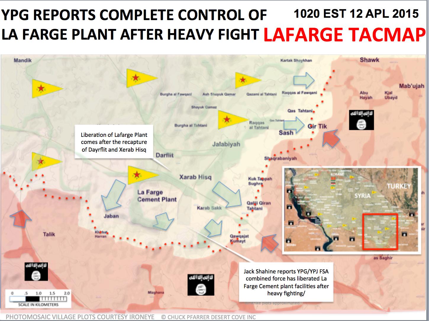
Seems that YPG is clashing with ISIS in the vicinity of the plant per SOHR (this time Arabic). --Damirgraffiti |☺What's Up?☺ 19:50, 11 April 2015 (UTC)
- But earlier the pro opposition source reported that ISIS blew up the plant after evacuating its contents and transferring them to the city of Raqqa and the blast led to the destruction of 80% of the plant.ARA News So now it just ruins and there is no reason to keep it on the map as the cement plant. And another pro opposition source also reported that ISIS destroyed this factory.here and here other data here Hanibal911 (talk) 21:03, 11 April 2015 (UTC)
- So I guess we can remove the plant symbol since they destroyed it, because apparently, someone added back that symbol into the map. Or should we not?--Damirgraffiti |☺What's Up?☺ 21:09, 11 April 2015 (UTC)
- Despite being destroyed the plant is still being contested between the two groups suggesting at least some grade of importance as a military position, so I would suggest leaving it in until the frontline moves far enough away from it for it to become irrelevant. 190.67.245.194 (talk) 07:27, 12 April 2015 (UTC)
- Some pictures of the plant have been published today, and the factory seems almost intact. https://twitter.com/jackshahine/status/587632498248671232 --8fra0 (talk) 22:19, 13 April 2015 (UTC)
That may be deceptive though. If the key internal machinery is missing, the plant is worthless. Especially without power. YPG can't supply it as satellite imagery confirms.Tgoll774 (talk) 00:02, 15 April 2015 (UTC)
Regime advances in Eastern Syria
- SOHR reporting that regime forces have advanced in Southern Qamishly countryside and captured a village from ISIS [1] If anyone knows what village they're talking about, that would be great.
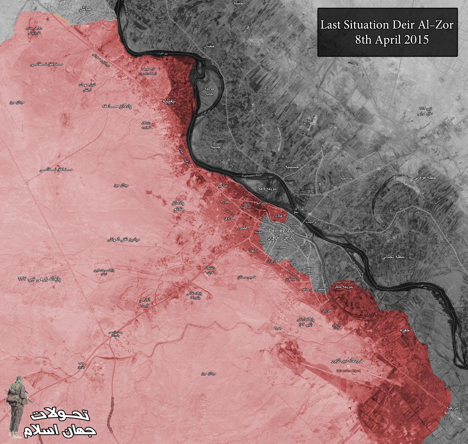
- Official Syrian Revolution Page (pro rebel) saying regime forces have captured advanced posts outside Ayyash in Deir el Zoor and have secured the riverbank there. [2]
- This means Ayyash is regime held since they launched an attack from the village to expand the security perimeter. This comes when pro-regime sources reported that SAA forces have repelled an ISIS counterattack on Ayyash. [3] ChrissCh94 (talk) 22:55, 12 April 2015 (UTC)
- ChrissCh94 Pro government source reported that Syrian troops in coordination with NDF and the Assyrian “Sootooro” milita captured village of ‘Umm Ghadeer to south from Qamishli.here Hanibal911 (talk) 08:27, 13 April 2015 (UTC)
- Alright then we have the name. Hanibal911 What do you think about Ayyash? ChrissCh94 (talk) 12:19, 13 April 2015 (UTC)
- ChrissCh94 For now I look your data about this town so I answer you shortly. Hanibal911 (talk) 12:39, 13 April 2015 (UTC)
- Alright then we have the name. Hanibal911 What do you think about Ayyash? ChrissCh94 (talk) 12:19, 13 April 2015 (UTC)
- ChrissCh94 Pro government source reported that Syrian troops in coordination with NDF and the Assyrian “Sootooro” milita captured village of ‘Umm Ghadeer to south from Qamishli.here Hanibal911 (talk) 08:27, 13 April 2015 (UTC)
- ChrissCh94 Maybe you are right that the town Ayyash for now under control by troops. But I also found a map which showed situation in this area for April 8 and this map showed that area where located TV tower now controlled by troops.here Hanibal911 (talk) 13:14, 13 April 2015 (UTC)
- ChrissCh94 here is the full report of the village of ‘Umm Ghadeer.Lindi29 (talk) 17:51, 13 April 2015 (UTC)
- Hanibal911 why is Ayyash changed to red?Lindi29 (talk) 18:51, 13 April 2015 (UTC)
- Lindi29 This was confirmed data in this discussion. But if you think that those data not confirmed that Ayash under control by army! I will revert this. Hanibal911 (talk) 19:04, 13 April 2015 (UTC)
- Hanibal911 no reliable source was provided for this town? The one that Chris provided was a pro-opp source and this case we cant use it.Lindi29 (talk) 13:51, 14 April 2015 (UTC)
- Lindi29 We can use data from the pro opposition sources for displayed success of troops. Hanibal911 (talk) 13:59, 14 April 2015 (UTC)
- Hanibal911 No we cant beacasue that against the rules,we cant use pro-side sources against another belligerent which he is fightning.Lindi29 (talk) 14:10, 14 April 2015 (UTC)
- Lindi29 But pro opposition sources not support Syrian troops they clear opposes to Syrian government but sometimes they can distort data for ISIS in clashes against troops because almost three years ISIS and rebels jointly was fighting against the Syrian army. Hanibal911 (talk) 14:38, 14 April 2015 (UTC)
- Hanibal911 they were fightning the regime when they were a small group then they broke up and now are fightning each other so we cant use this sources beacause this is not a reliable source.Lindi29 (talk) 14:50, 14 April 2015 (UTC)
- Lindi29 Well rebels fight ISIS and the regime so we can use rebel sources to display regime advances and ISIS advances. It makes perfect sense when we use one side's sources to display his opponent's gains. Even if you want to consider rebels and ISIS in the opposition, we could use their sources to display regime advances. Therefore either it was an ISIS or a rebel source, when they admit regime advances that's the ultimate confirmation. ChrissCh94 (talk) 15:00, 14 April 2015 (UTC)
- Lindi29ChrissCh94 As I said we can use pro opposition sources for displayed succes of army in clashes against ISIS and rebels(including JAN) and can use pro government sources for displayed succes of Syrian rebels(including JAN) and ISIS in clashes against Syrian troops and sometimes for displaye success of Kurds except of Hasaka province where Syrian troops and the Kurds cooperate in fights against ISIS. Also we can use pro opposition sources for displaye success of Kurds except of Aleppo and Raqqa provinces where rebels and Kurds cooperate in fights against ISIS. But we cant use the pro opposition sources for displayed success of ISIS against Syrian troops because rebels and ISIS three yers coopirated in their fight against Syrian troops so sometimes a pro opposition source also deliberately distort the data in favor of ISIS. And we can use pro ISIS sources for displayed success of rebels against ISIS and for YPG against ISIS and also in fight Syrian troops against ISIS. Also I think that not need use pro government sources for displayed success ISIS against rebels because sometimes the some sources accussed that Syrian government helps ISIS in their battle against moderate rebels. And if we stick to these rules, we will not have problems in editing a map. Hanibal911 (talk) 15:48, 14 April 2015 (UTC)
- Exactly, so Ayyash to SAA-held? What about Nab'l Murr in Latakia? It is staying green? ChrissCh94 (talk) 16:15, 14 April 2015 (UTC)
- ChrissCh94 Pro government source said that Nabi al Murr under control by rebels and we marked this village to green and pro opposition source confirmed that Ayyash controlled by Syrian troops and we marked him to red. Hanibal911 (talk) 16:28, 14 April 2015 (UTC)
- Lindi29 Well rebels fight ISIS and the regime so we can use rebel sources to display regime advances and ISIS advances. It makes perfect sense when we use one side's sources to display his opponent's gains. Even if you want to consider rebels and ISIS in the opposition, we could use their sources to display regime advances. Therefore either it was an ISIS or a rebel source, when they admit regime advances that's the ultimate confirmation. ChrissCh94 (talk) 15:00, 14 April 2015 (UTC)
- ChrissCh94,Hanibal911}} it doesn't matter how long the fighted togther,this is not acceptable,using pro-opp source to show the succes in this time for the regime??No this is not acceptable beacause they are differet faction.Lindi29 (talk) 18:46, 14 April 2015 (UTC)
- Lindi29 Wait what? So now we can't use rebel sources to display regime gains? Yeah that makes perfect sense.. let's just use rebel sources for rebel gains that's more credible *irony*. When your opponent acknowledges your gain, that's maximal credibility. Therefore when rebels admit to regime gains or ISIS gains, that means they conceded defeat thus making their statement credible. ChrissCh94 (talk) 19:48, 14 April 2015 (UTC)
- ChrissCh94 LOL you dont even know what are you talking about,I am saying how can we use pro-opp source against Isis to display regime gains,check again what we are talking about here,If we use pro-opp sources against Isis than we will use it agains the regime to.Lindi29 (talk) 17:34, 15 April 2015 (UTC)
- Lindi29 We can use antigovernment (including pro opposition source) to show success of Syrian troops but we can use antigovernment (including pro opposition source) to show success for all antigovernment groups (including ISIS) because antigovernment (including pro opposition source) throughout the conflict openly opposed against the Syrian army and their data can not be neutral to show the success of opponents the Syrian troops. Almost all pro opposition sources distort data to favor rebels and JAN in clashes against Syrian troops or ISIS. But many from this sources also distort data in clashes between Syrian troops against ISIS in favor by ISIS because Syrian government it is the main enemy of the Syrian opposition and the Syrian rebels (including Al Nusra) for nearly five years of conflict in Syria and they deliberately distort information in favor of the opponents of the government. As well as sometimes accused pro-government sources that they distort the data not only to favor by army but also sometimes in favor by opponents of the moderate rebels. It is clear that if the source constantly opposed against Syrian troops he cant be neutral or not biased when he publish data which confirm success of antigovernment forces. I also believe that we should not use the pro government sources to display the ISIS success in the fight against the rebels since many rebels accused that the Syrian government partially collaborating with ISIS in their battle against Syrian rebels. Hanibal911 (talk) 18:18, 15 April 2015 (UTC)
- Lindi29 THen why have you opposed us when we showed you a rebel source citing regime advances and takeover of Ayyash? ChrissCh94 (talk) 19:12, 15 April 2015 (UTC)
- ChrissCh94 so you agree to use pro-opp source to display Isis success? I opposed it beacause it's against the rules,I never did that,you now mention it you came out with this and look Hanibal911 what is saying i qoute "I also believe that we should not use the pro government sources to display the ISIS success in the fight against the rebels since many rebels accused that the Syrian government partially collaborating with ISIS in their battle against Syrian rebels" this means that we can use pro-opp against Isis to display regime success, but we cant use pro-gov source to display Isis success against rebels,and your reason is based on accuses not facts.End this debate here beacause you are not giving any good reason on this case.Lindi29 (talk) 18:10, 16 April 2015 (UTC)
- Lindi29 Of course I do agree on using rebel sources to display ISIS advances. Whenever a side states enemy advances, they are true. Therefore when regime sources mention rebel/ISIS advances, we believe them. When rebels state regime/ISIS advances, we believe them. When ISIS states rebels/regime advances, we believe them. That's my point. Based on that, we should keep Ayyash red. End of argument. ChrissCh94 (talk) 18:39, 16 April 2015 (UTC)
- ChrissCh94 so you are eating your own words? All that you said was i qoute "When rebels state regime/ISIS advances, we believe them. When ISIS states rebels/regime advances" thats what we do ofc but you didnt' give any pro-Isis source or reliable one to confrim,instead you used a pro-opp source for the first time to change Ayyash and you displayed success to the regime and no reliable source even confirm that. END. Lindi29 (talk) 20:15, 16 April 2015 (UTC)
- ChrissCh94 We cant use data from pro opposition sources becasue they are too biased and clear opposed to Syrian government and throughout the conflict distort the data in favor of all those who are fighting against the Syrian army. So we cant use data from the pro opposition sources to show the success for all anti-government groups because their data can not be neutral. And very often, pro opposition sources distort the data in favor of ISIS in their fight against the Syrian army because many opposition sources welcome ISIS action against the Syrian army also in addition more than three years ISIS and moderate rebels be as allies and fought together against the Syrian government and it is can also be a reason for that would exaggerate the ISIS success in the fight against the government. Since the many pro opposition sources always welcome failures of Syrian troops in the fight against the rebels but also against ISIS. The same sources who openly oppose the Syrian government and has an aversion to the Syrian army, their data can not be neutral in the struggle of the Syrian army against the rebels, or ISIS. And in this issue can not be compromises or exceptions. Just as I said earlier will be better not to use the pro government sources for display the success by ISIS in their fight against moderate rebels because many times Syrian opposition accused the Syrian government in supporting ISIS against moderate rebels and some from Western countries also claims that the government is partialy working with ISIS and that the Syrian Air Force sometimes bombed rebel positions when ISIS advance against moderate rebels as well as the rebels accuse Syrian troops that they helped ISIS in their attack on the rebel position in the Yarmouk camp. Hanibal911 (talk) 20:59, 16 April 2015 (UTC)
South West Aleppo countryside
From http://www.almasdarnews.com/article/hell-reigns-supreme-over-hell-syrian-army-makes-substantial-gains-in-the-south/ the poultry taken by SAA. Al-Wadiha seem contested. Objections? 87.9.149.62 (talk) 18:59, 13 April 2015 (UTC)
I strongly object to chicken farms being added to map just because there is fighting there .86.178.97.43 (talk) 15:32, 15 April 2015 (UTC)
Updates in Kobane
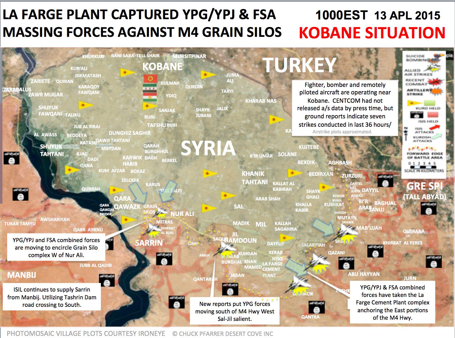
Based on Chuck Pfarrer map1 & map2, Shash, Khan mamid, Jaban, Sal, Hamadun(&jayl), Qalat hadid and Nur Ali are with YPG. Mitras is with ISIS. Ricardomoha (talk) 11:36, 14 April 2015 (UTC)
- We cant use pro Kurdish sources for displayed success of Kurds. Hanibal911 (talk) 15:49, 14 April 2015 (UTC)
By this logic all western sources are pro-kurds, also SOHR can't be used as well.. Then only ISIS sources or Regime sources are accepted which makes no sense to me. Ricardomoha (talk) 18:59, 14 April 2015 (UTC)
https://pbs.twimg.com/media/CC5zFsyVIAAtf33.jpg:large Latest map. Basically status quo ante plus from last year.Tgoll774 (talk) 01:40, 19 April 2015 (UTC)
Latakia
Have the rebel forces advanced in Latakia ? many more villages added and some taken from the SAA ? I have not read of any resent advance ,can someone kindly explain the situation .86.178.97.43 (talk) 18:38, 14 April 2015 (UTC)
SAA is in or near Rabia ... If u change towns, only with Sources please. To much anti-governments editors
WTF is that for nonsense? He/She who changed all those towns to green in Latakia better change it back to red or post some decent sources here.SyAAF (talk) 21:14, 14 April 2015 (UTC)
The area has been changed several times due to different reports. Pro-opposition maps are showing always the same, and editors are changing this region according to them when a pro-gov or neutral source poops ops with a statement which might confirm that. And SOHR and some other sources were reporting that rebels atacked gov positions with GRAD rockets here and there near Latakia city, which might be logical because they are this close, and the range is limited. DuckZz (talk) 08:34, 15 April 2015 (UTC)
No Reliable Source is backing those changes actually? Are you saying that?Mr.User200 (talk) 13:17, 15 April 2015 (UTC)
The editor who made these changes needs to explain why they were changed or they should be reverted as its not one village but a big area .86.178.97.43 (talk) 13:44, 15 April 2015 (UTC)
I have no idea, because i did not change it. But the user posted a pro-government source and a pro-opposition map which both match up, so i guess it's ok as we often use pro-opposition sources combined with government maps to make edits in favor for the government. DuckZz (talk) 10:25, 16 April 2015 (UTC)
Why aren't these changes changed back to the original? Sources are lacking, which means the they need to be changed back. MesmerMe (talk) 20:21, 19 April 2015 (UTC)
Semi-protected edit request on 15 April 2015
This edit request to Module:Syrian Civil War detailed map has been answered. Set the |answered= or |ans= parameter to no to reactivate your request. |
change
{ lat = "34.015", long = "38.098", mark = "80x80-lime-black-anim.gif", marksize = "6", label = "Al Ulayyaniyah", link = "Al Ulayyaniyah", label_size = "0", position = "top" },
to
{ lat = "34.015", long = "38.098", mark = "Location dot lime.svg", marksize = "6", label = "Al Ulayyaniyah", link = "Al Ulayyaniyah", label_size = "0", position = "top" },
source:
http://www.understandingwar.org/backgrounder/syria-situation-report-april-7-14-2015
2601:0:B200:F7D9:1562:E9FB:1354:9CA9 (talk) 02:22, 15 April 2015 (UTC)
- This data from the pro opposition source so that need confirmations from a neutral source. This source called Syrian troops as the regime forces and this clear mean that this pro opposition source and we cant use him for displayed success of rebels. Hanibal911 (talk) 12:01, 15 April 2015 (UTC)
- What are you talking about? The Institute for the Study of War is not a pro opposition source. It is always been used as a reliable source, especially to show both Isis advances and retreats.
- It this clearly antigovernment source which used data from pro opposition sources and clear opposes to Syrian government and called him troops as regime forces or Assad troops. Hanibal911 (talk) 10:38, 16 April 2015 (UTC)
- What are you talking about? The Institute for the Study of War is not a pro opposition source. It is always been used as a reliable source, especially to show both Isis advances and retreats.
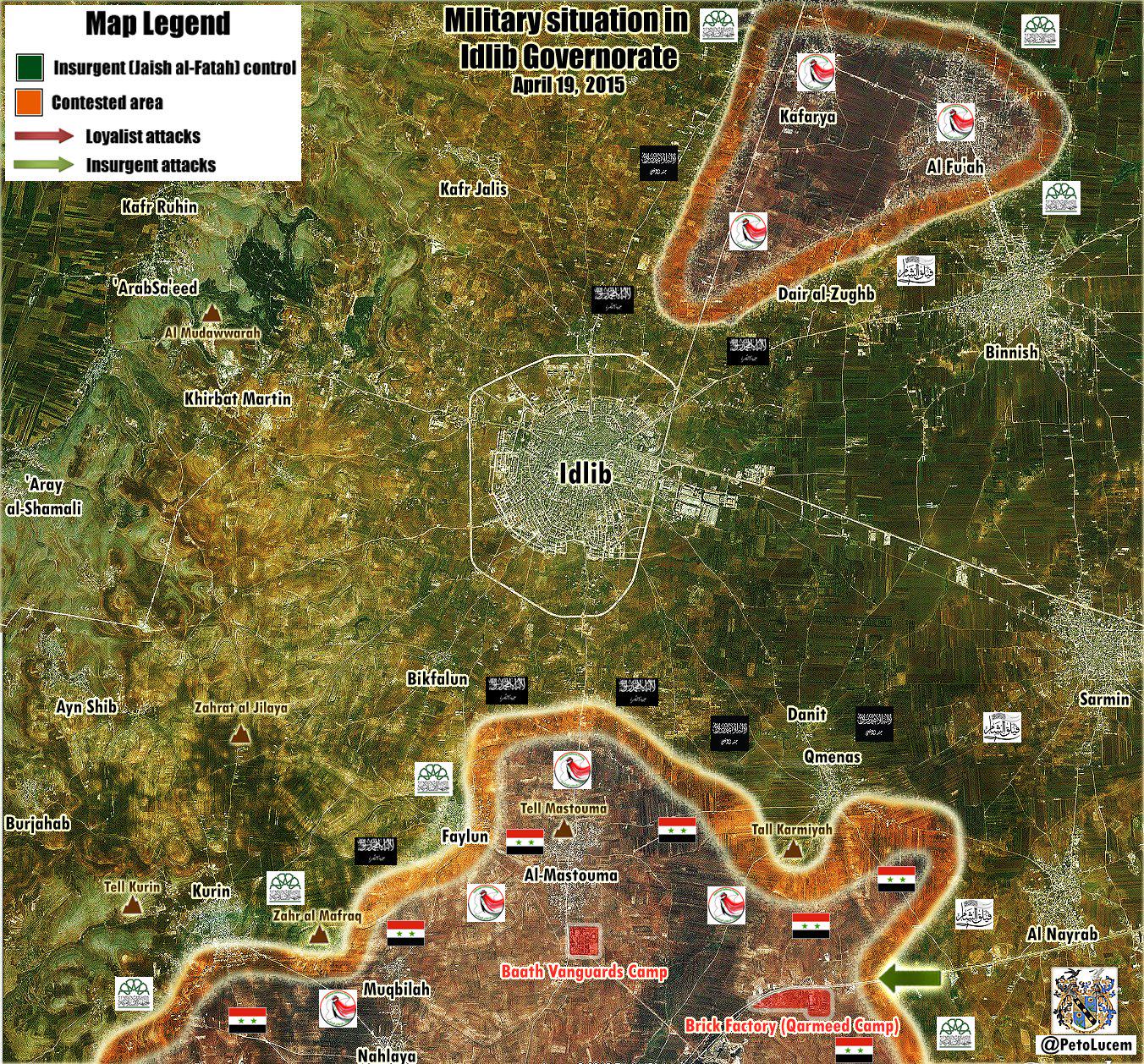
Idlib
There are many mentions that SAA controlled Najd Kafr and Nahlaya. E.g. http://www.almasdarnews.com/article/syrian-army-makes-fresh-gains-in-idlib-kafr-najd-under-fire-control/ from yesterday evening reports Najd Kafr almost taken. Teh same source states that Qameenas is contested. On the map Najd Kafr is already red, while Nahlaya is contested and Qameenas green. Any neutral source not on twitter reporting this changes?Paolowalter (talk) 12:03, 15 April 2015 (UTC)
- SOHR also confirmed that Syrian troops recatured village of Kafr Najd.SOHR Hanibal911 (talk) 13:32, 15 April 2015 (UTC)
- 1) They are both considered controlled by the gov at the moment anyway. 2) They may have already retreated https://twitter.com/arabthomness/status/588327180830171136 At the very least Kafr Najd should be changed to contested
- SOHR confirmed that the village of Kafr Najd under control of Syrian troops so we cant mark this village as contested on based data from biased pro opposition source. Hanibal911 (talk) 13:52, 15 April 2015 (UTC)
- Pro opposition source said that the Syrian troops gained control over the villages of Kafer Najed and Nahelya in Idlib southern countryside after severe clashes with Islamic battalions.Document.Sy Hanibal911 (talk) 14:06, 15 April 2015 (UTC)
- 1) They are both considered controlled by the gov at the moment anyway. 2) They may have already retreated https://twitter.com/arabthomness/status/588327180830171136 At the very least Kafr Najd should be changed to contested
Acc. pro opposition source: Syrian Army imposes firearms-control over al-Muqblah town in Idlib countryside, after restoring Kafer Najed and Nahlaia today morning. Documents.sy 83.30.58.17 (talk) 18:33, 15 April 2015 (UTC)
- This same source said: As clashes continue with fighters of al-Fateh Army around Feeloun and Qoureen villages in the southern countryside. Faylun - besieged on the south and east? 83.30.58.17 (talk) 18:38, 15 April 2015 (UTC)
- Acc pro gov source ivansidorenko1 and pro rebel TheQalamon about Kurin - is also under control of SAA / fighting in city 83.30.58.17 (talk) 19:35, 15 April 2015 (UTC)
- Pro opposition source also reported that Syrian troops also captured the town of al-Muqblah and that clashes continue with fighters of al-Fateh Army around Feeloun and Qoureen in the southern countryside.Documents.sy Hanibal911 (talk) 20:44, 15 April 2015 (UTC)
- Another one pro opposition source reported that hevy clashes in the village of Kurin and Syrian troops are trying to take over Kurin.Syrian Rebellion Observatory Hanibal911 (talk) 09:09, 16 April 2015 (UTC)
- Another source confirmed that Syrian troops captured three villages of Kafr Najd, Nahlaya and Muqbileh.World Bulletin Hanibal911 (talk) 19:23, 17 April 2015 (UTC)
- Another one pro opposition source reported that hevy clashes in the village of Kurin and Syrian troops are trying to take over Kurin.Syrian Rebellion Observatory Hanibal911 (talk) 09:09, 16 April 2015 (UTC)
- Pro opposition source also reported that Syrian troops also captured the town of al-Muqblah and that clashes continue with fighters of al-Fateh Army around Feeloun and Qoureen in the southern countryside.Documents.sy Hanibal911 (talk) 20:44, 15 April 2015 (UTC)
- Acc pro gov source ivansidorenko1 and pro rebel TheQalamon about Kurin - is also under control of SAA / fighting in city 83.30.58.17 (talk) 19:35, 15 April 2015 (UTC)
- Pro opposition source reported that rebels have withdrawn from the town Kurin because of lack of support from main HQ.Latif MfitaL Hanibal911 (talk) 07:10, 21 April 2015 (UTC)
Khanasser
http://www.almasdarnews.com/article/main-government-supply-line-to-aleppo-cleared-syrian-army-captures-al-rashadiyah/ states that Al-Rashadiyah close to the Khanasser highway is taken by SAA. Where is this village?Paolowalter (talk) 12:10, 15 April 2015 (UTC)
- Paolowalter Here village of Al-Rashadiyah here But need confirmation this data from neutral source becasue Al Masdar it is pro government source and we cant use him for displayed success of Syrian troops. Hanibal911 (talk) 12:30, 15 April 2015 (UTC)
- SOHR reported about clashes in Rashadiyah in Khanasser area near the southern countryside of Aleppo.SOHR Hanibal911 (talk) 13:35, 15 April 2015 (UTC)
https://en.wikipedia.org/w/index.php?title=Talk:Cities_and_towns_during_the_Syrian_Civil_War&action=edit§ion=12 Can someone confirm this and check on FSA claims to have also cut SAA supply routes to Aleppo. A lot of twitter posts about Rebels and IS advances south of Aleppo and cutting the road overnight. Tgoll774 (talk) 13:53, 19 April 2015 (UTC)
- Tgoll774 There conversely army captured some area near the road and are repelled several attacks of ISIS on this road. Hanibal911 (talk) 14:57, 19 April 2015 (UTC)
So basically a propaganda war, like with Baiji and others. But from the video its clear some level of combat is going on in the area from FSA and IS. FSA feeds claim IS hold Khanasser, SAA denies, FSA ah screw it. I say lock all edits for a week till we get better info, because it appears we hit a new mobile phase where settlements change hands every day. Tgoll774 (talk) 15:45, 19 April 2015 (UTC)
ISIS withdrawn from Yarmouk Camp
ISIS fighters have largely withdrawn from a Palestinian refugee camp on the outskirts of Damascus after expelling their main rival. The pull-out ISIS from Yarmouk leaves Al Nusra as the main group inside the camp. ISIS had returned to their stronghold in neighboring Hajar al Aswad, from where they had launched their attack. The Palestine Liberation Organization envoy to Damascus said that Nusra was now the main group in the camp. They and Nusra are one. They are changing of positions.The Daily Star Hanibal911 (talk) 14:48, 15 April 2015 (UTC)
- But SOHR reported that ISIS still controlled 80% of the Yarmouk camp the remaining 20% controlled by Islamic groups and Palestinian factions loyal to the Syrian government and clashes still continuing.SOHR Hanibal911 (talk) 18:58, 16 April 2015 (UTC)
Rebels reject cooperation with Al Nusra on Southern front
Essam al-Rayes' a spokesman of Southern front said that rebels in southern Syria will not cooperate with Al-Nusra after tensions between local rebel groups and Nusra in border crossing between Syria and Jordan. Essam al-Rayes said that "We reject all forms of cooperation with al Nusra and we dont want Syria to become a base for jihad, or the expansion of the Islamic State (ISIS),"The Daily Star So that as I said earlier the situation with the Al Nusra is becoming more similar to the situation with the ISIS which also previously cooperated with moderate rebels against Syrian troops. Hanibal911 (talk) 15:01, 15 April 2015 (UTC)
SAA's Al-Husayniyah Enclave
The SAA's Al-Husayniyah Enclave has been destroyed by ISIL therefore it doesnt exist anymore confirm my Mark Monmonier
https://twitter.com/MarkMonmonier/status/588052895481864192
https://twitter.com/MarkMonmonier/status/588133817891876864
Who the hell is mark mononier (isil fanboy ) and how do you post on here without any name or number?86.178.97.43 (talk) 15:53, 15 April 2015 (UTC)
Haibal911 2 tweets and a map from 1 source and that's enough evidence is it? this map does not belong to you .86.178.97.43 (talk) 21:03, 15 April 2015 (UTC)
Hanibal, this edit is against the rules. While your source may not oppose the SAA directly, it is still not authoritative enough [we cannot tell how reliable its info is]. Think about it, if they really did "destroy" the enclave, why are the pro-ISIS fanatics not talking about it? We need more sources than just one twitter source to change an entire area from red to black. XJ-0461 v2 (talk) 21:42, 15 April 2015 (UTC)
I agree. There is no indication that this statetements from MakrMonmonier are reliable. Let's just ignore them. Paolowalter (talk)
- PaolowalterXJ-0461 v2 Firstly this source is pro Kurdish and because Kurds and Syrian troops jointly fights against ISIS we can use data from the pro Kurdish sources for displayed success ISIS. And secondly here another source which also showed that now this area under control by ISIS and that the positions of Syrian troops for now located east from this area near of the city of Hasakah.here Hanibal911 (talk) 07:15, 16 April 2015 (UTC)
Just another map .this is not like you to make quick changes without many sources .149.254.56.66 (talk) 14:03, 16 April 2015 (UTC)
Qalamoun military sites
Why is there a rebel held site near Flita and a regime held Tall Hankal? There are dozens of those sites littered in the region so we can't just add 2. I suggest either adding all of the Qalamoun military/observation posts (IMPOSSIBLE) or just remove those 2 insignificant sites. There are full army brigades that we haven't added yet; why should we add a small post manned by 10-15 men? ChrissCh94 (talk) 20:39, 15 April 2015 (UTC)
- ChrissCh94 Pro opposition source reported that Syrian troops captured Tall HankalDocuments.Sy and I added it. Also later the reliable source said that rebels entered to Syria in area of Qalamoun from Lebanon and after clashes against Hezbollah they captured hill al-Mesh with overlooking on Flita.The Daily Star and I added this hill at map. Hanibal911 (talk) 21:17, 15 April 2015 (UTC)
I'd tend to avoid cluttering the map with small locations of limited (if any) strategic value. SAA and Hezbollah are taking position around Zabadani every day, it does not mean we have to mark all of them.Paolowalter (talk) 07:05, 16 April 2015 (UTC)
- I perfectly agree with Paolowalter and many of these sites change hands regulary, they're just small posts not important bases/checkpoints. ChrissCh94 (talk) 07:47, 16 April 2015 (UTC)
- Paolowalter ChrissCh94 Near the town of Zabadani, I added only strategically important hills from which the army shelled rebel positions in the city. Also in the area of town Flitah I added two hills for which there were hevy clashes because probably this is strategically important hills. Hanibal911 (talk) 09:06, 16 April 2015 (UTC)
- I perfectly agree with Paolowalter and many of these sites change hands regulary, they're just small posts not important bases/checkpoints. ChrissCh94 (talk) 07:47, 16 April 2015 (UTC)
Add more villages in south-east Kobane canton?
Is it possible to add some more villages in the south-east of Kobane canton and north-west of Raqqah province? It would show the actual frontline more accurately, because there is "hole" on the map now.
I would suggest to use this map: https://twitter.com/MarkMonmonier/status/587511795180503040 It matches with the wikipedia map so far, although the villages spelling is different. So could someone please add JALABIYAH as held by YPG and SAB JIFAR as held by IS.
We will add new villages when there are reports about clashes inside them or that YPG/IS captured it. DuckZz (talk) 09:51, 17 April 2015 (UTC)
Marks moving 1 pixel down
About 90% of the location dots and other marks appear to have moved 1 pixel down. This might not seem important, but it makes updating the .png map a lot slower, because I rely on finding the difference between screenshots to make the maps, and there are about 150 marks to go through on this map, plus those on the Iraqi map. I was wondering if anyone knew what the cause might be. Banak (talk) 17:02, 17 April 2015 (UTC)
I don't know exactly, but I am one of the main editors of the "War in Donbass Detailed Map", and I remember making an edit to the page outside of the map, and that moved all of the dots down very much.
http://en.wikipedia.org/wiki/Template:Donbass_War_detailed_map
You can look at the edit history of both to find a similarity. I hope this helps. 2601:0:B200:F7D9:D9DE:96EB:1551:6659 (talk) 22:50, 17 April 2015 (UTC)
Nab Al-Murr
SAA captured Nab Al-Murr 1 year ago during the kesab counteroffensive. http://www.al-monitor.com/pulse/security/2014/03/syria-kasab-opposition-army-battles.html and still saa control the town , please fix it92.44.119.74 (talk) 18:26, 17 April 2015 (UTC)
read please , it clearly says saa recaptured the town http://en.wikipedia.org/wiki/2014_Latakia_offensive
Tal Barak updates
According to this Map, which is from a pro-kurd source, Kakah said is with ISIS, also update the hasakah map with SAA advance. Ricardomoha (talk) 19:12, 17 April 2015 (UTC)
- Why am I getting this feeling that this and many others are just WP:CIRC? EllsworthSK (talk) 10:28, 18 April 2015 (UTC)
- Give me a proof not feelings. Ricardomoha (talk) 18:26, 18 April 2015 (UTC)
- Are we using maps? I thought we were trying to abandon using them unless they provided sources to avoid WP:CIRC? Banak (talk) 20:44, 18 April 2015 (UTC)
- That doesn't make sense, because his original map had Kaka said under SAA control on 4/4/2015 and now it's under ISIS control on 18/5/2015, we can take his word because he's a pro-kurdish source. Simple as that. If your point is that this map was maybe taken from old Wiki maps his original map denies that. Ricardomoha (talk) 13:09, 19 April 2015 (UTC)
Use of Pro-gov sources to change rebel towns to Nusra
I have noticed that pro-government source PetoLucem https://twitter.com/petolucem often uses Al-Nusra flags in rebel-held territories to imply his viewers that Al-Nusra is in control of those towns.
https://pbs.twimg.com/media/CC-RSZTVAAEzuEN.jpg:large
https://pbs.twimg.com/media/CCyrc8nWEAATHdm.jpg:large
I think that we should not use this pro-govermnet source to edit rebel towns to Al-Nusra control, as this is an attempt by PetoLucem to brand most of the rebels as extreme jihadists who are part of al-Qaeda, to make people turn to his side. Secondly, him putting black Nusra flags does not necessarily mean that towns under these flags are under direct al-Nusra control; it simply is showing that al-Nusra forces are present on those front lines fighting. I think that if we keep doing this, eventually all of the green towns will be turned to grey simply because petolucem has black flags on his map. I also do not think he qualifies as a reliable source to prove al-Nusra control. Let me also say that I am not pro-rebel, pro-government, or pro-Nusra. I just think these towns should not be turned to grey because PetoLucem says they should. 2601:0:B200:F7D9:1547:CFD2:5C0E:E250 (talk) 19:20, 19 April 2015 (UTC)
- The map you show is of Idlib. Al-Nusra has a dominant presence there, that is why all the flags are black. This is confirmed by multiple sources. If you look here at this Daraa map: https://twitter.com/PetoLucem/status/571759910653992960 you will see that there are in fact FSA flags plus nusra flags on it. I do not think he deliberately attempts to brand the rebels as Al-Qaeda. Problem is, rebels cooperate frequently with them, making it hard to determine who controls what. Still, I agree that we should use neutral sources for such changes. XJ-0461 v2 (talk) 19:41, 19 April 2015 (UTC)
Petolucem said on twitter more than once that he belives Al Nusra controls 80% of rebel towns, which is crazy but he knows what kind of news his followers want to see. He is not an extreme pro-regime reporter like Leith Fadel for example but he understands that 80% of his readers are pro-government oriented, and they want that "Syrian army vs Al Qaeda" scenario, that's the reason they hate other rebel groups, mostly because the world needs no reason to hate ISIS or Al Nusra, but every other group seems to have some kind of a "OK" reputation. DuckZz (talk) 20:18, 19 April 2015 (UTC)
- DuckZz If you believe that I was wrong when using these maps when would I noted the villages which is under the control of Al Nusra I revert those my actions or I can mark these villages as under jointly control rebels/Al Nusra. Hanibal911 (talk) 20:26, 19 April 2015 (UTC)
Hanibal911 I can't revert it, because of, do it yourself. DuckZz (talk) 20:43, 19 April 2015 (UTC)
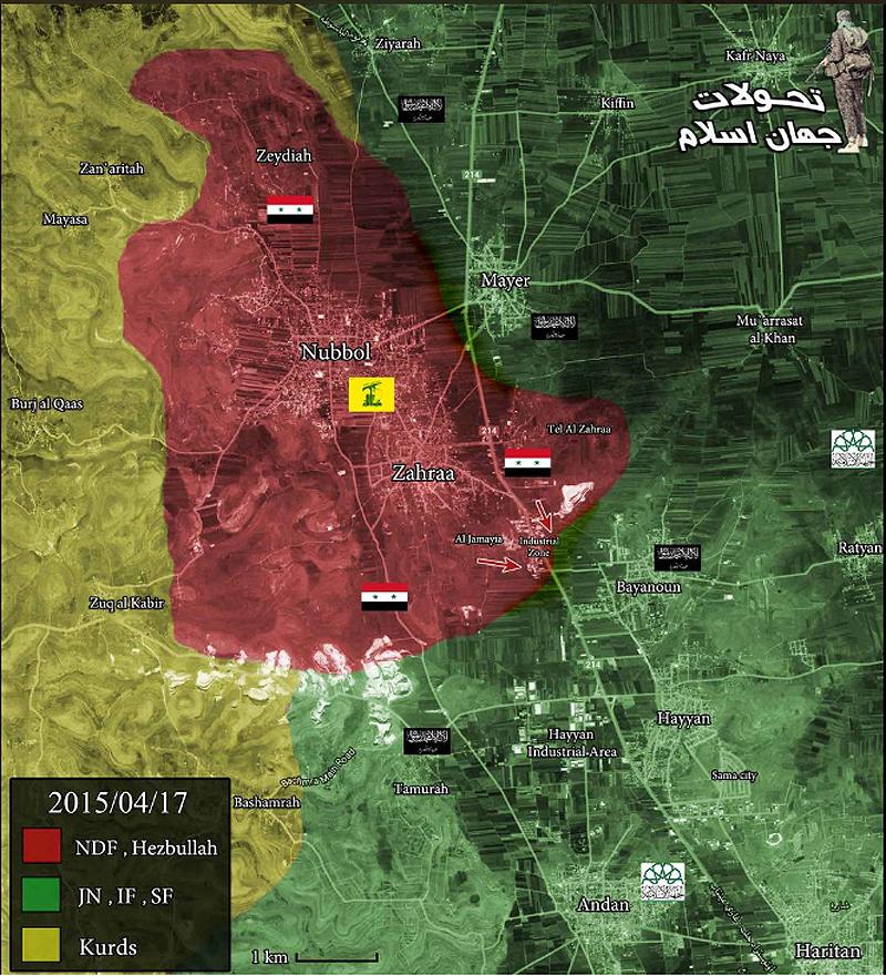
- DuckZz I again mark villages of Mayer and Bayanoon as under control by rebels and Rityan as under jointly control as it was earlier but I mark as under jointly control the village of Tannurah which is I add according to data from pro government source and Ziyarah which is I edit from under Kurdish control to under jointly control FSA/JAN. So that the villages of Ziyarah and Tannurah will be marked as under jointly control before we not find to more data. Hanibal911 (talk) 20:57, 19 April 2015 (UTC)
You can't use government sources for those changes, revert it, and use kurdish sources if you think something may need to be changed, but everything else should be reverted. DuckZz (talk) 21:03, 19 April 2015 (UTC)
- DuckZz You can point me that I need fix and and I will do it because just so it will be easier for me. Hanibal911 (talk) 08:08, 20 April 2015 (UTC)
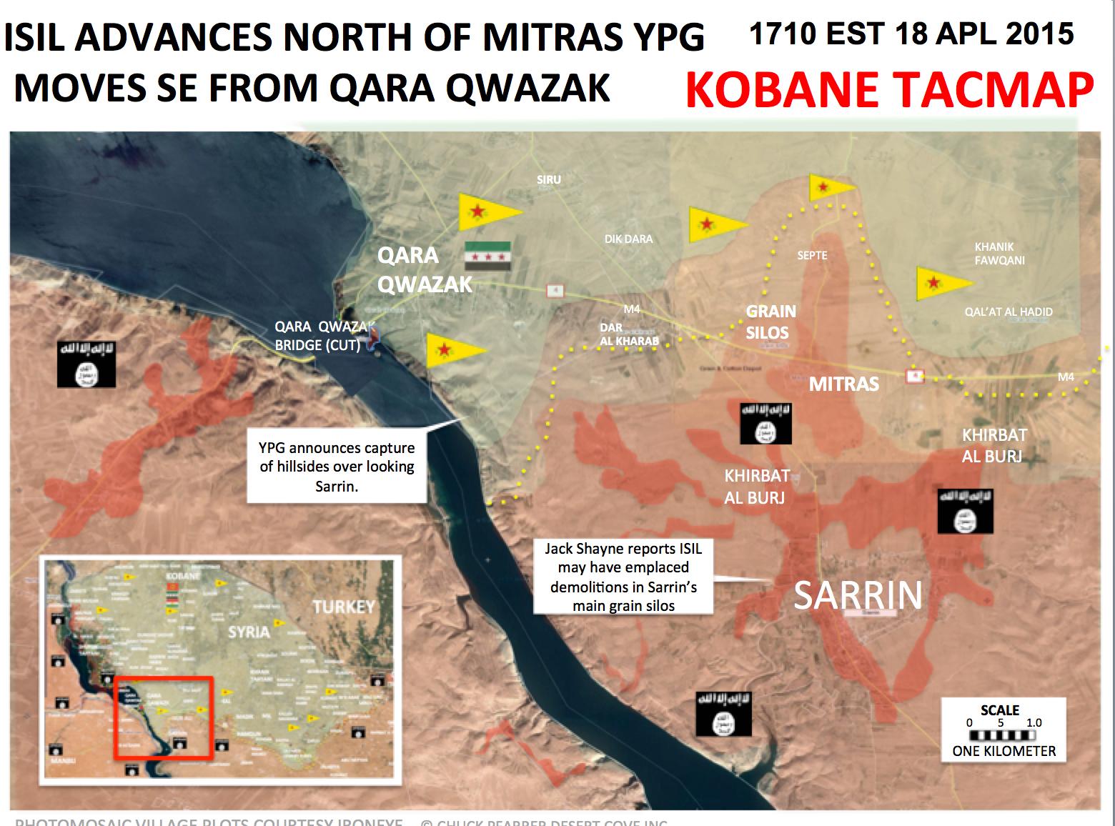
YPG east of Sarrin
YPG has taken control over several villages and hills east of Sarrin, among them are known several villages whose names begin with Qirat, and a village which in Kurdish is called Serekaniye. http://www.4.hathalyoum.net/580799-%D8%A7%D9%84%D9%82%D9%88%D8%A7%D8%AA-%D8%A7%D9%84%D9%83%D8%B1%D8%AF%D9%8A%D8%A9-%D8%AA%D8%B3%D9%8A%D8%B7%D8%B1-%D8%B9%D9%84%D9%89-4-%D9%82%D8%B1%D9%89-%D9%88%D8%AA%D9%84%D8%A7%D9%84-%D8%A7%D8%B3%D8%AA%D8%B1%D8%A7%D8%AA%D9%8A%D8%AC%D9%8A%D8%A9-%D8%A8%D9%85%D8%AD%D9%8A%D8%B7.html
http://www.syrianewsapp.com/1/Article/2114/83262104#.VTQTAiGqqko
http://www.alahednews.com.lb/fastnews/267296/%D8%A7%D9%84%D9%88%D8%AD%D8%AF%D8%A7%D8%AA-%D8%A7%D9%84%D9%83%D8%B1%D8%AF%D9%8A%D8%A9-%D8%AA%D8%B3%D9%8A%D8%B7%D8%B1-%D8%B9%D9%84%D9%89-%D8%B9%D8%AF%D8%A9-%D9%82%D8%B1%D9%89-%D9%81%D9%8A-%D8%A7%D9%84%D8%AC%D8%A8%D9%87%D8%A9-%D8%A7%D9%84%D8%AC%D9%86%D9%88%D8%A8%D9%8A%D8%A9-%D8%A7%D9%84%D8%B4%D8%B1%D9%82%D9%8A%D8%A9-%D9%84%D9%83%D9%88%D8%A8%D8%A7%D9%86%D9%8A#.VTQTECGqqko Roboskiye (talk) 20:54, 19 April 2015 (UTC)
This source says Qirat and Mitras villages were captured. But we should wait for SOHR or other twitter sources DuckZz (talk) 21:28, 19 April 2015 (UTC)
Nabe' El Murr - Latakia
Here is my point of view on how Nabe' El Murr is regime held:
- 1- Nabe'El Murr overlooks Kessab thus allowing fire control over the village and the crossing.
- 2- Rebel sources mentioning regime advances FROM Nabe' EL Murr towards Jabal Zahya where the SAA has captured Tall Snan and Tallat Wasat. [4] [5] [6] This advance was not possible if the regime did not control Nabe' EL Murr.
- 3- Rebel sources saying they shelled regime positions in Nabe' EL Murr [7] [8] [9]
- 4- Regime forces do control Mount AL Nisr, and this directly and easily overlooks the whole area and easily controls Nabe' El Murr. If the rebels were inside the village they are sitting ducks.
- The only thing contradicting me is the Al-Masdar article that said Nabe' EL Murr is rebel-held. Your thoughts? ChrissCh94 (talk) 21:31, 19 April 2015 (UTC)
I belive we should change it to contested. Pro-opposition sources said that they are trying to advance towards Kessab, and this means Nabe El Murr is not rebel held but contested as Al Masdar has noted. DuckZz (talk) 21:39, 19 April 2015 (UTC)
- ChrissCh94DuckZz Pro opposition sources reported that they not control Nabe' El Murr and we need mark him as under control by Syrian troops. Source Al Masdar make many mistakes he said that rebels start offensive near Kessab but pro opposition source Cédric Labrousse said that this was just a small campaign near Kessab and Tower 45 created in fact with one goal : divide the regime forces advancing at dlib southern coutryside.Syrian Rebellion ObservatorySyrian Rebellion Observatory So that it was just a small attack for that would distract the Syrian army from their offensive on the city of Idlib. SOHR also just said that about clashes between regime Syrian troops and their allied against rebels and the Islamic militant from another party, near the Observatory 45.SOHR Also another the pro opposition source reported that only Al Masdar reported that the rebel attacked Syrian troops in the area the border crossing. And that rebel channels have not released news about the attack.EA WorldView So maybe the Chief editor of Al Masdar was wrong when he said that Nabi al Murr under control by rebels. Also another pro government source showed that Nabi al Murr under control by Syrian troops.here So we have data from the pro opposition sources from SOHR and from pro government source that Nabi al Murr under control by Syrian troops but rebels located to east from him. So we need marked him as under control by Syrian troops. But we marked him as under rebels control only on base the data from pro opposition source which is dated on the end of December 2014 and on the one report from Al Masdar. But many other sources said that he under control by troops and this wrong because data from pro opposition source too outdated and pro government source maybe was wrong because his data not support other pro government sources. And pro opposition source deSyracuse also showed that this town under control by troops.here but rebel positions located to east from him. Hanibal911 (talk) 07:27, 20 April 2015 (UTC)
Some more info from http://www.almasdarnews.com/article/jabhat-al-nusra-attack-on-kassab-repelled/. Nabe' El Murr is back under SAA control, previously was contested. I'd say re dwith a green hal ring on the right.Paolowalter (talk) 07:03, 20 April 2015 (UTC)
Turning Nabe' El Murr contested is unreasonable. It used to be red (see above) it was turned green on the basis of an Al Masdar report and Al Masdar shortly after remarked that the town is back to SAA control. Beside Al Masadr being reliable in general, Al Masdar is not announcing a SAA advance but a short lived rebel advance, followed by restoration of the previous status quo. Therefore Nabe' El Murr back to red as it used to be.Paolowalter (talk) 11:48, 21 April 2015 (UTC)
Rebel presence in the mountains near Bureij and Hisyah
I think we should add a rural presence to signal the presence of rebels in the mountain range. A very interesting article by the neutral Al Safir newspaper (frequently quoted by AL Monitor due to its neutrality) that was shared by the pro-gov facebook page shows what rebels control in AL Qalamoun [10]: 3000 rebels controlling 1000km2 of territory including: Tal'at Moussa (aka Moussa MT) - Barouh Mount etc. (dozens of mounts and areas) but most importantly, they control the mountains near Bureij and Jawsiah and Qara. I already said that we cannot add all those mountain peaks but we could resume that by adding rebel rural presence in the space between Qara and Jawsiah crossing. Oh and I suggest removing those 2 mounts near Flita, there are dozens of those and they clutter the map. ChrissCh94 (talk) 21:52, 19 April 2015 (UTC)
- ChrissCh94
 Done I add mark which showed rebels presence to west from Qara and Bureij between the town of Qara and Jawsiah. Hanibal911 (talk) 06:53, 20 April 2015 (UTC)
Mseikeh & NE Daraa
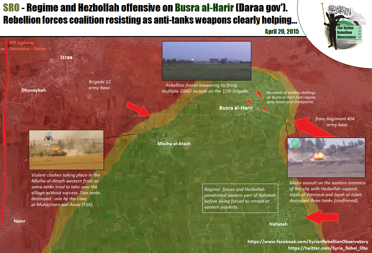
It seems that the SAA 5th has launched an attack on NE Daraa and has captured 5 villages. Mseikeh is the only one that is in the map and should be changed to Government held. Sources are pro-opp and pro-gov. [1], [2], [3], [4], [5], [6], [7]. MesmerMe (talk) 10:56, 20 April 2015 (UTC)
According to document sy. SAA captured Miskya al-Sharqia and al-Gharbiya, al-Khwabe, Ishnan, al-Dallafa https://www.facebook.com/documents.sy/posts/929032690492821 Miskiyah location: http://wikimapia.org/#lang=tr&lat=32.911874&lon=36.341915&z=14&m=bHwinsp (talk) 11:26, 20 April 2015 (UTC)
- Biased a pro opposition source also reported that the Regime troops launched new offensive on the town of Busra al-Harir.Archicivilians Hanibal911 (talk) 11:32, 20 April 2015 (UTC)
- I didn't mention the other villages captured since I had a very hard time finding any of them. Anybody had any luck? MesmerMe (talk) 11:41, 20 April 2015 (UTC)
other villages probably here: http://wikimapia.org/#lang=tr&lat=32.871586&lon=36.331959&z=13&m=b&gz=0;363000297;328518313;581073;281162;350189;305669;0;89404;263500;0;538158;78590;568199;271070Hwinsp (talk) 11:45, 20 April 2015 (UTC)
- Would it be smart to include one of the village to indicate that Busra al-Harir is surrounded (http://wikimapia.org/#lang=en&lat=32.877857&lon=36.338654&z=12&m=b&show=/31775463/Village)? To include all of them isn't necessary since they're likely very small. MesmerMe (talk) 11:55, 20 April 2015 (UTC)
- Pro government source reported that Syrian troops captured villages East Maseekat, West Maseekat, Rassum Al-Khawaabi, Ishnaan, and Al-Dalasat in northeast Dara.Al Masdar Hanibal911 (talk) 12:18, 20 April 2015 (UTC)
Pro Rebel source[8] says that the SAA is attacking Nahtah from the East. There should be a red circle on the right side of the town. MesmerMe (talk) 13:45, 20 April 2015 (UTC)
- SOHR also confirmed that the Syrian troops cut all supply line of rebels between the town of Busra al Harir and other rebel positions in the Lajat after captured villages near Busra al Harir.SOHR Hanibal911 (talk) 14:07, 20 April 2015 (UTC)
- Maybe we need add red semicircles near villages which is under control by rebels in Lajat becasue the pro opposition source and SOHR clear said that Syrian troops cut all rebel supply lines in Lajat and that now rebels in this area under siege becasue they in blockaded after all their supply lines with another territory under control by rebels.SOHRSyrian Rebellion ObservatorySyrian Rebellion Observatory For now we have situation is the same as well as to the north of the city of Homs where the some towns and villages are under the control of the rebels but cut off from supply lines. Hanibal911 (talk) 14:29, 20 April 2015 (UTC)
- I agree. These towns are currently fully surrounded much in the same nature as Northern Homs. MesmerMe (talk) 14:37, 20 April 2015 (UTC)
- These two to almost identical situations. Also so we have noted previously some villages which is was under the control of the army in the Idlib province near the town Maarat Numan and military bases (Wadi Daif and Hamidiyah) before they were captured. Those villages were also cut off from the supply lines. Hanibal911 (talk) 15:16, 20 April 2015 (UTC)
- Also my actions confirmed the pro opposition source.Syrian Rebellion Observatory He also reported that the Regime take over the supply lines and villages between Lajat area and Busra al Harir. Hanibal911 (talk) 17:40, 20 April 2015 (UTC)
- These two to almost identical situations. Also so we have noted previously some villages which is was under the control of the army in the Idlib province near the town Maarat Numan and military bases (Wadi Daif and Hamidiyah) before they were captured. Those villages were also cut off from the supply lines. Hanibal911 (talk) 15:16, 20 April 2015 (UTC)
- I agree. These towns are currently fully surrounded much in the same nature as Northern Homs. MesmerMe (talk) 14:37, 20 April 2015 (UTC)
- Maybe we need add red semicircles near villages which is under control by rebels in Lajat becasue the pro opposition source and SOHR clear said that Syrian troops cut all rebel supply lines in Lajat and that now rebels in this area under siege becasue they in blockaded after all their supply lines with another territory under control by rebels.SOHRSyrian Rebellion ObservatorySyrian Rebellion Observatory For now we have situation is the same as well as to the north of the city of Homs where the some towns and villages are under the control of the rebels but cut off from supply lines. Hanibal911 (talk) 14:29, 20 April 2015 (UTC)
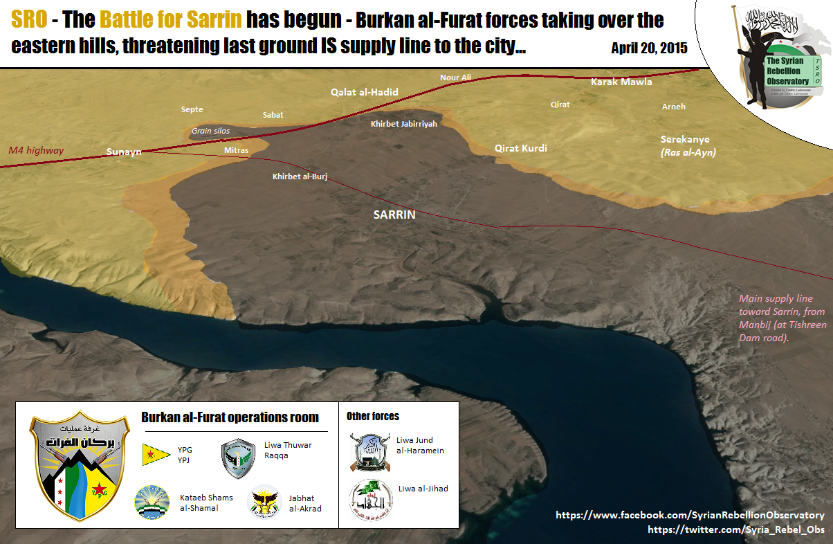
YPG/rebels offensive against ISIS in Sarrin
Pro opposition and pro Kurdish source reported that Kurdish troops(YPG) jointly with moderate rebels started major offensive against ISIS in area near the town of Sarrin that would capture the town.Syrian Rebellion ObservatoryMark Monmonier and that YPG/rebels captured some villages and hill near this town and now trying cut the last supply line from the main of ISIS positions to north toward the town of Sarrin. Maybe someone have more data about this offensive. Hanibal911 (talk) 17:23, 20 April 2015 (UTC)
Balancing the map
I think the template is a bit imbalanced. For example, there are a lot of blank areas and then suddenly a clutter of villages/farms. This makes viewers and readers think that the blank spaces correspond to an empty desert area which is not the case. So what I suggest is the following:
- Reduce the number of villages that clutter far from a frontline such as: the Kurdish and regime held areas south of Qamishli, just keep the ones on the outside so we could know the limits of control but reduce the ones in the center a bit. If we know who controls the outline we don't have to fill the center. Another suggestion is the ISIS-held area in Eastern Homs. Remove some villages/farms from the center of the area without changing the frontline. There is also the Latakia villages near Durin, just keep the ones separating rebel from regime held areas.
- I also suggest adding some towns/villages in south-west Aleppo between the Khanasser Safira road and Abou l Douhour airbase and south of AL Hadir. It is empty while in fact it is mostly rebel-held thus tricking people into thinking that Abu l Duhur can be reached by regime forces.
Your thoughts fellow editors? ChrissCh94 (talk) 18:03, 20 April 2015 (UTC)
- Let's leave it at that. If we start to just removed or add on map the villages or cities we can provoke negative consequences because some new editors and are not quite disciplined editors can harm the map. We must not without reason, add or delete villages and towns. Let's leave it at that. Dont need to provoke actions that ultimately can harm for map. So that as I said on the map can begin series of unjustified changes. So I'm against it. Hanibal911 (talk) 19:28, 20 April 2015 (UTC)
- Why can't we make some of these dots smaller on the map? Then we could still know their locations if and when the front lines change, and they wouldn't be as noticeable. I think that this is a good compromise between these 2 views. 2601:0:B200:F7D9:C819:4EE0:A8BF:ABB3 (talk) 22:52, 20 April 2015 (UTC)
- I know this might sound crazy, but can we turn the map to become more interactive (I mean zoom-able by interactive), if not for all parts of the map, at least for some parts like Idlib and Khabour. I'm not an expert in wikipedia programming, but I simplify the logic to this: if someone puts cursor over south of Idib it zooms in or shows a more clear map. The more clear map might be just normal zooming or another map that we add over. Ricardomoha (talk) 16:04, 21 April 2015 (UTC)
ISIS Capture Aadah Mount
ISIS Capture Aadah Mount and Several Important Points in Palmyra Desert.
http://syrian-mirror.net/en/cat/syria-mirror/isis-capture-aadah-mount-and-several-important-points-in-palmyra-desert/ (Jack6780 (talk) 23:59, 20 April 2015 (UTC))
- Firstly It is just data from the antigovernment source and secondly he just said that ISIS captured mount of Aadah near Alyaniyah area in Palmyra desert, after fierce clashes against opposition forces. Hanibal911 (talk) 07:29, 21 April 2015 (UTC)
- ^ http://www.almasdarnews.com/article/breaking-syrian-army-captures-5-villages-in-ne-daraa/
- ^ https://twitter.com/PetoLucem/status/590051814298509312
- ^ https://twitter.com/markito0171/status/590047469473558528
- ^ https://twitter.com/sayed_ridha/status/590048045196181504
- ^ http://www.sana.sy/%D9%85%D8%B5%D8%AF%D8%B1-%D8%B9%D8%B3%D9%83%D8%B1%D9%8A-%D9%88%D8%AD%D8%AF%D8%A9-%D9%85%D9%86-%D8%A7%D9%84%D8%AC%D9%8A%D8%B4-%D9%88%D8%A7%D9%84%D9%82%D9%88%D8%A7%D8%AA-%D8%A7%D9%84%D9%85%D8%B3-71.html
- ^ https://twitter.com/markito0171/status/590071928167235584
- ^ https://www.facebook.com/addounia.channel/posts/853335128059811
- ^ https://twitter.com/Syria_Rebel_Obs/status/590141059986026496