
Talk:Control of cities during the Syrian civil war: Difference between revisions
| Line 585: | Line 585: | ||
The permissive terrain areas should be green/grey to show JN. The "control/governance" should be marked as JN areas. |
The permissive terrain areas should be green/grey to show JN. The "control/governance" should be marked as JN areas. |
||
ISW is a highly respected US think tank with high quality access and information. <small class="autosigned">— Preceding [[Wikipedia:Signatures|unsigned]] comment added by [[Special:Contributions/169.231.26.77|169.231.26.77]] ([[User talk:169.231.26.77|talk]]) 17:28, 16 May 2015 (UTC)</small><!-- Template:Unsigned IP --> <!--Autosigned by SineBot--> |
ISW is a highly respected US think tank with high quality access and information. <small class="autosigned">— Preceding [[Wikipedia:Signatures|unsigned]] comment added by [[Special:Contributions/169.231.26.77|169.231.26.77]] ([[User talk:169.231.26.77|talk]]) 17:28, 16 May 2015 (UTC)</small><!-- Template:Unsigned IP --> <!--Autosigned by SineBot--> |
||
The point is: They have a presence in all of ''rebel'' held territories, excluding Kurdish areas. BUT we only mark villages/towns under their control when they have full control over that area. For me, we wouldn't even mark them of separate colors, because their villages and towns under ''full control'' have a strong presence of other terrorist Islamic groups such as Ahrar. IMO the Nusra color is simply unecessary |
|||
Revision as of 19:44, 16 May 2015
| This is the talk page for discussing improvements to the Control of cities during the Syrian civil war article. This is not a forum for general discussion of the article's subject. |
Article policies
|
| Find sources: Google (books · news · scholar · free images · WP refs) · FENS · JSTOR · TWL |
| This page is not a forum for general discussion about Control of cities during the Syrian civil war. Any such comments may be removed or refactored. Please limit discussion to improvement of this article. You may wish to ask factual questions about Control of cities during the Syrian civil war at the Reference desk. |
| This article is of interest to the following WikiProjects: | |||||||||||||||||||||||||||||||||||||||||||||
| |||||||||||||||||||||||||||||||||||||||||||||


.svg)
| To help centralise discussions and keep related topics together, Template talk:Syrian Civil War detailed map redirects here. |
Template:Syrian Civil War sanctions
|
Index 1, 2, 3, 4, 5, 6, 7, 8, 9, 10 |
|
This page has archives. Sections older than 7 days may be automatically archived by Lowercase sigmabot III when more than 3 sections are present. |
Kurdish presence in aleppo
source https://twitter.com/sergermed/status/561985092890144768
https://twitter.com/sergermed/status/560952310776750080
https://twitter.com/sergermed/status/560576534407565312
same account have also mentioned about kurds+fsa rebels in Qazel, Ghara/Yani yaban, Dalhah & Baghirin these villages aren't even marked in this map. — Preceding unsigned comment added by Creepz55 (talk • contribs) 00:49, 2 February 2015
YPG in KOBANE
According to this confirmed source YPG controlls zorava tel aotk korabi and susan are they even marked on the map?
https://twitter.com/ColdKurd/status/561294811094065153 — Preceding unsigned comment added by Creepz55 (talk • contribs) 00:54, 2 February 2015
Joum Ali in kobane.
Joum ali in kobane
https://twitter.com/jackshahine/status/561974858951950336?lang=sv
It's completelly liberated why does the map show ISIS presence? — Preceding unsigned comment added by Creepz55 (talk • contribs) 00:58, 2 February 2015
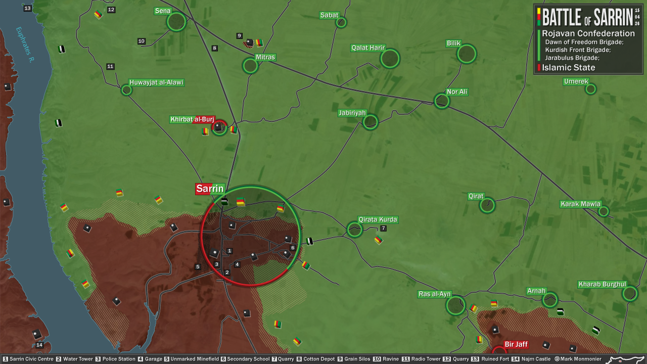
Sarrin under YPG control
On April 25, reliable source Jack Shahine reported that YPG/FSA entered Sarrin and fought ISIS in the town.
https://mobile.twitter.com/jackshahine/status/592083393103409152
Relying on Jack Shahine's report, Chuck Pfarrer reported that Khirbet al Burj was under YPG control.
https://mobile.twitter.com/ChuckPfarrer/status/592098005035122689/photo/1
I suggest that based on these reports, Sarrin be changed to contested between YPG and ISIS, and Khirbet al Burj be changed to YPG control. 2601:0:B200:F7D9:4831:6879:2CA4:C5A2 (talk) 15:45, 26 April 2015 (UTC)
- 2601:0:B200:F7D9:4831:6879:2CA4:C5A2 Chuck Pfarrer it is pro Kurdish source. Hanibal911 (talk) 16:13, 26 April 2015 (UTC)
IS sources report the city has repelled the YPG assault. Also Chuck Pfarer has been wrong before due to misinformation by Jack Shahine. Since IS is also launching still a counter-attack, I suggest not making any changes till we have corroborating evidence. Tgoll774 (talk) 17:29, 26 April 2015 (UTC)
- Jack Shahine is a reliable source. We have used him to show Kurdish advances before, he is one of our only neutral sources for that. Besides, pro-IS sources will never report their defeat. They always lie.
Also here are other sources:
https://mobile.twitter.com/Feeney4Batman/status/592326934442463232 2601:0:B200:F7D9:4831:6879:2CA4:C5A2 (talk) 18:48, 26 April 2015 (UTC)
- Jack Shahine has been wrong before and IS always reports its defeats.
That said https://pbs.twimg.com/media/CDi1C68WoAALYPi.png:large This shows YPG clearly on the outskirts of Sarrin and Khirbat al-Burj being contested http://36.media.tumblr.com/9d4d9473c2da3d0b3dfd12929f2c5bac/tumblr_nnggncZnLy1svp8ywo1_500.png Chuck Pfarer shows YPG halted on outskirts.
So Sarrin should switch to besieged, but not contested Tgoll774 (talk) 12:04, 27 April 2015 (UTC)
https://pbs.twimg.com/media/CDnp-DoWYAARGJd.jpg Fighting still on outskirts and Khirbat al-Burj still contested. Tgoll774 (talk) 13:20, 28 April 2015 (UTC)
http: //justpaste. it/kvl8 Sarrin is clearly not contested and IS sources state they pushed YPG back and geolocation confirms this is Sarrin. Tgoll774 (talk) 10:39, 2 May 2015 (UTC)
IS claims to have retaken Mitras and Murrabba in this sector https://twitter.com/ActivstMedia999/status/596005854031126528, also a lot of fighting seems to b going on throughout Syria as well with IS hitting Deir Ezzor and Kuwheires as well. Leave it to you guys to corroborate, but it looks like IS Summer Offensive is starting. Tgoll774 (talk) 01:48, 7 May 2015 (UTC)
Sarrin is not contested, repeated photos from the area show YPG is well outside the city having been repulsed. Even YPG sources are saying they been repulsed Tgoll774 (talk) 11:39, 7 May 2015 (UTC)
https://7496bff410df41fc380ad565a50f607d4b1e8372.googledrive.com/host/0BzN49CdHSAwmcGU4eEI5dVBGZXM/KobaniCantonEN-2015-05-10.png Pro-Kurd source confirming a successful IS counterattack in the North. Tgoll774 (talk) 16:10, 10 May 2015 (UTC)
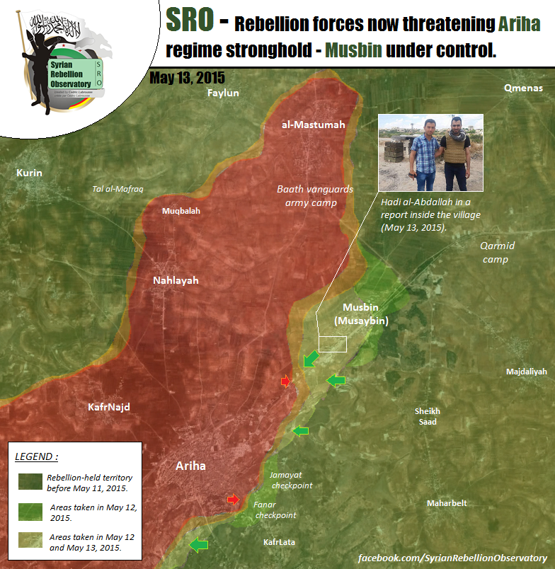
Musaybeen
The Syrian Army (Regime) defense line was collapsed. The Regime forces retreated to Ariha.
https://www.youtube.com/watch?v=KdyxE7P9p40&feature=youtu.be
http://inagist.com/all/595549109974601728/
http://documents.sy/image.php?id=2291&lang=en
Buthaina hill was captured by the Opposition:
http://wikimapia.org/#lang=tr&lat=35.830792&lon=36.641250&z=15&m=b
https://www.youtube.com/watch?v=-SoGMHgiEoA&feature=youtu.be
After liberation of Buthaina hill: https://www.youtube.com/watch?v=bLPbrCFHnyc 212.174.38.3 (talk) 06:28, 6 May 2015 (UTC)
- This just a data from pro opposition sources and we cant use him for displayed success of rebels. Need confirmation from the reliable or pro government sources. According to the rules of editing we cant use pro opposition sources and amateur video from rebels for displayed success of rebels. Hanibal911 (talk) 07:43, 6 May 2015 (UTC)
- I am trying to find neutral sources. Since the news is very new, it is cumbersome.
- I am trying to find neutral sources. Since the news is very new, it is cumbersome.
http://www.reddit.com/r/syriancivilwar/comments/34yin7/musaybeen_is_freed_from_assad_rule_for_now_rebel/ 212.174.38.3 (talk) 08:52, 6 May 2015 (UTC)
- But why you publish another data from pro opposition sources. We have enough data from the pro opposition sources and now need find confirmation from the reliable(neutral) sources. Hanibal911 (talk) 09:07, 6 May 2015 (UTC)
- I cannot differentiate which source is Loyalist which one is pro-opposition. I add more since one may know/aware one of them is neutral.212.174.38.3 (talk) 09:19, 6 May 2015 (UTC)
- But why you publish another data from pro opposition sources. We have enough data from the pro opposition sources and now need find confirmation from the reliable(neutral) sources. Hanibal911 (talk) 09:07, 6 May 2015 (UTC)
- Also pro government source reported that Syrian troops control village of Musaybeen and with the support of NDF advanced to the strategic hill overlooking on this village, where they continued their counter-offensive geared to recapture the territory which they lost near the Qarmeed Camp (Brick Factory) and that this attack was successful for the Syrian troops and NDF, as they secured the hill of Tal Masayabeen.Al Masdar So at the moment we have conflicting data. So we need find confirmation from a neutral source. Hanibal911 (talk) 10:20, 6 May 2015 (UTC)
- Opposition conquered msibin: http://www.syriahr.com/en/2015/05/the-nusra-front-rebels-and-islamic-battalions-seizes-msibin/ 212.174.38.3 (talk) 10:00, 13 May 2015 (UTC)
SAA-IS clashes at Deir Ezzor city
According to reliable pro-govt source Hassan Ridha clashes ongoing in the Sinaa neighborhood of Deir Ezzor:
https://twitter.com/sayed_ridha/status/596227607164661760
SOHR also reports about it:
So would it be ok to change the area to contested in detailed map? — Preceding unsigned comment added by 179.32.116.216 (talk) 11:15, 7 May 2015 (UTC)
- But for now on detailed map the Al-Hawiqah marked as contested and part of Al-Sina'ah also marked as contested. Hanibal911 (talk) 11:33, 7 May 2015 (UTC)
https://www.youtube.com/watch?v=HL7VI8H6Q4Y&feature=youtu.be IS vid documenting their gains in Deir Ezzor. Tgoll774 (talk) 22:39, 11 May 2015 (UTC)
https://drive.google.com/file/d/0B8iWfaWs28yGRXRqTFFCTjN3ZXM/view Neutral source. Tgoll774 (talk) 02:12, 16 May 2015 (UTC)
YPG advances in Tal Tamr
PKK aligned media has claimed that YPG captured 8 villages and several hamlets following fierce clashes today:
Elmaha, Dişo, Siraç, Hela, Behama, Effan, Keşke and Gişat villages, Rezazê hill plus 4 hamlets which are reportedly all near Aliyah.
Furthermore, SOHR confirmed their progress:
While at the southwestern front, reliable Hassan Ridha has reported that YPG is clashing with ISIS at Tal Nasri, Twain and Aghbish:
https://twitter.com/sayed_ridha/status/596226642793533440
____
So, for the advance near Aliyah it's gonna be hard to put the villages in since they're probably their kurdish names and not the arabic ones that are present here or at wikimapia, can anyone help here?
For the situation at southwest/south Tal Tamr however I guess we can switch the mentioned villages to contested since Hassan is reliable source, opinions?
Edit: Hardline pro-IS source admits capture of two villages at rural Serekaniye/Ras al Ayn: Ghishqa and Hillah
https://twitter.com/QHTANIYAH/status/596257332985737216 — Preceding unsigned comment added by 179.32.116.216 (talk) 11:39, 7 May 2015 (UTC)
179.32.116.216 (talk) 11:25, 7 May 2015 (UTC)
- 179.32.116.216 Where located these villages. You can indicate they coordinates. Hanibal911 (talk) 12:25, 7 May 2015 (UTC)
- Pro ISIS source reported that ISIS withdraw from 5 villages in the Ra's Al-Ayn countryside after heavy airstrikes.here Hanibal911 (talk) 19:38, 7 May 2015 (UTC)
- Bahima: http://wikimapia.org/#lang=en&lat=36.671538&lon=40.000051&z=17&m=b
- Malha: http://wikimapia.org/#lang=en&lat=36.652764&lon=39.984312&z=17&m=b
- Qashqa: http://wikimapia.org/#lang=en&lat=36.630338&lon=40.026047&z=16&m=b
- Hayla: http://wikimapia.org/#lang=en&lat=36.620462&lon=39.997594&z=16&m=b Roboskiye (talk) 20:28, 7 May 2015 (UTC)
Thanks for your help Roboskiye and Hanibal!
According to reliable pro-oppo al Qasion news the -probably arabic- names of the villages liberated are these: Al-malha, Aldeshu, sraj, hiala,alkasha, Aallon, Akoshat, and Razzazah
https://www.facebook.com/photo.php?fbid=828879927197729
Did you find any of these when at wikimapia, Roboskiye? Maybe it could be helpful since the names posted by pro-ypg sources are oftne in kurdish.
- Note that while the name "National Protection Units" is used the photo in the top is clearly of kurdish forces and if they meant NDF they wouldn't have said "Protection Units" which is part of YPG's "People's Protection Units", so it's obviously faulty translation.
179.32.116.216 (talk) 02:09, 8 May 2015 (UTC)
YPG has claimed to be in control of the villages of
Nevermind, this map by Res Publica shows the two villages captured by YPG we've not market yet, Muqeren and al-Nawfaliyah:
https://twitter.com/_paulo34/status/596354890059907072
I would suggest putting them under YPG control, and while his map does show the countryside between the captured villages and Manajir as YPG controlled, I suppose it'd be better to wait for more sources before turning the newly formed IS pocket into yellow, your thoughts? 179.32.116.216 (talk) 03:27, 8 May 2015 (UTC)
__________________________________________________
According to kurdish media YPG has taken control of the villages of Tal Majdal and Ashrah supported by coalition airstrikes and posting video footage:
https://www.youtube.com/watch?v=YbDp9arEWCo https://www.youtube.com/watch?v=WqfUO9SEawM
Pro-govt twitter confirms at least the liberation of Tal Majdal:
https://twitter.com/ResistanceER/status/596682394901569538
The villages can be found here:
While pro-govt and pro-kurdish sources aren't enough for making a change like this, it would be helpful if anyone could post info from neutral sources so the situation can be confirmed or not.
179.32.116.216 (talk) 16:06, 8 May 2015 (UTC)
- Based on videos and pics on pro-YPG media, it appears that YPG is just a few km north of Mount Abdulaziz.
- Video: http://en.hawarnews.com/newroz-martyrs-revenge-operation-in-til-temir/
- Photos: http://hawarnews.com/%D9%85%D9%86-%D9%88%D8%AD%D8%AF%D8%A7%D8%AA-%D8%A7%D9%84%D8%AD%D9%85%D8%A7%D9%8A%D8%A9-%D8%AD%D9%85%D9%84%D8%A9-%D8%A7%D9%86%D8%AA%D9%82%D8%A7%D9%85-%D9%84%D8%B4%D9%87%D8%AF%D8%A7%D8%A1-%D9%86%D9%88/
- On map: http://wikimapia.org/#lang=en&lat=36.507153&lon=40.456220&z=17&m=b
- On map: http://wikimapia.org/#lang=en&lat=36.505937&lon=40.485370&z=17&m=b
- On map: http://wikimapia.org/#lang=en&lat=36.506122&lon=40.393907&z=17&m=b Roboskiye (talk) 18:06, 8 May 2015 (UTC)
- SOHR seems to confirms the YPG advance mentioned by Roboskiye http://www.syriahr.com/2015/05/الوحدات-الكردية-تتقدم-مجدداً-في-ريف-تل/ , any opinions? — Preceding unsigned comment added by 179.32.116.216 (talk) 18:52, 8 May 2015 (UTC)
- Pro ISIS source reported that Regime takes Tel Mejdal and 2 other villages after heavy bombing coalition Air Force.here So that probably YPG and Syrian troops to jointly recaptured these villages. Hanibal911 (talk) 19:43, 8 May 2015 (UTC)
- SOHR seems to confirms the YPG advance mentioned by Roboskiye http://www.syriahr.com/2015/05/الوحدات-الكردية-تتقدم-مجدداً-في-ريف-تل/ , any opinions? — Preceding unsigned comment added by 179.32.116.216 (talk) 18:52, 8 May 2015 (UTC)
- Hanibal the villages mentioned by Roboskiye whose capture was confirmed by SOHR aren't nowhere near Tal Majdal but way more to the west (easily seen in wikimapia) and they have only been claimed to be captured by YPG so they should be marked yellow only.
- Regarding the joint recapture of Tal Majdal and nearby areas I don't know if pro-ISIS sources are reliable enough for joint YPG-SAA control, these sources often try to make YPG look as a SAA pawn and often are not a good indicative of whether there is joint control or not, like when they claimed Tal Brak was under joint control when the govt forces were only at the highway leading to it. 190.67.43.88 (talk) 20:03, 8 May 2015 (UTC)
Ok the Tal Majdal issue has been solved at the West Hasakah subsection but could someone do the edits posted by Roboskiye? SOHR confirmation and video footage from YPG should be enough.
190.67.43.88 (talk) 21:01, 8 May 2015 (UTC)
Hanibal911 as of the latest revision you used CCnews map to edit some yellow dots back to black but that wasn't the most recent version of his map, you have to click here:
And you will see that Aliya is clearly contested as it was earlier.
Also in the same map that Tal Majdal is neither under kurdish nor under govt control, which can be verified since:
1. YPG's website claims first that the village is under their control but afterwards says clearly that they are ongoing: http://ypgrojava.com/en/index.php/statements/638-cizire-and-kobane-five-more-villages-liberated-through-unwavering-operations
2. Pro-IS sources (including @QNTANIYEH which has been since suspended by twitter) have claimed a counterattack in which they recaptured the village of Tal Majdal: http://www.azzammedia.net/berita-daulah-khilafah-islamiyah-islamic-state/counter-attack-pkk-tal-dibs/
Given how YPG claims contested, pro-kurdish CCnews claims IS control and pro-IS claim IS control I say it should be switched to black, your thoughts?
186.119.58.15 (talk) 20:25, 9 May 2015 (UTC)
- YPG in control of Tal Majdal: Video: https://www.youtube.com/watch?v=qjNfPF8XSqc
- YPG just about 1 or 2 km away from Mount Abdulaziz (Mount Kezwan). The cars coming on the mount are easily visible, as are even the trees countable: http://firatnews.com/kurdistan/salihiye-koyu-cevresinde-catismalar-siddetleniyor Roboskiye (talk) 20:57, 9 May 2015 (UTC)
Syrian army and Hezbollah advanced in Qalamoun.
Syrian troops and Hezbollah seize 5 strategic hills in Qalamoun.The Daily Star SOHR also reported that Syrian troops, NDF and Hezbollah take control the control of the hills near Assal al-Ward and Al-Juba after violent clashes with Al-Nusra.SOHR Also reliable source reported that Syrian troops and Hezbollah completed their control of Assal al-ward and hills on outskirts.Elijah J. Magnier Syrian troops and Hezbollah seized control of several hilltops in a mountainous area that straddles the Syria-Lebanon border. Syrian troops and allies had advanced around Assal al-Ward, a small regime-controlled village near the Lebanese border.Al ArabiyaAl ArabiyaReutersThe Worls BulletinDemanjoIsrael National NewsThe NationalThe Jerusalem PostHaaretz Hanibal911 (talk) 16:28, 7 May 2015 (UTC)
- SOHR said that Hezbollah backed by Syrian forces take control strategic heights in the Syrian region of Qalamoun that abuts Lebanon's eastern border. The control of the area on the outskirts of Assal al-Wared came following heavy clashes with al-Qaida linked al-Nusra Front.Naharnet Hanibal911 (talk) 17:47, 7 May 2015 (UTC)
- Another article about this battle dailystar Hezbollah and Syrian troops seized five “strategic hills” in the eastern part of Qalamoun, taking control over the towns of Assal al-Ward and Al-Juba, the sources said. The Islamist militants had seized the two towns in previous battles (probably outskirts). Acording Naharnet Hezbollah and the Syrian Army succeeded in linking Syria´s Assal al Ward with Lebanon´s town of Brital and one more source sayed_ridha Hezbollah has complete control of 45km2 area in the Asal Al-Wared area. — Preceding unsigned comment added by 217.99.136.16 (talk) 23:02, 7 May 2015 (UTC)
Hanibal911 where are these hills ? can they be added to map and should JAN presence icon be taken away or repositioned .86.178.102.112 (talk) 14:10, 8 May 2015 (UTC)
- Rebels reported that they tactical withdraw from area of Assal al Ward. And these data indirectly confirm the information on the control of the Syrian troops and Hezbollah on this area including the five hills.hereHala Jaber Hanibal911 (talk) 15:20, 8 May 2015 (UTC)
- Probably Amin_Akh south. 217.99.75.51 (talk) 16:28, 8 May 2015 (UTC)
According to rebel map (gyshfathqalamon) JAN has withdrawn north to the Homs border area .86.178.102.96 (talk) 16:35, 8 May 2015 (UTC)
- Hezb+SAA take more and more area, acording ynetnews the army and Hezbollah were in control of around 100 sq km (40 sq miles). ResistanceER said about this area: here here and here 217.99.75.51 (talk) 17:10, 8 May 2015 (UTC)
- And pro gov TV video 217.99.75.51 (talk) 21:05, 8 May 2015 (UTC)
- Pro opposition source reported that the rebels do tactical withdrawal from their positions and that the military command of rebels decided to adhere guerrilla war and not to stay in any point, so as to avoid Syrian air strikes, and as much as possible reduce casualties.Al Araby Hanibal911 (talk) 21:13, 8 May 2015 (UTC)
- And pro gov TV video 217.99.75.51 (talk) 21:05, 8 May 2015 (UTC)
Map of qalamoun(pro gov)https://twitter.com/sayed_ridha/status/596654683151826944/photo/1 Talat Musa should be added, that's the most important mountain, most of the rebels/nusra is there.Totholio (talk) 08:34, 9 May 2015 (UTC)
- Totholio This object already present on the map. Hanibal911 (talk) 08:54, 9 May 2015 (UTC)
West to Flitah? It's not showing the name.Totholio (talk) 08:34, 10 May 2015 (UTC)
- Here Lebanese TV station showed that Syrian troops and Hezbollah captured 100 square km. of area in west Qalamoun.LBCI News Hanibal911 (talk) 09:03, 9 May 2015 (UTC)
According EjmAlrai and PetoLucem map: "#JN and rebels are all in Talat Musa where the biggest battle is expected in the future in #Qalamoun". In this moment rebel in Zabadani are totaly cut off from supply 217.99.75.51 (talk) 09:52, 9 May 2015 (UTC)
- More and more territory take by Hezbollah + SAA here and here 217.99.75.51 (talk) 13:20, 9 May 2015 (UTC)
- Hanibal911 who changed the rural presence icon from rebel held to regime held and also removed the Isis presence icon???Here is a new map from pro-regime sources that shows that they have still presence in those areas!Lindi29 (talk) 15:30, 9 May 2015 (UTC)
- Lindi29 I fix this on map. Hanibal911 (talk) 16:39, 9 May 2015 (UTC)
- Hanibal911 who changed the rural presence icon from rebel held to regime held and also removed the Isis presence icon???Here is a new map from pro-regime sources that shows that they have still presence in those areas!Lindi29 (talk) 15:30, 9 May 2015 (UTC)
Many hill and small village capture by Hezbollah and SAA herehere here and here. According this video around 150 JN fighters died in the battle of Qalamoun overall. 217.99.121.133 (talk) 13:57, 11 May 2015 (UTC)
- And something about neutral source EjmAlrai Hezbollah is attacking Ras al-Maarra and extending its control over one section of Qalamoun, although d Qalamoun battle hasn't started yet 217.99.121.133 (talk) 13:59, 11 May 2015 (UTC)
- Source mention that they attacked rebels in area of Ras al Mara and take control this area. Because town of Ras al Mara long time is under control a Syrian troops. Hanibal911 (talk) 14:51, 11 May 2015 (UTC)
- I know that, all article is not precise, because this area it is outskirt of this city/village. Another article dailystar The clashes erupted after Hezbollah and the Syrian army seized control of the Al-Barouh hill Monday morning. They are also trying to advance on a nearby hilltop known as Tallit Moussa, one of the highest positions in Qalamoun. Tallit Moussa overlooks the outskirts of Arsal, and would allow Hezbollah and the Syrian army to monitor militant movements in the area. — Preceding unsigned comment added by 217.99.121.133 (talk) 22:18, 11 May 2015 (UTC)
- Another progress dailystar Hezbollah advances and capture Mashrouh Haql Zeaiter hilltop and area of Jour Beit Abdel Haqq plus JAN declaring war on #IS in Qalam 217.99.132.128 (talk) 12:45, 12 May 2015 (UTC)
- Update dailystar Hezbollah and SAA captured three hills today. Jihadis fled to strategic hill Talit Moussa. Battle for Talit Moussa coming. Pro Israel source said about big progress SAA+Hezb jpost 217.99.132.128 (talk) 18:08, 12 May 2015 (UTC)
- Another progress dailystar Hezbollah advances and capture Mashrouh Haql Zeaiter hilltop and area of Jour Beit Abdel Haqq plus JAN declaring war on #IS in Qalam 217.99.132.128 (talk) 12:45, 12 May 2015 (UTC)
- I know that, all article is not precise, because this area it is outskirt of this city/village. Another article dailystar The clashes erupted after Hezbollah and the Syrian army seized control of the Al-Barouh hill Monday morning. They are also trying to advance on a nearby hilltop known as Tallit Moussa, one of the highest positions in Qalamoun. Tallit Moussa overlooks the outskirts of Arsal, and would allow Hezbollah and the Syrian army to monitor militant movements in the area. — Preceding unsigned comment added by 217.99.121.133 (talk) 22:18, 11 May 2015 (UTC)
- Source mention that they attacked rebels in area of Ras al Mara and take control this area. Because town of Ras al Mara long time is under control a Syrian troops. Hanibal911 (talk) 14:51, 11 May 2015 (UTC)
This is huge. EjmAlrai Hezbollah took full control of the strategic hill of Tallat Mussa in Qalamoun battle. 217.99.132.128 (talk) 12:24, 13 May 2015 (UTC)
- dailystar and reuters confirm this. The advance pushed surviving militants towards the outskirts of Arsal, namely the areas of Wadi al-Rahwe and Wadi Hmeyed. Militants also withdrew towards Tallit Njasa, located on the outskirts of the Lebanese town of Ras Baalbek. 217.99.132.128 (talk) 13:51, 13 May 2015 (UTC)
- According EjmAlrai Fierce battle ongoing between Hezbollah and JN in Flita outskirt NOW. Many rebels wounded reached Arsal hospital Lebanon and EjmAlrai Hezbollah completed control of around 6sqkm Dahr al-Hawa hill overlooking Arsal & Yanoun outskirts tt was under JN. 217.99.132.128 (talk) 15:48, 14 May 2015 (UTC)
- According dailystar Hezbollah and the Syrian army seized full control from jihadis Friday of Jabal al-Barouh in the Qalamoun region overlooking the highway linking Damascus to Homs 217.99.132.128 (talk) 09:39, 15 May 2015 (UTC)
- According EjmAlrai Fierce battle ongoing between Hezbollah and JN in Flita outskirt NOW. Many rebels wounded reached Arsal hospital Lebanon and EjmAlrai Hezbollah completed control of around 6sqkm Dahr al-Hawa hill overlooking Arsal & Yanoun outskirts tt was under JN. 217.99.132.128 (talk) 15:48, 14 May 2015 (UTC)
Qalamoun map
It seems that the Petolucem map https://twitter.com/PetoLucem/status/597056863042203648 is too favourable to the rebels! In the comment jayrud to rebels is questioned and there is no evidence of the truce being broken. It should stay on truce.Paolowalter (talk) 19:09, 9 May 2015 (UTC)
- Agree! His map is contrary to all data from the rebels and from reliable sources. Many realiable sources confirmed that many area recaptured Syrian troopsThe Daily StarSOHRElijah J. MagnierAl ArabiyaAl ArabiyaReutersThe Worls BulletinDemanjoIsrael National NewsThe NationalThe Jerusalem PostHaaretzynetnewsNaharnetThe Daily Star and rebels reported that they tactical withdrawal from their positions and that the military command of rebels decided to adhere guerrilla war and not to stay in any point, so as to avoid Syrian air strikes, and as much as possible reduce casualties.hereHala JaberAl Araby Lebanese TV station showed that Syrian troops and Hezbollah captured 100 square km. of area in west Qalamoun.LBCI News According to reliable source Elijah J. Magnier all Rebels and Al Nusra for now located in Talat Musa in Qalamoun where in the future is expected a biggest battle. So that the map displays erroneous information. Hanibal911 (talk) 20:02, 9 May 2015 (UTC)
- Thank you for finding all that information. This is indeed weird, since even pro-opp DeSyracuse expressed surprise at peto's map. Many people are asking him for clarification and I am sure he will respond to that. It should clear up the situation.XJ-0461 v2 (talk) 21:04, 9 May 2015 (UTC)
Hanibal911 Sorry Hanibal but you are obviously trying to avoid the rules in a way of showing dozens of sources just for a quantity, but it doesn't help because, unlike other, i read all of them.
- Most of them are using Pro-government or Pro-Lebanon sources in their articles.
- Others use SOHR, but why did you post them if you already posted SOHR as one of those links ? It's not all about quantity.
- EliahMagnier quoted a pro-government source, basically the same text is written on their sites. I do agree with SOHR and some of those sources, because government forces did advance, basically what PetoLucem map is showing, because rebels were in the vicinity of Assal Ward/Falita/Jubah, and now they are pushed way back.
Can you just write again what should not be changed, according to his map, (without posting sources for now), and we will see then. DuckZz (talk) 21:05, 9 May 2015 (UTC)
- DuckZz Pro opposition source clear said that rebels tactical withdrawal from their positions and that the military command of rebels decided to adhere guerrilla war and not to stay in any point, so as to avoid Syrian air strikes, and as much as possible reduce casualties.Hala JaberAl Araby But also I agree with you that rebels still have some forces in W-Qalamoun but not such as this showed Petro Lucem. Also for now we not have the data from the neutral or pro government sources except Petro Luce which confirmed that Jayroud under control Al Nusra probably this town still under truce. But on this occasion a lot of questions. Hanibal911 (talk) 21:18, 9 May 2015 (UTC)
Hanibal911 Yes but i don't know what do you want to say. What do you want to be changed on our map ?? Your twitter source says that rebels withdrew from the area that borders with Lebanon. And as you can see, we removed the rural presence icon in that area and added specific hills. You remember when i said last year, and in this year that Jayroud is controled by rebels, and i posted dozens of opposition sources, including videos, but you sad that we need to wait for more info. The town stayed as under government control. Neutral sources did not post infos about this town because there were no clashes, but that doesn't mean it's under a truce. Now Peto shows it under rebel control, of course as Al Nusra, but we will put a joint rebel control, i don't see a problem here ... DuckZz (talk) 21:35, 9 May 2015 (UTC)
- DuckZz It is I put on the map some hills which under rebel control, and Al Nusra. And for now I found another pro government source here which showed that for now our map correctly showed situation in W-Qalamoun. And for now I dont want change nothing in W-Qalamoun. But in situation with the town of Jayoud, still have the some doubts. Hanibal911 (talk) 21:51, 9 May 2015 (UTC)
Hanibal911 But this shouldn't surprise you. Remember for how long was Kafr Shams showed as under government control ? For more than a year. There were no clashes, so no neutral reports were about that town, but then we found out that rebels have the full control. The same for Latakia area, Madaya etc. We have the same situation in Kanaker (north Daraa) where rebels say that they control it, with a truce, and even Petolucem showed once that town under rebel control, but then changed it back to red on the next map.
- Petolucem was maybe wrong, he did not showed Jayrud under a truce, but opposition sources say that it is, the same as Dumayr and Ruhayban, showed on this pro-opp map DuckZz (talk) 22:19, 9 May 2015 (UTC)
- DuckZz Kanaker under control by Syrian troops and this confirmed pro governmentherehere sources and neutral source here and Ruhaybe and Dumayr under truce(jointly control) Hanibal911 (talk) 06:07, 10 May 2015 (UTC)
- Peto Lucem has made a map that's favorable to the Rebels? I thought I would never see the day. Next, you're gonna say that Thomas van Linge's gonna make a map favorable to the Regime. — Preceding unsigned comment added by 76.126.188.171 (talk) 06:31, 10 May 2015 (UTC)
Removing green dot in Kobanê
Why there is still a green dot in Kobanê as well as the nearby villages of Kulmad and Shêran? The FSA left the city and these two villages already in January, when the frontline was shifted to villages far away from the city. Roboskiye (talk) 10:20, 10 May 2015 (UTC)
You don't quite well understand how the map works. I bet 70% of the villages in Kobane area are empty, because obviously YPG needs like 60 000 soldiers to have 24h presence in all of them. We mark villages according to sources who captured them, and how. Of course we also change the situation if a group leaves a town, and another groups captures it. But as we have a joint force situation in Kobane, it's not important to know if a group still has presence in a specific village, because they captured it, and they both move on. Kobane town for example has still rebel presence as FSA Col.Okaidi and (rumours Jamal Marouf) made a HQ in that town. DuckZz (talk) 15:28, 10 May 2015 (UTC)
Okaidi fled the town after a few days visit realizing ISIS is too strong for him to resist. Jamal Marouf presence turned out to be just a rumor. The Sunni/Green presence in Kobanê was not for joint control of the town, rather to use Kobane soil as base for attacks on ISIS who occupies Arab villages around Kobane. Roboskiye (talk) 15:38, 10 May 2015 (UTC)
- DuckZzRoboskiyeThis Kurdish source sometimes showed wher YPG/rebels jointly fight against ISIS.hereherehere So his maps are sometimes very useful. So his maps a sometimes very useful for us. Hanibal911 (talk) 20:44, 10 May 2015 (UTC)
YPG advances against ISIS in Hasakah
Pro opposition source said that that YPG announced they take control the village of Tel Majdala in the western countryside of Hasakah, after heavy clashes with the Islamic State.ARA News video report from ARA News here Also pro Kurdish source reported that the clashes, which started yesterday in the village of Salihiye to the west of Haseke, are reportedly still continuing.ANF News Hanibal911 (talk) 13:15, 10 May 2015 (UTC)
So the village of Tal Majdal goes yellow or red-yellow? Don't think it can go red-yellow given how the source used to make the edit like that blatantly backtracked, specifically saying "YPG attack":
https://twitter.com/QHTANIYEH1/status/596782195009814528
About Salihiya, does anyone knwo hwere it is located to put the contested dot?
186.119.58.15 (talk) 14:50, 10 May 2015 (UTC)
- YPG sources have during this recent operation talked about two villages named Salihiya:
- One west of Hasaka: http://wikimapia.org/#lang=en&lat=36.506368&lon=40.393789&z=18&m=b
- The other west of Tal Tamer: http://wikimapia.org/#lang=en&lat=36.601608&lon=40.093719&z=18&m=b Roboskiye (talk) 15:41, 10 May 2015 (UTC)
I turned again Tal Majdal red-yellow as agreed few days ago. If there are reliable news that it should go yellow, we can change. (Who turned it black?)Paolowalter (talk) 17:51, 10 May 2015 (UTC)
Hanibal turned it black because yesterday reliable mapmaker CCNews/Cetin had it marked black in his map and IS had announced the recapture of the town while YPG retracted and said that it was contested -you can see in the Tal Tamr section above-, today YPG has again claimed it's captured and posted footage with no indication that SAA participated aside from the @QHTANIYEH1 guy who has previously claimed that both FSA and Hezbollah are present at Rasulain/Serekaniye countryside.
190.67.234.251 (talk) 18:28, 10 May 2015 (UTC)
- Kurdish source reported that YPG/YPJ/MFS forces have taken control over the International highway between Cizîre and Aleppo, 35 km west of Tal Tamir.Cahida Dêrsim Hanibal911 (talk) 20:29, 10 May 2015 (UTC)
- Also pro-IS source has claimed to take over Al Rawiya near Tal Khanzir so it should go contested? https://twitter.com/mediaactivst37/status/597504062037295105 190.67.234.251 (talk) 21:04, 10 May 2015 (UTC)
Kurdish source claims YPG-YPJ captured Salihiyah west of Hasaka: https://twitter.com/curdistani/status/597519410493001728
SOHR confirms advancement for YPG in the area:
http://www.syriahr.com/2015/05/اشتباكات-عنيفة-وانفجارات-في-عدة-مناطق/
190.67.234.251 (talk) 23:43, 10 May 2015 (UTC)
- Pro government source also reported that YPG captured vilage of Salihiyah.here Hanibal911 (talk) 07:15, 11 May 2015 (UTC)
- Kurdish source reported that the Highway M4 and village of Al Salihiyah under control by YPG/YPJ.Cizire Canton News Hanibal911 (talk) 13:36, 11 May 2015 (UTC)
- Hanibal911 since when did we start using pro-kurdish and pro-opp sources in favor for kurds??? There are like 3 or 4 kurd editors who are vandalizing the map beacasue they are editing with pro-kurd sources??.Lindi29 (talk) 17:23, 11 May 2015 (UTC)
- Lindi29 I always was opposes such actions but some editors ignored the rules of editing map. We can use this sources if they data confirmed reliable sources or pro-ISIS in clashes against ISIS or pro opposition in clashes against rebels/JAN and pro government in clashes against Syrian troops. Hanibal911 (talk) 17:34, 11 May 2015 (UTC)
- Hanibal911 Not the first time that they are vandalizing the map,they should explain why are they editing with pro-kurd and pro-opp source to show kurds advances,if not then they should be warned or banned.Lindi29 (talk) 17:37, 11 May 2015 (UTC)
- Pro-oppo sources like SOHR or Qasion News are in no way pro-kurdish and I don't see why their use should be banned regarding kurdish gains which is what has been done recently, at Kobane? Maybe, but at Hasakah province where they have truces with SAA and no collaboration with rebel groups I don't see how their reports would be biased, if we ban the use of oppo sources then we would have to ban the use of govt sources (Leith Fadel reports YPG gains in a possitive light) and then only highly propagandistic (even moreso than sources from all the other parties, look at how they've falsely claimed 70% of Kweires like a week ago) IS sources would remain.
- Also it would be good if you refrained from accusing others of vandalism without justification as that's clearly against Wikipedia guidelines: en.wikipedia.org/wiki/Wikipedia:Vandalism , here are SOHR reports that confirm YPG advances: http://www.syriahr.com/2015/05/استمرار-الاشتباكات-في-ريف-تل-تمر-وقذائ/http://www.syriahr.com/2015/05/أكثر-من-43-جثة-لعناصر-تنظيم-الدولة-الإسل/
190.67.234.251 (talk) 17:58, 11 May 2015 (UTC)
- Hawarnews reports more villages taken over by YPG in recent hours: Tel Tal, Buwayda, Mushayrafa, Izam, Ashra, Khanat etc all of which located west of city of Hasaka:
- http://hawarnews.com/%D8%AA%D8%AD%D8%B1%D9%8A%D8%B1-4-%D9%82%D8%B1%D9%89-%D9%85%D9%86-%D9%85%D8%B1%D8%AA%D8%B2%D9%82%D8%A9-%D8%AF%D8%A7%D8%B9%D8%B4/
- http://hawarnews.com/%D8%AA%D8%AD%D8%B1%D9%8A%D8%B1-%D9%82%D8%B1%D9%8A%D8%A9-%D8%B9%D8%B4%D8%B1%D8%A9/ :http://hawarnews.com/%D8%AA%D9%85-%D8%AA%D8%AD%D8%B1%D9%8A%D8%B1-%D9%82%D8%B1%D9%8A%D8%A9-%D8%AE%D8%A7%D9%86%D8%A7%D8%AA/ Roboskiye (talk) 17:55, 11 May 2015 (UTC)
- Roboskiye YPG and FSA are fightning Isis together?? Am I wrong ?? Haranews is a pro-kurd and pro-opp source.SOHR doesn't mention any captured territory only fightning in that area.Lindi29 (talk) 21:53, 11 May 2015 (UTC)
Al Manshara and Debes Checkpoints in Jesr Al Shoughour
Rebel sources claiming shelling of the Manshara CP and taking over Debes CP. This means both checkpoints are SAA held at the moment. [1] [2] ChrissCh94 (talk) 15:20, 10 May 2015 (UTC)
- Reliable source reported that today the clashes continued into the early hours where earlier the rebels retakes some checkpoints from the Syrian troops before being pushed back.Daily Mail Also Syrian TV channel Ikhbariyah reported that today Syrian troops advanced and the tighten their control on the several points and that for now troops a short distance from the city of Jisr al Shughur.Al Ikhbariyah Hanibal911 (talk) 11:41, 11 May 2015 (UTC)
- Also pro opposition source reported that the Regime forces retook Al-Klarin & Sawmill Checkpoint and for now troops stand near sugar factory.here Hanibal911 (talk) 11:44, 11 May 2015 (UTC)
- SOHR also reported that the Syrian troops recaptured two checkpoints near the sugar factory.SOHR Hanibal911 (talk) 11:46, 11 May 2015 (UTC)
- SAA recaptured the barriers(cp's) around Jisr al Shug. road and clashes ongoing around sugar factory and khattab IvanSidorenko1 photo on ground showing circumstance of Sugar Factory. According pro gov PetoLucem SAA took al-Mishrfeh, Tal Qintar and Tal Qartal areas and al laxes leading to Jisr_al_Shughour are now under fire control. Wait for confirmation and localization 217.99.121.133 (talk) 12:28, 11 May 2015 (UTC)
SAA in control of AlMintar and AlKhatab hills near Jisr AlShughour. Photos: here Stharkov (talk) 13:49, 11 May 2015 (UTC)
- These data from the pro government source and we wait confirmation this data from pro opposition or neutral sources. Hanibal911 (talk) 14:53, 11 May 2015 (UTC)
South and east of Tall Brak
The situation of villages to the south and east of Tal Brak has many times been discussed. Numerous pro-ISIS sources confirm that YPG hold those villages, including, Rajm Tufayhi, Qobur Fazil as far south as Tal Saman and Um Ghadir. Just google these names to find out how pro-ISIS sources complain of how badly YPG treates poor villagers in those villages! This edit is very unconstructive, siting an amateur map, itself based on various versions of this wikimap!! Please be kind and revert it. Roboskiye (talk) 17:41, 11 May 2015 (UTC)
- Roboskiye What sources confirmed that those villages under control by YPG. Because good Kurdish source which timely make update on map. He used data from many pro Kurdish sources and some other sources. Also some other pro Kurdish sources also showed that area where located these villages for now under control of ISIS.here herehere Hanibal911 (talk) 19:18, 11 May 2015 (UTC)
- As if my edit was not sourced. But in any case you come usually with various amateur versions of this wikimap, often outdated, ignoring all other sources provided. Roboskiye (talk) 15:43, 12 May 2015 (UTC)
Northern Aleppo Villages
Northern Aleppo Villages (Shehba, Hasin, Hassiye, Hasacik, Hoz) was captured by Jebhetu'sh Shamiiye. ISIL expelled from these villages. (Source: AA Agency, Turkey): http://www.aa.com.tr/tr/manset/508305--25-hizbullah-militani-olduruldu 212.174.38.3 (talk) 07:11, 12 May 2015 (UTC)
- This data from Hüseyin Nasır from the one of the commanders rebels. Thus they need to be confirmed from other sources. Hanibal911 (talk) 07:39, 12 May 2015 (UTC)
- Here data from another pro opposition source said that the rebels (Levant front) allegedly captured and recaptured today 5 ISIS held villages(Al Ghuz, Haseini, Hassajir, Sab Shahba, Al Hasia) in north of Aleppo, clashes ongoing.here Hanibal911 (talk) 07:56, 12 May 2015 (UTC)
- SOHR reported about clashes between rebels/Al-Nusra against Islamic State in the vicinity of Tel Mald village near city of Mare` and Dam Shahba and confirmed information on the progress of the rebels/Al-Nusra in bridging Shahba area.SOHR So that probably this is true that rebels/JAN advance in this area and take some villages. Hanibal911 (talk) 08:32, 12 May 2015 (UTC)
 Done I marked village of Al Ghuz as under control by rebels but four from these five villages long time marked as under control of rebels. Hanibal911 (talk) 09:22, 12 May 2015 (UTC)
- Pro opposition source later confirmed that the village of Al Ghuz still under control of ISIS.Archicivilians Hanibal911 (talk) 18:36, 12 May 2015 (UTC)
- SOHR reported about clashes between rebels/Al-Nusra against Islamic State in the vicinity of Tel Mald village near city of Mare` and Dam Shahba and confirmed information on the progress of the rebels/Al-Nusra in bridging Shahba area.SOHR So that probably this is true that rebels/JAN advance in this area and take some villages. Hanibal911 (talk) 08:32, 12 May 2015 (UTC)
- Here data from another pro opposition source said that the rebels (Levant front) allegedly captured and recaptured today 5 ISIS held villages(Al Ghuz, Haseini, Hassajir, Sab Shahba, Al Hasia) in north of Aleppo, clashes ongoing.here Hanibal911 (talk) 07:56, 12 May 2015 (UTC)
Jabhat al Nusra
How many times are you gonna do this? This is the third time I bring this to the discussion, after User:DuckZz and others fail to provide any evidence to support their claims that Nusra is all over the place. I am not going to repeat myself a third time, please undo your revert or I shall take this up to the administration. It is not *my* fault you lose interest in the topic quickly and move on, just don't monopolize the changes when you are not willing to prove your way. NightShadeAEB (talk) 11:01, 12 May 2015 (UTC)
- For those interested, here are the previous discussions:
- https://en.wikipedia.org/wiki/Talk:Cities_and_towns_during_the_Syrian_Civil_War/Archive_46#Jabhat_al_Nusra
- https://en.wikipedia.org/wiki/Talk:Cities_and_towns_during_the_Syrian_Civil_War/Archive_47#Jabhat_al_Nusra_control
- NightShadeAEB (talk) 11:05, 12 May 2015 (UTC)
NightShadeAEB It's no my fault because you don't want to understand the rules. You say "Ok, i want to change this town becasue JAN is either not there or has not the upper hand", but then you change dozens of villages if favor for JAN where you change it from lime to grey or grey-lime .... doesn't make any sense right ? You have a request ? No problem, post the specific village/town here and we can disquss about that, but not dozens at the same time, you can see the previous disqussing were unreadable due to different topics at the same sections. DuckZz (talk) 11:21, 12 May 2015 (UTC)
- By your own rules you do not have any proofs to keep them this way. I refuted Hannibal's methodology in discussion one, it is not my fault you are not prepared to read. I provided sources, and conducted a close reading on sources provided by Hannibal. Listen, you either involve in the discussion, or you don't involve in the reverts. There are no three ways around this. And why should I post one or two villages at a time? That's called spam. I have an issue, which is all related, and I'm tackling it. If you can't multi-task, please leave the reverts to someone who can, thank you. Again, I'm asking you to please undo your own revert, or I shall contact an admin about this. I can hardly be held accountable for someone refusing to read and engage what I post. NightShadeAEB (talk) 11:27, 12 May 2015 (UTC)
NightShadeAEB I have read the discussion again. As for me, you are free to change Mar'e and Marat Numan to joint control. DuckZz (talk) 12:14, 12 May 2015 (UTC)
- Thank you. What about Binnish and Ram Hamdan? Ram Hamdan was the site of the senior Ahrar al Sham meeting where all its leaders were assassinated, where one of the leaders was himself a native of Ram Hamdan. The reliance on PetoLucem's randomized maps for making Ram Hamdan a Nusra stronghold and Binnish a green stronghold is off, since there's no indication PetoLucem is even remotely accurate with his depictions on which group is where. However, since Ram Hamdan is next to other Nusra strongholds, I'd settle for keeping it joint control. As for Binnish, it was always a Nusra stronghold, and with the presence of Ahrar al Sham, Faylaq al Sham and Jaysh al Islam, should at least be joint control. Recently Nusra killed an Ahrar judge back in January, and this article says that Binnish has a "main presence" of Ahrar al Sham and Jabhat al Nusra both. [3] Another article lists Binnish as having once been the capital of Jabhat al Nusra before ISIS supplanted it. [4] Both papers are pro-rebel, but not necessarily pro-Nusra (in fact, likely hostile to Nusra, especially the Saudi owned Awsat). NightShadeAEB (talk) 15:33, 12 May 2015 (UTC)
Rebels capture Wadi Al-Azib checkpoint in north-east Hama
According to this article: http://syriadirect.org/news/rebels-assault-regime-supply-lines-in-hama-ahead-of-aleppo-showdown/ rebels captured the strategic important Wadi Al-Azib checkpoint in north-eastern Hama. The checkpoint is allready on the map, please change it to green. — Preceding unsigned comment added by 87.163.170.27 (talk) 20:01, 12 May 2015 (UTC)
- It is a pro-opposition source, which cannot be used for pro-opp gains. XJ-0461 v2 (talk) 20:03, 12 May 2015 (UTC)
Thx for the reply. The article is referring to this ARA article http://aranews.org/2015/05/%D8%BA%D8%B1%D9%81%D8%A9-%D8%B9%D9%85%D9%84%D9%8A%D8%A7%D8%AA-%D9%81%D8%AA%D8%AD-%D8%AD%D9%84%D8%A8-%D8%AA%D8%B9%D9%84%D9%86-%D8%A8%D8%AF%D8%A1-%D9%85%D8%B9%D8%B1%D9%83%D8%A9-%D8%B7/ which is a Kurdish news site and should be neutral. Maybe someone can translate it to confirm it if its true. — Preceding unsigned comment added by 87.163.170.27 (talk) 21:13, 12 May 2015 (UTC)
Aranews is kurdish pro-oppo source specifically so I'm afraid it can't be used to display rebel successes. 190.66.148.201 (talk) 21:27, 12 May 2015 (UTC)
- Do not worry. The info, if true, should be confirmed by neutral sources soon. XJ-0461 v2 (talk) 23:09, 12 May 2015 (UTC)
- Firstly in this article ARA News from pro oppowition source not said that checkpoint was captured. And secondly SyriaDirect and ARA News it is biased antigovernment sources which sometimes make fake reports and for now we not have confirmation this data from more reliable sources(a neutral sources). Hanibal911 (talk) 05:38, 13 May 2015 (UTC)
- Do not worry. The info, if true, should be confirmed by neutral sources soon. XJ-0461 v2 (talk) 23:09, 12 May 2015 (UTC)
Al-Za'faranah
SOHR reported about clashes between rebels against ISIS in the town of Al-Za'faranah north of city Homs.SOHR But ISIS position very far away from this town so that probably here we have the same situation as in Dara or Quneitra wher some ex-rebels swore allegiance of ISIS and now they fight against former allies. Hanibal911 (talk) 06:13, 13 May 2015 (UTC)
Hanibal911 Not related but, why did you add joint control for Musbin village if your source doesn't mention JAN at all ? DuckZz (talk) 10:35, 13 May 2015 (UTC)
- DuckZz Done I corrected my mistake! Hanibal911 (talk) 10:45, 13 May 2015 (UTC)
ISIL capture Sukhnah and amiriyah
Sukhnah and amiriya in the Homs desert capture by ISIL sources below
{Jack6780 (talk) 12:12, 13 May 2015 (UTC)}
- In this pro opposition source was said that ISIS announced that they captured Sukhna and amiriyah. SOHR said about 30 government soldiers and 20 Islamic State militants were killed in the fighting in and around the town of al-Sukhna, some 300 km (190 miles) northeast of Damascus. And military source said Syrian troops repelled the attack in places and were still fighting in others. "(The army) repelled the attack in areas, there are areas where it is still ongoing." Reuters and another reliable source reported that fierce battle between Syrian troops and ISIS in al-Ameriya, north of Palmyra.Elijah J. Magnier So for now only ISIS claim that town Al Sukhna under their control. SOHR also earlier said that ISIS captured most part town but clashes continued. But all reliable sources not said that town was totally captured by ISIS. Hanibal911 (talk) 12:32, 13 May 2015 (UTC)
I am back,okay,but what if it is confirmed that ISIS controls Sukhna,what about the other villages surrounding it.Alhanuty (talk) 12:56, 13 May 2015 (UTC)
- We mark him as under control of ISIS and nothing more. We can edit other villages only if reliable source confirmed that these villages also under control ISIS. We not edit on the basis of assumptions. Hanibal911 (talk) 13:03, 13 May 2015 (UTC)
- I marked two villages to north Sukhna as under ISIS becasue they located on road from the villages which is held ISIS. Although such my actions not a lot broke the rules of editing. And if some one think that I was not right he can fix this. Hanibal911 (talk) 13:09, 13 May 2015 (UTC)
Here is the ISIL video inside Al Sukhna
https://www.youtube.com/watch?v=mc2seZqBn0c&feature=youtu.be
{Jack6780 (talk) 19:31, 13 May 2015 (UTC)}
- We cant use amateur video from ISIS to displayed success of ISIS. Hanibal911 (talk) 19:41, 13 May 2015 (UTC)
- A'Maq isn't an amateur video producer and if we accept SyAA videos at times, we have to accept A'Maq. https://a3maqagency.wordpress.com/2015/05/13/%D9%85%D9%82%D8%A7%D8%AA%D9%84%D9%88-%D8%A7%D9%84%D8%AF%D9%88%D9%84%D8%A9-%D8%A7%D9%84%D8%A5%D8%B3%D9%84%D8%A7%D9%85%D9%8A%D8%A9-%D9%8A%D8%AA%D9%85%D8%AF%D8%AF%D9%88%D9%86-%D9%81%D9%8A-%D8%B1%D9%8A/ Further reports from A'Maq Tgoll774 (talk) 19:57, 13 May 2015 (UTC)
Wow hanibal you are still not convinced ? Pro opp, Anti Opp , Pro ISIL anti ISil every one convinced that Sukhnah has fallen but somehow you still think its contested? here is one anti IS source
https://twitter.com/PalmyraRev1/status/598366226457305088
The Fight has moved on to Palmyra where ISIL claimed they control entire eastern part of tadmur and you still debating whether sukhnah has fallen {Jack6780 (talk) 20:12, 13 May 2015 (UTC)}
- I marked town of Sukhna as under control of ISIS according to data from the SOHR and pro government source. But not according to some fantasy a pro ISIS or the antigovernment activists. But dont need provide pro ISIS or the antigovernment sources because they all opposes to Syrian troops and we cant use him for displayed success of ISIS. And also we not use video from pro government sources for displayed success of Syrian troops because we cant use pro government sources for displayed success of Syrian troops. Hanibal911 (talk) 20:45, 13 May 2015 (UTC)
- Hanibal911 if you use pro-opp source against Isis to show the advance for the SAA then it means that we can use it on the other way to.Logical.46.99.77.119 (talk) 21:14, 13 May 2015 (UTC)
- Hannibal used backing from a pro-gov source. Normally, NO anti-assad source may be used to show pro-opp and pro-ISIS gains. XJ-0461 v2 (talk) 23:06, 13 May 2015 (UTC)
- Hanibal911 if you use pro-opp source against Isis to show the advance for the SAA then it means that we can use it on the other way to.Logical.46.99.77.119 (talk) 21:14, 13 May 2015 (UTC)
The status of Palmyra according to SAA is https://twitter.com/leithfadel/status/598583163862974464 and http://www.sana.sy/en/?p=40426. Let us wait and see.Paolowalter (talk) 21:47, 13 May 2015 (UTC)
According to Al Masdar [5] Palmyra is again unde rSAA control. Fighting is moving to Al Sukhna. Same statements from pro-SAA [6].Paolowalter (talk) 06:36, 14 May 2015 (UTC)
Why are the the towns east of T3 IS held? I've seen no reliable sources on these changes.MesmerMe (talk) 12:09, 14 May 2015 (UTC)
- XJ-0461 v2 stop lying he used a pro-opp facebook source,Hanibal911 look i told you that ayyash is still contested and Huwajyah is Isis held.Al-Masdar.Lindi29 (talk) 12:26, 14 May 2015 (UTC)
- Ivan is a pro-opp source, really? Come on, get your act together. XJ-0461 v2 (talk) 19:57, 14 May 2015 (UTC)
https://twitter.com/Syria_Rebel_Obs/status/598791328990928896/photo/1 https://www.youtube.com/watch?v=6yGujgLPAGA&feature=youtu.be (Allegedly showing airstrikes on Radio Tower Hill outside Tadmur), http://wikimapia.org/#lang=en&lat=34.561107&lon=38.252120&z=15&m=b Radio Station is here. In all, it looks like a near total collapse of SAA forces Tgoll774 (talk) 12:45, 14 May 2015 (UTC)
according to sohr arabic Palmyra city under still under SAA control and clashes still ongoing around the city http://www.syriahr.com/2015/05/%D8%A7%D8%B3%D8%AA%D9%85%D8%B1%D8%A7%D8%B1-%D8%A7%D9%84%D8%A7%D8%B4%D8%AA%D8%A8%D8%A7%D9%83%D8%A7%D8%AA-%D8%A7%D9%84%D8%B9%D9%86%D9%8A%D9%81%D8%A9-%D9%81%D9%8A-%D8%A3%D8%B7%D8%B1%D8%A7%D9%81-%D9%85/Hwinsp (talk) 13:13, 14 May 2015 (UTC)
According to this report amiriya and surrounding gas station and check points are in ISIL control
https://now.mmedia.me/lb/en/NewsReports/565265-syrias-ancient-city-of-palmyra-in-danger
Now the fight is going on in Palmyra According to Hannibals Favourite Pro Shia Militia , Pro Hizbollah Elijah Magnier
https://twitter.com/EjmAlrai/status/598844352463527936
{Jack6780 (talk) 14:03, 14 May 2015 (UTC)}
- He not said that the clashes inside city Palmyra.Elijah J. Magnier And this relaible source he is Chief International Correspondent of AL Rai. But all data in NOW news from Pro-opposition Al-Souria Net which is cited a report by the Syrian Revolution General Commission (SRGC). But this is biased source. Hanibal911 (talk) 14:18, 14 May 2015 (UTC)
- SOHR also clear said that clashes still near the city of Palmyra.SOHR Hanibal911 (talk) 14:22, 14 May 2015 (UTC)
- According to pro Kurdish source clashes near the city of Palmyra.Rudawa Hanibal911 (talk) 15:07, 14 May 2015 (UTC)
jack6780 .Some information for you .These conflicts in Iraq and Syria are not about SUNNI or SHIA but about political control in the middle east .Many SUNNI are fighting ISIL as they regard them as evil bad SUNNI and they fight along side SHIA armies and as for Elijah Magnier I believe he is SUNNI .86.178.102.96 (talk) 16:57, 14 May 2015 (UTC)
Pro-IS https://twitter.com/activistmedia57/status/598968341353594883/photo/1 Gives a better look. Tgoll774 (talk) 23:08, 14 May 2015 (UTC)
- Problem is most ISIS sources are delusional/borderline insane. Also, is it just me, or does that map depict Tadmor as being surrounded by ISIS? XJ-0461 v2 (talk) 00:00, 15 May 2015 (UTC)
Some more news about Palmyra from al Masdar [7].Paolowalter (talk) 06:48, 15 May 2015 (UTC)
- Clashes on distance of 2km from city of Palmyra. SOHR said the city was “under threat” as fierce fighting and shelling continued on eastern outskirts of Palmyra amid a regime counteroffensive.The Daily Star Hanibal911 (talk) 08:38, 15 May 2015 (UTC)
Castle overlooking Tadmur is being fought over https://www.youtube.com/watch?v=1oKKyFd5H-I&feature=youtu.be Tgoll774 (talk) 20:33, 15 May 2015 (UTC)
All reports say fighting outside of city ,so why is it contested .86.178.102.96 (talk) 19:43, 16 May 2015 (UTC)
Fanar Checkpoint near Ariha
Rebels have detonated a tunnel-bomb below Fanar checkpoint south of Ariha yesterday here. Afterwards they stormed the checkpoint and reportedly took control of it (and nearby Al Jamayat checkpoint as well) here. Pro-government news site AlMasdar now acknowledges that rebels have indeed taken control of Fanar checkpoint (and parts of Misbeen as well, which already is green in the map) here. I propose to change the Fanar checkpoint to green.131.188.48.167 (talk) 13:30, 13 May 2015 (UTC)
- But pro opposition source showed that for now Syrian troops launch counterattacked in this area.Syrian Rebellion Observatory and according to rebels video this checkpoint destroyed so that probably best solution just remove this checkpoint from map. Hanibal911 (talk) 14:24, 13 May 2015 (UTC)
Hanibal911 Al Fanar is not just 1 building but refers to an specific area that overlooks the town of Ariha. This source and this video look very legit. Both rebel sources, but they look pretty convincing DuckZz (talk) 14:40, 13 May 2015 (UTC)
Hanibal911
But you can remove it, since it's completely destroyed, including other buildings after the first blast last year, this 2nd destroyed the remainings. DuckZz (talk) 22:34, 13 May 2015 (UTC)
- Hanibal911 if we remove the checkpoint right now that means that the rebel doesn't have any presence near Ariha which they are shelling.Lindi29 (talk) 14:46, 14 May 2015 (UTC)
- Fanar is on a strategic hill overlooking Ariha. I agree with DuckZz. Fanar must be placed green. Buildings were destroyed but the hill on which Fanar is placed (over-looking Ariha) is just there. 88.224.205.174 (talk) 17:59, 14 May 2015 (UTC)
Kufayr
Why is Kufayr shown regime held? According to a pro-regime source ? Al-Masdar.
According to sohr arabic report (1 hour ago) Kufayr under SAA control http://www.syriahr.com/2015/05/%D9%85%D8%AD%D9%8A%D8%B7-%D8%AC%D8%B3%D8%B1-%D8%A7%D9%84%D8%B4%D8%BA%D9%88%D8%B1-%D9%8A%D8%B4%D9%87%D8%AF-%D8%A7%D8%B3%D8%AA%D9%85%D8%B1%D8%A7%D8%B1-%D8%A7%D9%84%D8%A7%D8%B4%D8%AA%D8%A8%D8%A7%D9%83/Hwinsp (talk) 13:11, 14 May 2015 (UTC)
- Hwinsp the source is saying about clashes in the town,but pro-opp sources are denying the capture of the town here.Lindi29 (talk) 13:40, 14 May 2015 (UTC)
- Opposition source showed that Kufayr under control by Syrian troops.here Hanibal911 (talk) 13:54, 14 May 2015 (UTC)
- Lindi29 SOHR clear said that violent clashes are still continuing in the vicinity the village of Kufayr controlled by the regime forces after midnight and which is located a few hundred meters to the south of the Jisr al Shughur National Hospital.SOHR So that SOHR clear said that the village under control by Syrian troops. Hanibal911 (talk) 13:59, 14 May 2015 (UTC)
- Ok Hanibal911,then put a semicircle north of the town.Lindi29 (talk) 14:47, 14 May 2015 (UTC)
here is proassad source about kufayr :http://www.almasdarnews.com/article/syrian-army-recaptures-strategic-checkpoint-in-idlib/
Despite their success at the Ariha front, the SAA’s 87th Brigade and the NDF were unable to maintain full control of Kufayr after
capturing this village 24 hours before their withdrawal on Thursday; this retreat was due to the militants of Harakat Ahrar Al-Sham controlling the surrounding hills around Kufayr.
According to a military source in the Idlib province, the SAA’s 87th Brigade and the NDF have regrouped south the village, where they are preparing for counter-assault on the militants from Harakat Ahrar Al-Sham.
please put in green ... — Preceding unsigned comment added by 213.192.192.17 (talk) 11:33, 15 May 2015 (UTC)
ISIS Daraa
Zmicier81. Remove, please, ISIS of Saham-al-Jawlan and al-Shajarah. This is an obvious misunderstanding. Shuhada-Yarmouk Brigade, which knocked out al-Nusra, forms the basis of FSA in the province of Daraa, and has nothing to do with ISIS.37.215.110.46 (talk) 12:53, 14 May 2015 (UTC)
Arabic sources
I am raising this issue beacause many of editors are editing with arabic sources,as we know this is not arabic wikipedia so the sources need to be in english not in arabic beacause there are editors who doesn't understand arabic and doubt if it is the truth.All of these arabic sources have english version.So i propose to use only english sources for editing the map and arabic sources as a back up.Lindi29 (talk) 14:54, 15 May 2015 (UTC)
- We use all sources. But we agreed not use English version SOHR because reports from the SOHR which is was translated on English are often distorted and dont correspond to the original. Also we use all source on english,Arabic and some other languages. But exception is only SOHR. Many times it was proved that the reports from SOHR in English contain many errors and they contain are not correct data. But we cant prohibit the use of sources in other languages if there is a possibility do translate data from these sources on the english. Hanibal911 (talk) 15:14, 15 May 2015 (UTC)
- Hanibal911 this is english wikipedia you know,but I am not saying not to use arabic sources but them to have as a back up which means if you dont have an english report how can an editor read that source if he doesn't speak arabic??If you provide an arabic source than you have to provide the english one to beacasue this wiki is based on english language.So are you against or pro.Lindi29 (talk) 17:00, 15 May 2015 (UTC)
Hanibal911 Why is the entire Qalamun marked in red ? Government sources are used DuckZz (talk) 18:05, 15 May 2015 (UTC)
- Lindi29 I support use sources on english but against use reports from SOHR on english which is incorrect. And we all agreed use reports from SOHR only on Arabic. DuckZz I not marked all hills under control by Syrian troops although this confirm many reliable sources. Hanibal911 (talk) 18:44, 15 May 2015 (UTC)
- DuckZzRead this arcticle.Qalamoun offensive (May 2015) Hanibal911 (talk) 18:46, 15 May 2015 (UTC)
- DuckZz You are wrong. Area between the hills it is still under the control JAN, but day by day they lost teritory.These hills are the most important points in this area. Sometime SOHR said about Hezbollah progress and fighting in this area. At the beginning of the fighting opposition source said dozens of Hezbollah killed and then fell silent. On the other hand, we have information from neutral sources: EjmAlrai, Dailystar, reuters, pro israels source and all said of progress SAA + Hezb 217.99.132.128 (talk) 18:54, 15 May 2015 (UTC)
Hanibal911 Every pro-regime user can edit wikipedia maps. We don't have any neutral sources showing Jabal Manar under SAA control. And rebels need a rural presence icon there, i mean i don't know how much soldiers they have there but they certainly didn't lost 1000 members DuckZz (talk) 19:03, 15 May 2015 (UTC)
- DuckZz Most rebels retreated to Lebanon where they control some area near border. All source said that they lost almost all area (including all strategic Hills) in west Qalamoun but maybe Jabal al Mara still control Al Nusra/rebels. But we cant put icon for rebels in this area because most area under control of Hezbollah and troops. And not need blame that all editors which edit this area pro government. Hanibal911 (talk) 19:21, 15 May 2015 (UTC)
Hanibal911 Here SOHR says that rebels are still there. You need to think of something to add on the map, or change
- But pro gov source said and show that jan + rebel there are still present PetoLucem map but lost about 80% territory. 2 week ago Nursa start their offensive and this is result here and pro rebel map confirm this here 217.99.132.128 (talk) 12:40, 16 May 2015
Serious revision needs to be made.
The more detailed map, and the savable file on the Syrian Civil War page have serious differences. The more detailed map shows three towns South of the Sukhna gas field, to the East of Palmyra/Tadmur being under the control of the Islamic State, as well as the areas South and East of the T3 Pumping Station, however, the savable file shows the areas South and East of the station under the control of the Syrian military, and shows the areas around the Sukhna Gas Field as being under the control of Jabhat al-Nusra.
This means that either one of the two maps is horribly wrong, or the Islamic State and al-Nusra are no longer adversaries, AND one of the maps is wrong. — Preceding unsigned comment added by DaJesuZ (talk • contribs) 03:57, 16 May 2015 (UTC)
I don't get it. Wikipedia usually does a good job at representing the situation for what it is, but they really screwed up badly with this map. — Preceding unsigned comment added by 76.126.188.171 (talk) 06:47, 16 May 2015 (UTC)
Yeah, I can get this whole thing of denying legitimacy to IS, but the change in the most recent map is absurd. It takes the anti-IS bias to such an extreme, that it outright misrepresents what's going on in the Palmyra desert. Not only were the people making the map give an absolute minimum territory to IS (way below what it should be), but most of that territory they did give, they falsely attributed to Jabhat al-Nusra. I'm not a fan of IS, but misrepresenting the situation for what it actually is really is not the way to go. So somebody really should attribute the land taken by IS in Eastern Homs to IS as well as giving them more territory in general, since the SAA has undoubtedly had to cede some of the desert to IS as well.
- Magog the Ogre updated the .png map making the change in question. They happen to be an administrator on English Wikipedia and an administrator and checkuser on wikipedia commons. Their update did not reflect how the map looked at the time it was made and provided no source, and was reverted. Coincidentally, this user also runs two of the most helpful bots on Wikipedia commons, Ogrebot and Ogrebot2. Also, I think this is the first time I've seen someone accuse an administrator of any kind of vandalism (revert summary began with "POV Vandalism"). Banak (talk) 09:17, 16 May 2015 (UTC)
JN head choppers have more territory then marked on this map
See map here put out by ISW (posted on business insider) it shows where the head choppers of JN have control/governance and where they have major activities "permissive terrain": http://www.businessinsider.com/what-happens-next-in-syria-2015-5 The permissive terrain areas should be green/grey to show JN. The "control/governance" should be marked as JN areas. ISW is a highly respected US think tank with high quality access and information. — Preceding unsigned comment added by 169.231.26.77 (talk) 17:28, 16 May 2015 (UTC)
The point is: They have a presence in all of rebel held territories, excluding Kurdish areas. BUT we only mark villages/towns under their control when they have full control over that area. For me, we wouldn't even mark them of separate colors, because their villages and towns under full control have a strong presence of other terrorist Islamic groups such as Ahrar. IMO the Nusra color is simply unecessary