Ba Đình district: Difference between revisions
Appearance
Content deleted Content added
m added Chu Nom name |
rv, Chu Nom no longer used |
||
| Line 3: | Line 3: | ||
|native_name = ''Quận Ba Đình'' |
|native_name = ''Quận Ba Đình'' |
||
|nickname = French Quarter (''Khu phố Pháp'') |
|nickname = French Quarter (''Khu phố Pháp'') |
||
<!-- transliteration(s) --> |
|||
|translit_lang1 = |
|||
|translit_lang1_type = [[Quốc ngữ]] |
|||
|translit_lang1_info = Quận Ba Đình |
|||
|translit_lang1_type1 = [[Chữ Nôm]] |
|||
|translit_lang1_info1 = {{linktext|郡|𠀧|亭}} |
|||
|motto = |
|motto = |
||
|settlement_type = Urban district |
|settlement_type = Urban district |
||
Revision as of 01:10, 29 January 2016
Ba Dinh District
Quận Ba Đình | |
|---|---|
Urban district | |
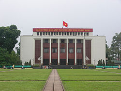
 Ba Dinh Hall | |
| Nickname: French Quarter (Khu phố Pháp) | |
| Country | |
| Province | Hanoi |
| Number of wards | 14 |
| Area | |
| • Total | 9.244 km2 (3.569 sq mi) |
| Population (2009) | |
| • Total | 225,910 |
| Time zone | UTC+7 (ICT) |
| Website | Official website Template:Vi |
Ba Đình is an urban district of Hanoi, the capital city of Vietnam. Ba Dinh is the political center of Vietnam. Most of the government offices and embassies are located here. It was formally called the "French Quarter" (Khu phố Pháp), a name that is still used in travel literature.[1]
Location
It's surround at the north by Tây Hồ, to the east by Red River, to the south by Đống Đa, to the southeast by Hoàn Kiếm, to the west by Cầu Giấy.
Administrative divisions
The district contains 14 wards (phường)

References
- ^ "French Quarter in Hanoi to be preserved", VietnamPlus, 18 Nov. 2010.
Downs, Tom, Hanoi & Halong Bay encounter (2007), p. 66. " "Much of the appeal of Hanoi's French Quarter is in its colonial architecture".
21°02′12″N 105°50′10″E / 21.03667°N 105.83611°E

