Bay Springs Lake: Difference between revisions
Appearance
Content deleted Content added
Magioladitis (talk | contribs) m clean up using AWB (11427) |
Rescuing 1 sources and tagging 0 as dead. #IABot (v1.2.6) |
||
| Line 28: | Line 28: | ||
== External links == |
== External links == |
||
*{{PDF|[http://tenntom.sam.usace.army.mil/pdf/rec/lakemaps/baysprings.pdf map of Bay Springs Lake]|389 [[Kibibyte|KiB]]<!-- pdf, 398722 bytes -->}} from [[United States Army Corps of Engineers|USACE]]. |
*{{PDF|[https://web.archive.org/web/20060922173550/http://tenntom.sam.usace.army.mil/pdf/rec/lakemaps/baysprings.pdf map of Bay Springs Lake]|389 [[Kibibyte|KiB]]<!-- pdf, 398722 bytes -->}} from [[United States Army Corps of Engineers|USACE]]. |
||
[[Category:Protected areas of Prentiss County, Mississippi]] |
[[Category:Protected areas of Prentiss County, Mississippi]] |
||
Revision as of 03:05, 29 October 2016
| Bay Springs Lake | |
|---|---|
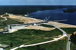
 Jamie Whitten Lock and Dam | |
| Location | Tishomingo / Prentiss counties, Mississippi |
| Coordinates | 34°34′16″N 88°18′58″W / 34.5710°N 88.3160°W |
| Type | reservoir |
| Primary inflows | Tennessee-Tombigbee Waterway |
| Primary outflows | Tennessee-Tombigbee Waterway |
| Basin countries | United States |
| Max. length | 9 mi (14 km) |
Bay Springs Lake is a reservoir on the Tennessee-Tombigbee Waterway in the U.S. state of Mississippi. It is impounded by the Jamie Whitten Lock and Dam. The lake is approximately nine miles long, between waterway mile markers 412 at the dam, and 421 near the entrance to the divide cut.
External links
- Template:PDF from USACE.
