Guayaramerín Municipality: Difference between revisions
Appearance
Content deleted Content added
JJMC89 bot (talk | contribs) Migrate {{Infobox settlement}} coordinates parameters to {{Coord}}, see Wikipedia:Coordinates in infoboxes |
Rescuing 1 sources and tagging 0 as dead. #IABot (v1.3beta3) |
||
| Line 126: | Line 126: | ||
== References == |
== References == |
||
{{Reflist}} |
{{Reflist}} |
||
* [http://www.ine.gov.bo/ Instituto Nacional de Estadistica de Bolivia] |
* [https://web.archive.org/web/20091113141644/http://www.ine.gov.bo/ Instituto Nacional de Estadistica de Bolivia] |
||
{{Beni-geo-stub}} |
{{Beni-geo-stub}} |
||
Revision as of 00:14, 26 March 2017
You can help expand this article with text translated from the corresponding article in German. (August 2011) Click [show] for important translation instructions.
|
Guayaramerín Municipality | |
|---|---|
Municipality | |
| Coordinates: 11°10′S 65°30′W / 11.167°S 65.500°W | |
| Country | |
| Department | Beni Department |
| Population (2001) | |
| • Total | 40,444 |
| Time zone | UTC-4 (-4) |
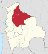
Guayaramerín Municipality is a municipality of the Beni Department in Bolivia.


