
Letterklip: Difference between revisions
Content deleted Content added
move coord into infobox |
Rescuing 3 sources and tagging 0 as dead. #IABot (v1.3.1.1) |
||
| Line 33: | Line 33: | ||
}} |
}} |
||
{{Campaignbox Second Boer War}} |
{{Campaignbox Second Boer War}} |
||
The '''Letterklip''', [[Afrikaans]] for "lettered rock", is a [[provincial heritage site (South Africa)|provincial heritage site]] in [[Namaqualand]] in the [[Northern Cape]] province of [[South Africa]]. The unique rock formation was fortified by dry stone walling; it was occupied from 1901 to 1902 by British forces during the [[Anglo-Boer War]]. Various regimental badges and officers' names are engraved in the rockface.<ref>http://196.35.231.29/sahra/default.aspx South African Heritage Resource Agency database</ref> |
The '''Letterklip''', [[Afrikaans]] for "lettered rock", is a [[provincial heritage site (South Africa)|provincial heritage site]] in [[Namaqualand]] in the [[Northern Cape]] province of [[South Africa]]. The unique rock formation was fortified by dry stone walling; it was occupied from 1901 to 1902 by British forces during the [[Anglo-Boer War]]. Various regimental badges and officers' names are engraved in the rockface.<ref>{{cite web|url=http://196.35.231.29/sahra/default.aspx |title=Archived copy |accessdate=2008-12-31 |deadurl=yes |archiveurl=https://web.archive.org/web/20081231164928/http://196.35.231.29/sahra/default.aspx |archivedate=2008-12-31 |df= }} South African Heritage Resource Agency database</ref> |
||
==History== |
==History== |
||
| Line 60: | Line 60: | ||
==References== |
==References== |
||
{{Reflist}} |
{{Reflist}} |
||
* [http://196.35.231.29/sahra/default.aspx South African Heritage Resource Agency database] |
* [https://web.archive.org/web/20081231164928/http://196.35.231.29/sahra/default.aspx South African Heritage Resource Agency database] |
||
Revision as of 17:31, 14 May 2017
| Letterklip | |
|---|---|
"Lettered rock" | |
| Garies, South Africa | |
| Coordinates | 30°33′20″S 17°58′33″E / 30.55556°S 17.97583°E |
| Type | Natural rock formation, Dry Wall construction. |
| Site information | |
| Controlled by | |
| Open to the public | Yes |
| Condition | Intact |
| Site history | |
| Built | 1901 |
| Materials | Local stone. |
| Events | Second Boer War |
| Garrison information | |
| Garrison | British Forces |
The Letterklip, Afrikaans for "lettered rock", is a provincial heritage site in Namaqualand in the Northern Cape province of South Africa. The unique rock formation was fortified by dry stone walling; it was occupied from 1901 to 1902 by British forces during the Anglo-Boer War. Various regimental badges and officers' names are engraved in the rockface.[1]
History
In 1980, it was described in the Government Gazette of South Africa:
This unique rock formation was fortified and occupied from 1901 to 1902 by the British forces during the Anglo-Boer War. Various regimental badges and officers' names are engraved in the rockface.
-
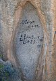 Engravings on the rocks

See also
- List of Castles and Fortifications in South Africa
- Military history of South Africa
- List of castles in Africa
- History of South Africa
- List of castles
- List of forts
- Second Boer War
- List of heritage sites in Northern Cape
References
- ^ "Archived copy". Archived from the original on 2008-12-31. Retrieved 2008-12-31.
{{cite web}}: Unknown parameter|deadurl=ignored (|url-status=suggested) (help)CS1 maint: archived copy as title (link) South African Heritage Resource Agency database