Čakov (Benešov District): Difference between revisions
Appearance
Content deleted Content added
update coords format in infobox |
No edit summary |
||
| Line 1: | Line 1: | ||
{{Unreferenced|date=September 2014}} |
{{Unreferenced|date=September 2014}} |
||
{{Infobox |
{{Infobox settlement |
||
<!--See |
<!-- See Template:Infobox settlement for additional fields and descriptions --> |
||
<!-- Basic info ----------------> |
<!-- Basic info ----------------> |
||
|name =Čakov |
|name =Čakov |
||
Revision as of 19:54, 16 November 2017
Čakov | |
|---|---|
Municipality and village | |
 | |
| Country | |
| Region | Central Bohemian Region |
| District | Benešov District |
| Area | |
| • Total | 2.04 sq mi (5.28 km2) |
| Elevation | 1,490 ft (454 m) |
| Population (2013) | |
| • Total | 126 |
| Time zone | UTC+1 (CET) |
| • Summer (DST) | UTC+2 (CEST) |
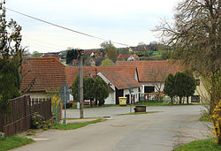
Čakov is a municipality and village in Benešov District in the Central Bohemian Region of the Czech Republic. It is located 12 kilometres (7.5 mi) northeast of Benešov and 40 kilometres (25 mi) southeast of Prague.
The municipality covers an area of 5.28 square kilometres (2.04 sq mi), and as of 2013 it had a population of 126. The first written mention of the village dates from the year 1226.
Wikimedia Commons has media related to Čakov (Benešov District).
49°49′07″N 14°50′02″E / 49.8186°N 14.8339°E
Wikimedia Commons has media related to Čakov (Benešov District).
