
North Stainley with Sleningford: Difference between revisions
Content deleted Content added
Rescuing 1 sources and tagging 0 as dead. #IABot (v1.6.4) |
Clanksided (talk | contribs) No edit summary |
||
| Line 53: | Line 53: | ||
| area_code = |
| area_code = |
||
| iso_code = |
| iso_code = |
||
| website = |
| website = {{URL|www.northstainleyparishcouncil.btck.co.uk}} |
||
| footnotes = |
| footnotes = |
||
}} |
}} |
||
Revision as of 06:26, 28 March 2018
North Stainley with Sleningford | |
|---|---|
Civil parish | |
| Coordinates: 54°11′N 1°34′W / 54.19°N 1.56°W | |
| Country | England |
| Primary council | Harrogate |
| County | North Yorkshire |
| Region | Yorkshire and the Humber |
| Status | Parish |
| Government | |
| • Type | Parish Council |
| • UK Parliament | Skipton and Ripon |
| • EU Parliament | Yorkshire and the Humber |
| Population ((Including Eavestone. 2011)[1]) | |
| • Total | 737 |
| Website | www |
North Stainley with Sleningford is a civil parish in Harrogate district, North Yorkshire, England. The principal settlement and only village in the parish is North Stainley. The parish also includes the small settlements of Sleningford, North Lees and Sutton Grange. The Lightwater Valley theme park is also in the parish.
The parish is bounded on the north and east by the River Ure, and on the south by the city of Ripon.
North Stainley with Sleningford was historically a township in the ancient parish of Ripon in the West Riding of Yorkshire.[2] It became a civil parish in 1866.[3] It was transferred to North Yorkshire in 1974. In 1988 the parish absorbed the small civil parish of Sutton Grange.[4]
-
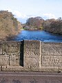 The bridge over the Ure at West Tanfield bears an inscription to mark the boundary between the West and North Ridings of Yorkshire.
 -
 Sleningford Water Mill on the banks of the River Ure downstream from West Tanfield
_-_geograph.org.uk_-_1580111.jpg)

References
Wikimedia Commons has media related to North Stainley with Sleningford.
- ^ "Civil Parish population 2011". Neighbourhood Statistics. Office for National Statistics. Retrieved 3 August 2015.
- ^ "Places in the Parish of Ripon in 1822". GENUKI. 2014-02-09. Retrieved 2014-06-21.
- ^ "Vision of Britain website". Visionofbritain.org.uk. Retrieved 2014-06-21.
- ^ Harrogate (Parishes) Order 1988, "Bulletin of changes of Local Authorities status, names and areas" (PDF). Department of the Environment. 1987–88. p. 6. Archived from the original (PDF) on 3 December 2013. Retrieved 26 June 2013.
{{cite web}}: Unknown parameter|deadurl=ignored (|url-status=suggested) (help)