
Cable Bay Trail: Difference between revisions
Content deleted Content added
No edit summary |
No edit summary |
||
| Line 36: | Line 36: | ||
=== References === |
=== References === |
||
<references> |
|||
[[Category:Hiking trails in British Columbia]] |
[[Category:Hiking trails in British Columbia]] |
||
Revision as of 22:55, 15 November 2018
49°07′35″N 123°49′40″W / 49.1264°N 123.8277°W
| Cable Bay Trail | |
|---|---|
 Trail through the upper forest | |
| Length | 2 km (1.2 mi) |
| Location | Cedar, British Columbia |
| Trailheads | Nicola Road |
| Use | Hiking |
| Elevation gain/loss | 90m |
| Highest point | 90m |
| Lowest point | 0m |
| Difficulty | Easy |
| Sights | Beaches, old growth forest, birds and marine mammals |
| Hazards | Moderately steep section of trail and slippery rocks |
The Cable Bay Trail is a 2km hiking trail located in Cedar on central Vancouver Island, British Columbia, Canada.
The trail
The trail is accessed via Nicola Road in Cedar. The trail winds its way down to the oceanfront overlooking Gabriola Island through a coastal Douglas Fir forest. Following the Cable Bay Trail leads down Joan Point Park, a 23 acre waterfront park which provides a great vantage point overlooking Dodds Narrows. The trail also passes through Garry Oak ecosystem, and features in genetic studies of endangered Garry Oak populations.[1]
-
 The Cable Bay Trail leading down through the forest
 -
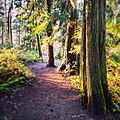 The trail leading through the woods

External links
- City of Nanaimo Parks Information for the Cable Bay Trail
- Trail Peak Information on the Cable Bay Trail
References
- ^ E., Catherall, Erin; K., Janes, Jasmine; A., Josefsson, Caroline; C., Gorrell, Jamieson (2018). "[Pre-print] Spatial and temporal assessments of genetic structure in an endangered Garry oak ecosystem on Vancouver Island". doi:10.25316/ir-409. ISSN 1916-2790.
{{cite journal}}: Cite journal requires|journal=(help)CS1 maint: multiple names: authors list (link)