
Manston, Leeds: Difference between revisions
KolbertBot (talk | contribs) m Bot: HTTP→HTTPS (v485) |
No edit summary Tags: Mobile edit Mobile web edit |
||
| Line 17: | Line 17: | ||
|static_image_caption = Manston Park |
|static_image_caption = Manston Park |
||
}} |
}} |
||
'''Manston''' is a suburb and former village to the east of [[Cross Gates, Leeds|Cross Gates]], [[Leeds]], [[England]], situated {{convert|4|mi|km|0}} east of [[Leeds city centre]]. |
|||
'''Manston''' is an area to the east of [[Cross Gates, Leeds|Cross Gates]], [[Leeds]], [[England]], that lies {{convert|4|mi|km|0}} to the east of [[Leeds city centre]]. It is East of the Ring Road, North of Austhorpe Road and South of Barwick Road.<ref name=Leedsgov>[http://www.leeds.gov.uk/docs/East%20leeds%20extension%20indicative%20plan.pdf www.leeds.gov.uk] East Leeds Extension Indicative Plan</ref><ref name=AtoZ> ''AZ Leeds and Bradford Street Atlas'', Geographer's A-Z Map Company, London, 1993</ref> The area falls within the Cross Gates and Whinmoor ward of Leeds Metropolitan Council. It is named after the former Manston estate of the [[Gascoigne baronets|Gascoigne family]].<ref name=Leodis>[http://www.leodis.net/display.aspx?resourceIdentifier=20031030_23878115 Leodis] Aerial View, Manston, showing Royal Ordnance Factory Barnbow</ref> Many streets in the area are named after Manston, such as Manston Crescent and Manston Grove. Manston Grove serves as a through-route from the north of Manston and places beyond, including Seacroft, to [[Crossgates Shopping Centre|Cross Gates Shopping Centre]] and [[Cross Gates railway station|Cross Gates Railway Station]]. |
|||
Situated in the [[Cross Gates and Whinmoor (ward)|Cross Gates & Whinmoor]] ward of [[Leeds City Council]] and [[Leeds East (UK Parliament constituency)|Leeds East]] parliamentary constituency, the area is east of the [[Leeds Outer Ring Road|A6120 Outer Ring Road]], and sits between Barwick Road to the north and Austhorpe Road to the south.<ref name=Leedsgov>[http://www.leeds.gov.uk/docs/East%20leeds%20extension%20indicative%20plan.pdf www.leeds.gov.uk] East Leeds Extension Indicative Plan</ref><ref name=AtoZ> ''AZ Leeds and Bradford Street Atlas'', Geographer's A-Z Map Company, London, 1993</ref> |
|||
It contains [[Barnbow]], the site of a munitions factory in both World Wars, and now a scheduled monument.<ref name=BBC>[https://www.bbc.co.uk/news/uk-england-leeds-37586686 BBC News 10 October 2016] Barnbow munitions blast factory site given heritage status</ref> It has its own park, Manston Park. Manston Park is a well-used local park on Austhorpe Road, and contains a memorial to those killed in an explosion at Barnbow munitions factory. The area had a pub named after it, the Manston hotel, which is now known as The Barnbow, next to the park. It has a Parish Church, St James the Great,<ref name=StJames>[http://www.stjamesmanston.church/ /www.stjamesmanston.church]</ref> and is also home to three primary schools, Manston Primary, Manston St James Primary Academy and St Theresa's Catholic Primary. |
|||
It is named after the former Manston Hall on Manston Lane and the surrounding estate, owned by the [[Gascoigne baronets|Gascoigne family]].<ref name=Leodis>[http://www.leodis.net/display.aspx?resourceIdentifier=20031030_23878115 Leodis] Aerial View, Manston, showing Royal Ordnance Factory Barnbow</ref> Many streets in the area are named after the estate, including Manston Crescent and Manston Grove. |
|||
Manston is also home to Manston Park, a [[urban park|public park]], and a pub named after the area, The Barnbow (formerly The Manston Hotel) to the east of the park. |
|||
The local Parish Church and a local [[primary school]], Manston St James Primary Academy, are named after St [[James the Great]].<ref name=StJames>[http://www.stjamesmanston.church/ /www.stjamesmanston.church]</ref> There are also two other primary schools in Manston Primary and St Theresa's Catholic Primary Schools. |
|||
The area also contains [[Barnbow]], the site of a munitions factory in both [[First World War]], the [[interwar period]] and [[Second World War]]. Now a scheduled monument, a memorial to those killed in a 5 December 1916 explosion at the munitions factory is situated in Manston Park.<ref name=BBC>[https://www.bbc.co.uk/news/uk-england-leeds-37586686 BBC News 10 October 2016] Barnbow munitions blast factory site given heritage status</ref> |
|||
<gallery> |
<gallery> |
||
File:St James The Great Church Of England Church, Church Lane, Leeds (geograph 5036081).jpg|St James Church |
File:St James The Great Church Of England Church, Church Lane, Leeds (geograph 5036081).jpg|St James Church |
||
Revision as of 13:38, 8 October 2019
| Manston | |
|---|---|
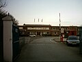
 Manston Park | |
 Manston Location within West Yorkshire | |
| Metropolitan borough | |
| Metropolitan county | |
| Region | |
| Country | England |
| Sovereign state | United Kingdom |
| Post town | Leeds |
| Postcode district | LS15 |
| Dialling code | 0113 |
| Police | West Yorkshire |
| Fire | West Yorkshire |
| Ambulance | Yorkshire |
| UK Parliament | |
Manston is a suburb and former village to the east of Cross Gates, Leeds, England, situated 4 miles (6 km) east of Leeds city centre.
Situated in the Cross Gates & Whinmoor ward of Leeds City Council and Leeds East parliamentary constituency, the area is east of the A6120 Outer Ring Road, and sits between Barwick Road to the north and Austhorpe Road to the south.[1][2]
It is named after the former Manston Hall on Manston Lane and the surrounding estate, owned by the Gascoigne family.[3] Many streets in the area are named after the estate, including Manston Crescent and Manston Grove.
Manston is also home to Manston Park, a public park, and a pub named after the area, The Barnbow (formerly The Manston Hotel) to the east of the park.
The local Parish Church and a local primary school, Manston St James Primary Academy, are named after St James the Great.[4] There are also two other primary schools in Manston Primary and St Theresa's Catholic Primary Schools.
The area also contains Barnbow, the site of a munitions factory in both First World War, the interwar period and Second World War. Now a scheduled monument, a memorial to those killed in a 5 December 1916 explosion at the munitions factory is situated in Manston Park.[5]
-
 St James Church
 -
 The Vickers works, formerly Barnbow Royal Ordnance Factory
 -
 The old Optare bus factory in Manston
 -
 The Manston public house, now called The Barnbow
.jpg)


References
- ^ www.leeds.gov.uk East Leeds Extension Indicative Plan
- ^ AZ Leeds and Bradford Street Atlas, Geographer's A-Z Map Company, London, 1993
- ^ Leodis Aerial View, Manston, showing Royal Ordnance Factory Barnbow
- ^ /www.stjamesmanston.church
- ^ BBC News 10 October 2016 Barnbow munitions blast factory site given heritage status
External links
- The Ancient Parish of Whitkirk at GENUKI: Manston was in this parish
This West Yorkshire location article is a stub. You can help Wikipedia by expanding it. |