
Schiller-Zucchius Basin: Difference between revisions
m Open access bot: doi added to citation with #oabot. |
m Fixed typo of the diameter that stated 335 km, although the citation states 325 km. |
||
| Line 3: | Line 3: | ||
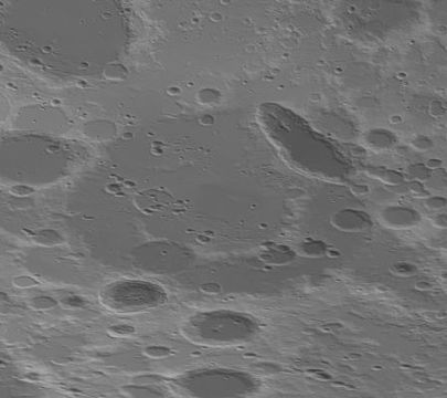
| caption = [[Lunar Orbiter 4]] image showing most of the basin, highlighted in red |
| caption = [[Lunar Orbiter 4]] image showing most of the basin, highlighted in red |
||
| coordinates = {{coord|56.0|S|045.0|W|globe:moon_type:landmark|display=inline,title}} |
| coordinates = {{coord|56.0|S|045.0|W|globe:moon_type:landmark|display=inline,title}} |
||
| diameter = |
| diameter = 325 km<ref>The geologic history of the Moon, 1987, Wilhelms, Don E.; with sections by McCauley, John F.; Trask, Newell J. USGS Professional Paper: 1348. ([https://pubs.er.usgs.gov/publication/pp1348 online])</ref> |
||
| eponym = [[Schiller (crater)|Schiller]] and [[Zucchius (crater)|Zucchius]] craters |
| eponym = [[Schiller (crater)|Schiller]] and [[Zucchius (crater)|Zucchius]] craters |
||
}} |
}} |
||
Revision as of 17:32, 3 May 2020
 Lunar Orbiter 4 image showing most of the basin, highlighted in red | |
| Coordinates | 56°00′S 45°00′W / 56.0°S 045.0°W |
|---|---|
| Diameter | 325 km[1] |
| Eponym | Schiller and Zucchius craters |
The Schiller-Zucchius Basin is a Pre-Nectarian impact basin on the near side of the moon.[2] It is named after the elongated crater Schiller at the northeast margin and fresh crater Zucchius near the southwest margin. This basin has received the unofficial designation 'Schiller Annular Plain' among lunar observers.
The basin has a clear but eroded outer rim and a partial inner ring.
Also at the center is a mass concentration (mascon), or gravitational high. The mascon was first identified by Doppler tracking of the Lunar Prospector spacecraft.[3]
Other craters within the basin include Segner and Weigel, as well as many satellite craters. Due south of the basin is Bettinus, to the northwest of the basin are Phocylides and Nasmyth, to the north is Nöggerath, and to the east is Rost.
-
 Topographic map
 -
 Gravity map based on GRAIL
 -
 Earth-based image showing the basin with labeled features


References
- ^ The geologic history of the Moon, 1987, Wilhelms, Don E.; with sections by McCauley, John F.; Trask, Newell J. USGS Professional Paper: 1348. (online)
- ^ Impact Basin Database at Wayback Machine
- ^ A. S. Konopliv; A. B. Binder; L. L. Hood; A. B. Kucinskas; W. L. Sjogren; J. G. Williams (1998). "Improved Gravity Field of the Moon from Lunar Prospector". Science. 281 (5382): 1476–1480. doi:10.1126/science.281.5382.1476. PMID 9727968.
{{cite journal}}: Unknown parameter|last-author-amp=ignored (|name-list-style=suggested) (help)