
Bad Brambach: Difference between revisions
Content deleted Content added
mNo edit summary |
new mayor |
||
| Line 19: | Line 19: | ||
|Straße = Adorfer Straße 1 |
|Straße = Adorfer Straße 1 |
||
|website = [http://www.badbrambach.de/ www.badbrambach.de] |
|website = [http://www.badbrambach.de/ www.badbrambach.de] |
||
|mayor = |
|mayor = Maik Schüller [[Independent]] |
||
}} |
}} |
||
Revision as of 15:34, 19 May 2020
Bad Brambach | |
|---|---|
 In the spa park | |
 Coat of arms | |
Location of Bad Brambach within Vogtlandkreis district 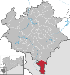 | |
 Bad Brambach  Bad Brambach | |
| Coordinates: 50°13′N 12°19′E / 50.217°N 12.317°E | |
| Country | Germany |
| State | Saxony |
| District | Vogtlandkreis |
| Subdivisions | 13 |
| Government | |
| • Mayor | Maik Schüller Independent |
| Area | |
| • Total | 43.92 km2 (16.96 sq mi) |
| Elevation | 604 m (1,982 ft) |
| Population (2022-12-31)[1] | |
| • Total | 1,712 |
| • Density | 39/km2 (100/sq mi) |
| Time zone | UTC+01:00 (CET) |
| • Summer (DST) | UTC+02:00 (CEST) |
| Postal codes | 08648 |
| Dialling codes | 03 74 38 |
| Vehicle registration | V, AE, OVL, PL, RC |
| Website | www.badbrambach.de |
Bad Brambach is a municipality in the Vogtlandkreis district, in Saxony, Germany. It is the southernmost municipality in Saxony and also in what was formerly East Germany. It is a spa town with radon baths.
Demographics
Historical population (31 December):
|
|
|
|
|
- Data source: Digital historical files of Saxony (until 1964), from 1998: Statistical Office of Saxony
References
- ^ "Einwohnerzahlen nach Gemeinden als Excel-Arbeitsmappe" (XLS) (in German). Statistisches Landesamt des Freistaates Sachsen. 2024.
Wikimedia Commons has media related to Bad Brambach.
| International | |
|---|---|
| National | |
This Vogtlandkreis location article is a stub. You can help Wikipedia by expanding it. |