
Search results
The page '"cassiar"' does not exist; did you mean "cassiar"? If not, you can create a draft and submit it for review or request that a redirect be created, but consider checking the search results below to see whether the topic is already covered.
- Cassiar Country, also referred to simply as the Cassiar, is a historical geographic region of the Canadian province of British Columbia. The Cassiar is...8 KB (526 words) - 01:46, 10 March 2023
 The Cassiar Mountains (French: Chaîne des Cassiars) are the most northerly group of the Northern Interior Mountains in the Canadian province of British...3 KB (213 words) - 06:44, 11 November 2021
 The Stewart–Cassiar Highway, also known as the Dease Lake Highway and the Stikine Highway as well as the Thornhill –Kitimat Highway from Kitimat to Thornhill...11 KB (826 words) - 20:33, 22 April 2024
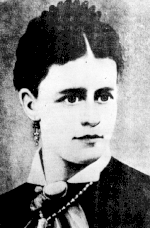 Nellie Cashman (redirect from Angel of the Cassiar)and Yukon. Cashman led a rescue party to miners to the Cassiar Country gold mine in the Cassiar Mountains of British Columbia. In Tombstone, Arizona, Cashman...29 KB (3,144 words) - 05:58, 6 April 2024
- Atsutla Range (category Cassiar Country)lies south of the Yukon border in between Teslin Lake and the Stewart-Cassiar Highway, roughly 120 km (75 mi) north-northeast of Dease Lake. Atsutla...1 KB (68 words) - 05:14, 2 October 2023
- Thudaka Peak (category Cassiar Land District)Thudaka Peak is the highest mountain of the Thudaka Range of the Cassiar Mountains in the Northern Interior of British Columbia, Canada, located between...2 KB (86 words) - 23:35, 10 November 2021
- Stikine Ranges (category Cassiar Mountains)the Cassiar Mountains and among the least explored and most undeveloped parts of the province. The Sifton Ranges, which are also part of the Cassiar Mountains...2 KB (249 words) - 03:27, 29 December 2022
- Level Mountain Range (category Cassiar Country)-131.43722 Geography Country Canada Province British Columbia District Cassiar Land District Range coordinates 58°23′26″N 131°24′06″W / 58.39056°N 131...2 KB (138 words) - 18:43, 25 June 2022
- Horseranch Range (category Cassiar Mountains)Deadwood Lake. Part of the Dease Plateau of either the Yukon Plateau or Cassiar Mountains system, it contains no glaciers and lies completely above tree...2 KB (80 words) - 13:27, 16 March 2021
- Meehaz Mountain (category Cassiar Country)Meehaz Mountain is a mountain in the Cassiar Country of the Northern Interior of British Columbia, Canada, located on the north side of the headwaters...2 KB (111 words) - 03:37, 22 July 2024
- Kechika Ranges (category Cassiar Mountains)The Kechika Ranges are a subrange of the Cassiar Mountains subdivision of the Interior Mountains in far northern British Columbia, Canada, lying west...712 bytes (68 words) - 18:37, 4 January 2020
- Toozaza Peak (category Cassiar Country)Toozaza Peak is a tuya in the Stikine Ranges of the Cassiar Mountains in northern British Columbia, Canada, located in the Iverson Creek. Toozaza Peak...3 KB (175 words) - 18:09, 19 July 2024
- Shelagyote Peak (category Cassiar Land District)95500; -127.20611 Geography Location British Columbia, Canada District Cassiar Land District Parent range Sicintine Range Topo map NTS 93M14 Shelagyote...1 KB (62 words) - 06:23, 5 October 2021
- The Cassiar Land District is a cadastral survey subdivision of the province of British Columbia, Canada, created with rest of those on Mainland British...3 KB (394 words) - 14:22, 22 July 2024
- Nahlin Mountain (category Cassiar Country)85694; -132.08806 Geography Location British Columbia, Canada District Cassiar Land District Parent range Interior Mountains Topo map NTS 104K16 Teditua...1 KB (41 words) - 23:14, 25 August 2021
- Sifton Ranges (category Cassiar Mountains)Columbia, Canada. It has an area of 1823 km2 and is a subrange of the Cassiar Mountains which in turn form part of the Interior Mountains. Cormier Range...1 KB (64 words) - 14:59, 1 August 2023
- Shedin Peak (category Cassiar Land District)93917; -127.48000 Geography Location British Columbia, Canada District Cassiar Land District Parent range Atna Range Topo map NTS 93M14 Shelagyote Peak...2 KB (99 words) - 23:36, 10 November 2021
- Mount Thomlinson (category Cassiar Land District)54333; -127.48667 Geography Location British Columbia, Canada District Cassiar Land District Parent range Babine Range Topo map NTS 93M11 Gunanoot Lake...3 KB (121 words) - 02:08, 25 July 2023
- South Tuya (category Cassiar Country)20861; -130.50528 Geography Location British Columbia, Canada District Cassiar Land District Parent range Tuya Range Geology Age of rock Pleistocene Mountain...2 KB (105 words) - 19:01, 29 September 2023
 Tuya Range (category Cassiar Country)The Tuya Range is a mountain range in the Stikine Ranges of the Cassiar Mountains in the far north of the Canadian province of British Columbia, near...4 KB (404 words) - 03:37, 29 November 2023


- Cassiar Connector Cassiar Country Cassiar County Cassiar District Cassiar Gold Rush Cassiar Highway Cassiar Land District Cassiar Mountains Cassiar Ranges
- Alaska Summers IV. The Travels in Alaska River V. A Cruise in the Cassiar VI. The Cassiar Trail VII. Glenora Peak VIII. Exploration of the Travels in Alaska
- Highway 37, the Stewart-Cassiar Highway, also known as the Dease Lake Highway and the Stikine Highway, is a road mostly in northwestern British Columbia
- and reprinted in Travels in Alaska (1915), chapter 5, A Cruise in the Cassiar (First lines of the documentary film series "The National Parks: America's