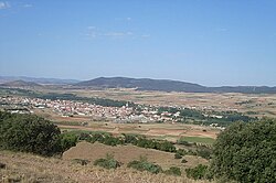
Calamocha
Appearance
Calamocha | |
|---|---|
 | |
| Coordinates: 40°55′2″N 1°18′0″W / 40.91722°N 1.30000°W | |
| Country | Spain |
| Autonomous community | Aragon |
| Province | Teruel |
| Comarca | Jiloca Comarca |
| Government | |
| • Mayor | Manuel Rando López (PSOE de Aragón) (2015–2019) |
| Area | |
| • Total | 316.63 km2 (122.25 sq mi) |
| Population (2018)[1] | |
| • Total | 4,319 |
| • Density | 14/km2 (35/sq mi) |
| Demonym | Calamochino |
| Time zone | UTC+1 (CET) |
| • Summer (DST) | UTC+2 (CEST) |
Calamocha is a town and municipality of Teruel province in the autonomous community of Aragon, Spain. In 2015 the municipality had a population of 4,417 inhabitants.
Calamocha is the administrative centre of the Aragonese comarca of Jiloca. On January 12, 2021, a minimum temperature of −21.3 °C (−6.3 °F) was registered in a close village called Fuentes Claras.[2]
Villages
As well as the town of Calamocha itself, the following villages and hamlets form part of the municipality:
- Collados
- Cuencabuena
- Cutanda
- Lechago
- Luco de Jiloca
- Navarrete del Río
- Nueros
- Olalla
- El Poyo del Cid
- Valverde
- Villarejo de los Olmos
References
- ^ Municipal Register of Spain 2018. National Statistics Institute.
- ^ "España sufre su día más gélido en los últimos 20 años, con ocho capitales a 10º bajo cero" [Spain suffers its coldest day in the last 20 years, with eight capitals at 10º below zero] (in Spanish). El País. 12 January 2021. Retrieved 12 January 2021.
External links
Wikimedia Commons has media related to Calamocha.


