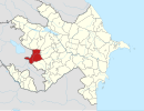
Nəbilər, Kalbajar
Appearance
40°06′N 46°13′E / 40.100°N 46.217°E
Nəbilər | |
|---|---|
| Coordinates: 40°06′07.3″N 46°13′20.8″E / 40.102028°N 46.222444°E | |
| Country | |
| District | Kalbajar |
| Elevation | 1,612 m (5,289 ft) |
| Time zone | UTC+4 (AZT) |
| • Summer (DST) | UTC+5 (AZT) |
Nəbilər (Nabilar, formerly known as Quş yuvası or Quşyuvası[a][1]) is a village in the Kalbajar District of Azerbaijan.[2]
History
The village was occupied by Armenian forces during the First Nagorno-Karabakh war and administrated as part of the Shahumyan Province of the self-proclaimed Republic of Artsakh. After the 2020 Nagorno-Karabakh war, the village was returned to Azerbaijan per the 2020 Nagorno-Karabakh ceasefire agreement.
References
- ^ anglicized as Gushyuvasy
- ^ "KƏLBƏCƏR RAYONUNUN BƏZİ TOPONİMLƏRİNİN TARİXİ-COĞRAFİ MƏNŞƏYİ HAQQINDA". yerveinsan.az (in Azerbaijani). Yer və İnsan. 22 May 2019. Retrieved 5 February 2021.
- ^ Azərbaycan Respublikasının Dövlət Statistika Komitəsi (2019). "İnzibati ərazi bölgüsü təsnifatı" (PDF) (in Azerbaijani). stat.gov.az. Archived from the original (PDF) on 2020-04-16. Retrieved 2021-02-03.


