Ornain
Appearance
| Ornain | |
|---|---|
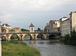
 Ornain flowing through Bar-le-Duc | |
 | |
| Location | |
| Country | France |
| Physical characteristics | |
| Mouth | |
• location | Saulx |
• coordinates | 48°46′7″N 4°48′15″E / 48.76861°N 4.80417°E |
| Length | 116 km (72 mi) |
| Basin features | |
| Progression | Saulx→ Marne→ Seine→ English Channel |
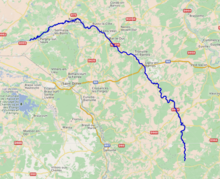
The Ornain (French pronunciation: [ɔʁnɛ̃]) is a 116 km long river in northeastern France, right tributary of the Saulx (Seine basin).[1] It is formed near the village Gondrecourt-le-Château by the confluence of the small rivers Ognon and Maldite. It flows generally northwest. Its course crosses the following départements and towns:
The Ornain flows into the Saulx in Pargny-sur-Saulx. The part of the Marne-Rhine Canal between Demange-aux-Eaux and Sermaize-les-Bains runs parallel to the Ornain.
References
Wikimedia Commons has media related to Ornain.
