New Guinea Community Site
New Guinea Community Site | |
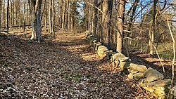
 Freedonia Lane in 2022 | |
| Location | Hyde Park; Dutchess County, New York |
|---|---|
| Nearest city | Poughkeepsie, NY |
| Coordinates | 41°47′17.88″N 73°55′36.84″W / 41.7883000°N 73.9269000°W |
| Area | 45 acres (18 ha) |
| Significant dates | |
| Added to NRHP | 2018 |
| Designated NRHP | 2018 |
The New Guinea Community Site is a former free Black community that is on the National Register of Historic Places, located in the Town of Hyde Park, New York. It emerged in the decades leading up to the Civil War, and dissipated quickly after the war ended.
Description
[edit]The New Guinea Community Site was listed on the National Register of Historic Places in 2018.[1] It was a transient free Black community and was typical of such communities in that it emerged in the decades prior to the Civil War, but dissipated after the war’s conclusion and the national abolition of slavery.[2] [3]

Interviews with former residents conducted by the local historian, Edward Braman, in the late 19th century.[4] offer first person testimony.
There were several incentives to form such a community. Self emancipated enslaved persons from the south could either temporarily, or permanently, live in the community without much notice. Free persons of color were always at risk of being kidnapped and illegally sold into slavery in the south, and a proximity of community helped with a collective security. At a time when New York State had property requirements for African Americans to vote, the New Guinea community offered a chance at property ownership.[5] [6]
Primus Martin was another leader in the settlement of New Guinea. His home site is an archaeological site in Hyde Park. Ceramic fragments found at the site indicate that Martin had communal dining and tea drinking at his home, suggesting that he was well established socially and possibly politically in the community.[7] In the 1860s, John Hackett bought land in the area of "Guinea" and built the Crum Elbow Farm. The community gradually dissolved.[8][9][10]
The area was home to free blacks that owned small farms and who worked for "elite' families along the Hudson river. The area where Primus and Elizabeth Martin stayed was the first area of the excavation project. They were community leaders of Guinea community.[11][12][13][14][15][16]
On December 22, 2017, Governor Andrew Cuomo announced 23 properties to be sites recommended by New York State Board of Historic Preservation for the state and national registry as a historic place including the New Guinea site located at East Market Street in Hyde Park.[17][18] A sign from the William G. Pomeroy Foundation[19] marks that portion of the site that is located within the Town of Hyde Park’s Hackett Hill park. Work by the Dutchess County Historical Society in 2022 revealed that the New Guinea extended immediately west of the Hackett Hill site.[20]
See also
[edit]- List of National Historic Landmarks in New York
- National Register of Historic Places listings in Dutchess County, New York
External links
[edit]References
[edit]- ^ National Register of Historic Places Weekly List.
- ^ Dutchess County Executive Department News.
- ^ Town of Hyde Park Historian.
- ^ Franklin D. Roosevelt Library & Museum Digital Archives.
- ^ The Quest for Black Voting Rights in New York State by Bennett Liebman, Albany Law School.
- ^ Dutchess County Historical Society.
- ^ "Guineatown in the Hudson Valley's Hyde Park : The Archaeology of Race in the Northeast - oi". oxfordindex.oup.com. doi:10.5744/florida/9780813060576.003.0003. Retrieved 2018-08-21.
- ^ "GC1JF0P Can you Hackett? (Traditional Cache) in New York, United States created by Yeahoh". geocaching.com. Retrieved 2018-08-21.
- ^ Rhinevault, C.; Rhinevault, T. (2011). Hidden History of the Mid-Hudson Valley: Stories from the Albany Post Road. Arcadia Publishing Incorporated. ISBN 9781625841001. Retrieved 2018-08-21.
- ^ "Re-evaluating the Place of Race in Historical Archaeology". Anthropology-News. Retrieved 2018-08-21.
- ^ "Hackett Hill Trail - Home Of Franklin D Roosevelt National Historic Site (U.S. National Park Service)". nps.gov. Retrieved 2018-08-21.
- ^ "Locals Dispute Over Guinea Community Artifacts". archaeologicalconservancy.org. Retrieved 2018-08-21.
- ^ "Hyde Park Site Recommended For Historic Registry". Northwest Dutchess Daily Voice. Retrieved 2018-08-21.
- ^ "African American History: A Past Rooted in the Hudson Valley - Hudson Valley Magazine - February 2017 - Poughkeepsie, NY". hvmag.com. Retrieved 2018-08-21.
- ^ "New York destroyed a village full of African-American landowners to create Central Park". CityMetric. Retrieved 2018-08-21.
- ^ "The Underground Railroad in the New York Hudson Valley « Fergus Bordewich: The Imperfect Union". fergusbordewich.com. Retrieved 2018-08-21.
- ^ "Governor Cuomo Announces 23 Properties Recommended to State and National Registers of Historic Places | Governor Andrew M. Cuomo". governor.ny.gov. Retrieved 2018-08-21.
- ^ "23 Properties Recommended to State, National Registers of Historic Places". Hudson Valley News Network. Retrieved 2018-08-21.
- ^ William G. Pomeroy Foundation.
- ^ Dutchess County Historical Society.


