Sena Nikhom
Sena Nikhom
เสนานิคม | |
|---|---|
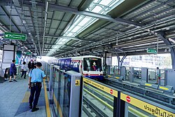
 BTS Skytrain approaching platform of Sena Nikhom BTS Station (Sena Nikhom side) | |
 Location in Chatuchak District | |
| Coordinates: 13°50′02.15″N 100°34′19.88″E / 13.8339306°N 100.5721889°E | |
| Country | |
| Province | Bangkok |
| Khet | Chatuchak |
| Named for | Sena Nikhom Junction |
| Area | |
| • Total | 2.826 km2 (1.091 sq mi) |
| Population (2022) | |
| • Total | 20,393 |
| • Density | 7,216.21/km2 (18,689.9/sq mi) |
| Time zone | UTC+7 (ICT) |
| Postal code | 10900 |
| TIS 1099 | 103002 |
Sena Nikhom (Template:Lang-th, pronounced [sěː.nāː ní(ʔ).kʰōm]) is a khwaeng (subdistrict) of Chatuchak district, Bangkok. It is a densely populated area and filled with many different types of residential houses.[2]
History
Its name Sena Nikhom comes from the same name intersection. It is a T junction of Phaholyothin Road (Highway 1) and Sena Nikhom 1 Road[a], better known as Soi Sena Nikhom.[2]
Sena Nikhom was declared a subdistrict in late 2003, along with four other subdistricts of Chatuchak.[3]
Geography
Sena Nikhom is considered an area on the northeastern side of the district.
Other subdistricts surround it include (from the north clockwise): Anusawari in Bang Khen district (Khlong Bang Bua is a boundary), Chorakhe Bua and Lat Phrao in Lat Phrao district (Khlong Bang Bua is a boundary), Chan Kasem in its district (Sena Nikhom 1 Road is a boundary), Lat Yao in its district (Phaholyothin Road is a boundary).[4]
Places
- Sena Nikhom BTS Station (share with Lat Yao)
- Bang Khen Market
- Paolo Kaset Hospital (formerly Mayo Hospital)
- Sripatum University
- RTA Chemical Department
Notes
- ^ While Sena Nikhom 2 Road is Soi Phaholyothin 34.
References
- ^ Administrative Strategy Division, Strategy and Evaluation Department, Bangkok Metropolitan Administration (2021). สถิติกรุงเทพมหานครประจำปี 2563 [Bangkok Statistics 2020] (PDF) (in Thai). Retrieved 27 November 2021.
{{cite web}}: CS1 maint: multiple names: authors list (link) - ^ a b "รู้จักย่านเสนานิคมแบบเจาะลึก" [Get to know Sena Nikhom neighbourhood in depth]. DDproperty (in Thai). 2019-03-26. Retrieved 2023-06-09.
- ^ "ประกาศกรุงเทพมหานคร เรื่อง เปลี่ยนแปลงพื้นที่แขวงลาดยาว และตั้งแขวงเสนานิคม แขวงจันทรเกษม แขวงจอมพล แขวงจตุจักร เขตจตุจักร" ["Bangkok Announcement on Change of Lat Yao Subdistrict area and set up Sena Nikhom Subdistrict Chan Kasem Subdistrict Chomphon Subdistrict Chatuchak Subdistrict, Chatuchak District"] (PDF). Ratchakitcha (in Thai). Archived from the original (PDF) on January 27, 2012. Retrieved 1 March 2022.
- ^ "แผนที่ดินไทยและธาตุอาหารพืช". r01.ldd.go.th (in Thai).
