
Bueyeros, New Mexico
Bueyeros, New Mexico | |
|---|---|
 Bueyeros  Bueyeros | |
| Coordinates: 35°58′46″N 103°41′14″W / 35.97944°N 103.68722°W | |
| Country | United States |
| State | New Mexico |
| County | Harding |
| Elevation | 4,547 ft (1,386 m) |
| Time zone | UTC-7 (Mountain (MST)) |
| • Summer (DST) | UTC-6 (MDT) |
| Area code | 505 |
| GNIS feature ID | 902189[1] |
Bueyeros is an unincorporated community in Harding County, New Mexico, United States.[1] The community is located on New Mexico State Road 102, 20.5 miles (33.0 km) northeast of Mosquero. Its name comes from a Spanish word meaning "ox drivers".[1]
The Bueyeros School, which is listed on the National Register of Historic Places, is located in Bueyeros.
References[edit]
Municipalities and communities of Harding County, New Mexico, United States | ||
|---|---|---|
| Villages | 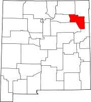 | |
| Unincorporated communities | ||
| Footnotes | ‡This populated place also has portions in an adjacent county or counties | |
This New Mexico state location article is a stub. You can help Wikipedia by expanding it. |