
Fishpond, Alabama
Fishpond, Alabama | |
|---|---|
 Fishpond, Alabama  Fishpond, Alabama | |
| Coordinates: 32°52′04″N 86°01′24″W / 32.86778°N 86.02333°W | |
| Country | United States |
| State | Alabama |
| County | Coosa |
| Elevation | 748 ft (228 m) |
| Time zone | UTC-6 (Central (CST)) |
| • Summer (DST) | UTC-5 (CDT) |
| Area code(s) | 256 & 938, 334 |
| GNIS feature ID | 156349[1] |
Fishpond is an unincorporated community in Coosa County, Alabama, United States.
References[edit]
Municipalities and communities of Coosa County, Alabama, United States | ||
|---|---|---|
| Towns | 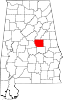 | |
| CDPs | ||
| Other unincorporated communities | ||
| Footnotes | ‡This populated place also has portions in an adjacent county or counties | |
This Coosa County, Alabama state location article is a stub. You can help Wikipedia by expanding it. |