
Southard, Oklahoma
Southard, Oklahoma | |
|---|---|
 Southard, Oklahoma | |
| Coordinates: 36°03′21″N 98°28′31″W / 36.05583°N 98.47528°W | |
| Country | United States |
| State | Oklahoma |
| County | Blaine |
| Elevation | 1,545 ft (471 m) |
| Time zone | UTC-6 (Central (CST)) |
| • Summer (DST) | UTC-5 (CDT) |
| ZIP code | 73770 |
| Area code | 580 |
| GNIS feature ID | 1098285[1] |
Southard is an unincorporated community in Blaine County, Oklahoma, United States.[1] Southard is located near the intersection of State Highway 51 and State Highway 51A, 6.3 miles (10.1 km) east of Canton. Southard has a post office with ZIP code 73770.[2][3]
References[edit]
- ^ a b c "Southard". Geographic Names Information System. United States Geological Survey, United States Department of the Interior.
- ^ United States Postal Service (2012). "USPS - Look Up a ZIP Code". Retrieved February 15, 2012.
- ^ "Postmaster Finder - Post Offices by ZIP Code". United States Postal Service. Retrieved April 18, 2014.
Municipalities and communities of Blaine County, Oklahoma, United States | ||
|---|---|---|
| Cities | 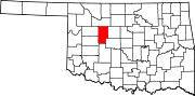 | |
| Towns | ||
| CDPs | ||
| Other community | ||
| Ghost towns | ||
| Footnotes | ‡This populated place also has portions in an adjacent county or counties | |
This Oklahoma state location article is a stub. You can help Wikipedia by expanding it. |