Dom Antônio Reis
Appearance
Dom Antônio Reis | |
|---|---|
 The bairro in District of Sede | |
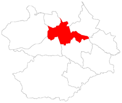
 District of Sede, in Santa Maria City, Rio Grande do Sul, Brazil | |
| Coordinates: 29°43′03.78″S 53°48′17.06″W / 29.7177167°S 53.8047389°W | |
| Country | Brazil |
| State | Rio Grande do Sul |
| Municipality/City | Santa Maria |
| District | District of Sede |
| Area | |
| • Total | 0.6270 km2 (0.2421 sq mi) |
| Population | |
| • Total | 1,984 |
| • Density | 3,200/km2 (8,200/sq mi) |
| Adjacent bairros | Cerrito, Lorenzi, Nossa Senhora Medianeira, Tomazetti, Uglione, Urlândia. |
| Website | Official site of Santa Maria |
Dom Antônio Reis[2] ("Dom Antônio Reis - Brazilian bishop") is a bairro in the District of Sede in the municipality of Santa Maria, in the Brazilian state of Rio Grande do Sul. It is located in south Santa Maria.
Villages
[edit]The bairro contains the villages of Dom Antônio Reis, Parque Residencial Dom Antonio Reis and Seminário São José.
References
[edit]- ^ "Population of the territories of Santa Maria" (in Portuguese). Brazilian Institute of Geography and Statistics.
- ^ "Municipal Law 0072 of 2009 that establishes the law of use and occupation of the soil, subdivision, urban perimeter and road system of the municipality of Santa Maria" (in Portuguese). Archived from the original on 2013-11-03.
