Bee, Virginia
Appearance
Bee, Virginia | |
|---|---|
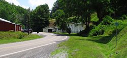
 Bee, Virginia, in 2014 | |
| Coordinates: 37°06′54″N 82°10′19″W / 37.11500°N 82.17194°W | |
| Country | United States |
| State | Virginia |
| County | Dickenson |
| Elevation | 1,444 ft (440 m) |
| Time zone | UTC-5 (Eastern (EST)) |
| • Summer (DST) | UTC-4 (EDT) |
| ZIP code | 24217 |
| Area code | 276 |
| GNIS feature ID | 1492538[1] |
Bee is an unincorporated community in Dickenson County, Virginia, United States. Bee is located along the Russell Fork and Virginia State Route 80 9.2 miles (14.8 km) southeast of Haysi. Bee had a post office until it closed on October 1, 2005; it still has its own ZIP code, 24217.[2][3]
Bee was named for Beatrice Owens.[4]
References
[edit]- ^ "Bee". Geographic Names Information System. United States Geological Survey, United States Department of the Interior.
- ^ United States Postal Service (2012). "USPS - Look Up a ZIP Code". Retrieved February 15, 2012.
- ^ "Postmaster Finder - Post Offices by ZIP Code". United States Postal Service. Archived from the original on April 28, 2019. Retrieved December 22, 2012.
- ^ Tennis, Joe (2004). Southwest Virginia Crossroads: An Almanac of Place Names and Places to See. The Overmountain Press. p. 10. ISBN 978-1-57072-256-1.


