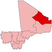
Anéfis
Anéfis | |
|---|---|
Commune and village | |
| Coordinates: 18°2′40″N 0°36′10″E / 18.04444°N 0.60278°E | |
| Country | |
| Region | Kidal Region |
| Cercle | Kidal Cercle |
| Area | |
• Total | 2,800 km2 (1,100 sq mi) |
| Population (2009)[2] | |
• Total | 5,087 |
| • Density | 1.8/km2 (4.7/sq mi) |
| Time zone | UTC+0 (GMT) |
Anéfis or Anefif is a Saharan village and commune in the Cercle of Kidal in the Kidal Region of north-eastern Mali.
Geography
[edit]Anefif is located on the Tessalit Trail. It lies 95 km (59 mi) southwest of Kidal on the route linking Kidal to Bourem and Gao. In 2009 the commune had a population of 5,087.[2]
There are multiple rocks and stones made from volcanic material.[3]
History
[edit]In 2013, the Malian Military attacked Tuareg rebels living in the village. The war was highly criticized by the military, and the press, who claimed that it was too invasive and violent.[4]
Climate
[edit]The commune has a Saharian climate and is too dry for rain-fed agriculture. The annual rainfall of around 150 mm occurs between late June and early September.[1]
Kel Adagh
[edit]There are many Kel Adagh in the area, along with multiple small clans.[5]
Notable people
[edit]- Abdullah Senussi - Head of Libyan Military Intelligence (born 1949).[6]
References
[edit]- ^ a b Programme de renforcement des capacités nationales pour une gestion stratégique du développement (PRECAGED): Schéma d'aménagement et de développement de la Commune Rurale Anefif (in French), République du Mali: Ministère de l'économie programme des nations unies et des finances, 2004, archived from the original on 2012-03-17.
- ^ a b Resultats Provisoires RGPH 2009 (Région de Kidal) (PDF), République de Mali: Institut National de la Statistique, archived from the original (PDF) on 2011-07-22.
- ^ Bertrand, J. M.; Bertrand-Sarfati, J.; Bessoles, B. (2013-10-22). Afrique de l'Ouest: Introduction Géologique et Termes Stratigraphiques (in French). Elsevier. ISBN 978-1-4831-3826-8.
- ^ Ahmed, Baba (5 June 2013). "Malian army takes Anefis, 1st territorial gain". The San Diego Union Tribune. Retrieved 26 July 2020.
- ^ Badi, Dida (2001-12-31). "Une expérience de recherche sur un terrain saharien : l'Adagh des Ifoughas". Insaniyat / إنسانيات. Revue algérienne d'anthropologie et de sciences sociales (in French) (14–15): 129–147. doi:10.4000/insaniyat.9643. ISSN 1111-2050 – via OpenEdition.org.
- ^ "Council Implementing Regulation (EU) No 1103/2014". Official Journal of the European Union. 20 October 2014 – via EUR-Lex.
External links
[edit]- Plan de Sécurité Alimentaire Commune Rurale de Anefif 2007-2011 (PDF) (in French), Commissariat à la Sécurité Alimentaire, République du Mali, USAID-Mali, 2007, archived from the original (PDF) on 2012-09-20, retrieved 2012-04-23.


