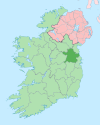
Batterstown
Batterstown
Baile an Bhóthair | |
|---|---|
Village | |
 Pub in Batterstown | |
| Coordinates: 53°28′11″N 6°32′11″W / 53.4697°N 6.5364°W | |
| Country | Ireland |
| Province | Leinster |
| County | County Meath |
| Time zone | UTC+0 (WET) |
| • Summer (DST) | UTC-1 (IST (WEST)) |
Batterstown (Irish: Baile an Bhóthair, meaning 'town of the road')[1] is a small rural village in the townland of Rathregan (Ráth Riagáin), County Meath, Ireland. It is about 23 km (14 mi) northwest of Dublin, on the R154 regional road.[2] It hosts a yearly cycling race.[3] There are approximately forty houses in Batterstown. The population of Batterstown is approximately 150 people.[citation needed]
Facilities
[edit]A primary school (Rathregan National School) is in Batterstown. The post office was closed in 2018.[4]
Sport
[edit]The local Batterstown Gaelic Athletic Association club is Blackhall Gaels GAA. Batterstown holds the club's main training ground. The club fields Gaelic football, Ladies' Gaelic football, hurling and camogie teams.[5]
Transport
[edit]Batterstown railway station on the Dublin–Navan railway line opened on 1 July 1863, was closed for passenger traffic on 27 January 1947, closed for goods traffic on 12 June 1961, and finally closed altogether on 1 April 1963.[6] The village is served by the Bus Éireann 111 Athboy to Dublin service.[7] Under the Bus Éireann M3 Corridor - Bus Services to Dublin & Local Centres Proposals announced in 2015, this route has enhanced services with hourly service off peak and more frequent during the morning rush hours.[8][9]
See also
[edit]References
[edit]- ^ Placenames Database of Ireland
- ^ "Batterstown, Co Meath". Archived from the original on 28 September 2007.
- ^ "www.cyclingnews.com - the world centre of cycling".
- ^ John Donohoe (1 August 2018). "Seven post offices across Meath to close". Meath Chronicle. Retrieved 7 January 2019.
- ^ "Blackhall Gaels GAA Club".
- ^ "Batterstown station" (PDF). Railscot - Irish Railways. Archived (PDF) from the original on 26 September 2007. Retrieved 12 September 2007.
- ^ A4 Portrait101-200.qxd[permanent dead link]
- ^ "111 Athboy-Trim-Batterstown-Dublin" (PDF). Bus Eireann. Archived from the original (PDF) on 8 January 2019. Retrieved 7 January 2019.
- ^ "111X Clonmellon - Delvin - Athboy - (Trim) - Dublin" (PDF). Bus Eireann. Archived from the original (PDF) on 8 January 2019. Retrieved 7 January 2019.


