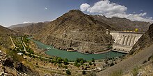
Kürpsay Dam
Appearance
| Kürpsay Dam | |
|---|---|
 Kürpsay dam July 2012 | |
| Official name | Курпсайская ГЭС |
| Country | Kyrgyzstan |
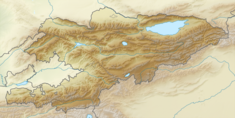
| Coordinates | 41°29′56″N 72°21′51″E / 41.49889°N 72.36417°E |
| Status | Operational |
| Dam and spillways | |
| Type of dam | Gravity |
| Impounds | Naryn |
| Height | 113 m (371 ft) |
| Reservoir | |
| Total capacity | 370,000,000 m3 (299,964 acre⋅ft) |
| Active capacity | 35,000,000 m3 (28,375 acre⋅ft) |
| Power Station | |
| Commission date | 1976 |
| Turbines | 4 |
| Installed capacity | 800 MW |
| Annual generation | 2.63 billion kWh |
The Kürpsay Dam (Kyrgyz: Күрпсай плотинасы) is a gravity dam on the river Naryn in Jalal-Abad Region of Kyrgyzstan, downstream from the Toktogul Dam. It is 113 m (371 ft) tall and creates a 370,000,000 m3 (299,964 acre⋅ft) reservoir of which 27,000,000 m3 (21,889 acre⋅ft) is active (or useful) for power generation.[1] The installed capacity of the power station is 800 MW.[2] Construction was started in 1976, and the first electricity was supplied in 1981.[1]
References
- ^ a b "Toktogul cascade of HPP" (in Russian). Energo-ES. Retrieved 14 January 2022.
- ^ "List of major hydroelectric facilities Kyrgyzskoy Republic" (PDF) (in Russian). CA Water. Retrieved 24 February 2012.

