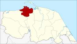
Mueang Pattani district
Mueang Pattani
เมืองปัตตานี | |
|---|---|
 Krue Se Mosque in Tambon Tanyong Lulo | |
 District location in Pattani province | |
| Coordinates: 6°52′7″N 101°15′0″E / 6.86861°N 101.25000°E | |
| Country | Thailand |
| Province | Pattani |
| Tambon | 13 |
| Muban | 66 |
| Area | |
| • Total | 96.869 km2 (37.401 sq mi) |
| Population (6 November 2002) | |
| • Total | 127,531 |
| • Density | 1,221.3/km2 (3,163/sq mi) |
| Time zone | UTC+7 (ICT) |
| Postal code | 94000 |
| Geocode | 9401 |
Mueang Pattani (Template:Lang-th, pronounced [mɯ̄a̯ŋ pàt.tāː.nīː]) is the capital district (amphoe mueang) of Pattani province, southern Thailand.
History
This area was the center of the Pattani Kingdom. In the reign of King Rama II, the king ordered the kingdom divided into seven cities (mueang): Pattani, Yaha, Yaring, Nong Chik, Ra-ngae, Raman, and Sai Buri. It was made a district in 1901. Pattani was the central district of Monthon Pattani when King Rama V created the monthon in 1906.
In 1917 the district was renamed Sabarang, the name of the central sub-district.[1] In 1938 the name was changed back to Mueang Pattani.[2]
Geography
Neighboring districts are (from the east clockwise): Yaring, Yarang, and Nong Chik. To the north is the Gulf of Thailand.
The important water resource is the Tani River.
Administration
Central administration
Mueang Pattani is divided into 13 sub-districts (tambons), which are further subdivided into 66 administrative villages (mubans).
| No. | Name | Thai | Villages | Pop.[3] |
|---|---|---|---|---|
| 1. | Sabarang | สะบารัง | - | 25,438 |
| 2. | Anoru | อาเนาะรู | - | 10,766 |
| 3. | Chabang Tiko | จะบังติกอ | - | 8,030 |
| 4. | Bana | บานา | 11 | 20,068 |
| 5. | Tanyong Lulo | ตันหยงลุโละ | 3 | 6,583 |
| 6. | Khlong Maning | คลองมานิง | 4 | 3,502 |
| 7. | Kamiyo | กะมิยอ | 7 | 4,683 |
| 8. | Barahom | บาราโหม | 3 | 3,024 |
| 9. | Pakaharang | ปะกาฮะรัง | 8 | 5,571 |
| 10. | Rusamilae | รูสะมิแล | 6 | 17,810 |
| 11. | Talubo | ตะลุโบะ | 9 | 7,595 |
| 12. | Baraho | บาราเฮาะ | 8 | 7,346 |
| 13. | Puyut | ปุยุด | 7 | 7,115 |
Local administration
There is one town (thesaban mueang) in the district: Pattani (Thai: เทศบาลเมืองปัตตานี) consisting of sub-districts Sabarang, Anoru, and Chabang Tiko.
There is one sub-district municipality (thesaban tambon) in the district: Rusamilae (Thai: เทศบาลตำบลรูสะมิแล) consisting of sub-district Rusa Milae.
There are nine sub-district administrative organizations (SAO) in the district:
- Bana (Thai: องค์การบริหารส่วนตำบลบานา) consisting of sub-district Bana.
- Tanyong Lulo (Thai: องค์การบริหารส่วนตำบลตันหยงลุโละ) consisting of sub-district Tanyong Lulo.
- Khlong Maning (Thai: องค์การบริหารส่วนตำบลคลองมานิง) consisting of sub-district Khlong Maning.
- Kamiyo (Thai: องค์การบริหารส่วนตำบลกะมิยอ) consisting of sub-district Kamiyo.
- Barahom (Thai: องค์การบริหารส่วนตำบลบาราโหม) consisting of sub-district Barahom.
- Pakaharang (Thai: องค์การบริหารส่วนตำบลปะกาฮะรัง) consisting of sub-district Pakaharang.
- Talubo (Thai: องค์การบริหารส่วนตำบลตะลุโบะ) consisting of sub-district Talubo.
- Baraho (Thai: องค์การบริหารส่วนตำบลบาราเฮาะ) consisting of sub-district Baraho.
- Puyut (Thai: องค์การบริหารส่วนตำบลปุยุด) consisting of sub-district Puyut.
References
- ^ "ประกาศกระทรวงมหาดไทย เรื่อง เปลี่ยนชื่ออำเภอ" (PDF). Royal Gazette (in Thai). 34 (ก): 40–68. 1917-04-29. Archived from the original (PDF) on November 7, 2011.
- ^ "พระราชกฤษฎีกาเปลี่ยนนามจังหวัด และอำเภอบางแห่ง พุทธศักราช ๒๔๘๑" (PDF). Royal Gazette (in Thai). 55 (ก): 658–666. 1938-11-14. Archived from the original (PDF) on November 8, 2011.
- ^ "Population statistics 2014" (in Thai). Department of Provincial Administration. Retrieved 2015-06-04.
External links
- amphoe.com on Mueang Pattani District
