Ega (river)
Appearance
| Ega | |
|---|---|
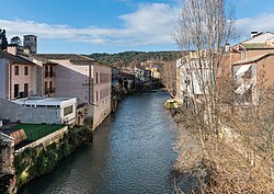
 The Ega river in Estella-Lizarra | |
| Location | |
| Country | Spain |
| Physical characteristics | |
| Source | |
| • location | Álava |
| • coordinates | 42°37′10″N 2°36′46″W / 42.61944°N 2.61278°W |
| Mouth | |
• location | Ebro |
• coordinates | 42°19′42″N 1°55′10″W / 42.32833°N 1.91944°W |
| Basin features | |
| Progression | Ebro→ Balearic Sea |
The Ega is a river in the north of Spain. It is a tributary of the Ebro, which in turn empties into the Blearic Sea. The Ega flows through Navarre, but it originates in Álava, near Lagrán, and flows through the town of Estella-Lizarra.
See also
[edit]
