
San Sebastián de La Gomera
| San Sebastián de la Gomera | |
| Map | |
|---|---|

| |
| Statistics | |
| Autonomous region: | Canary Islands |
| Province: | Santa Cruz de Tenerife |
| Island: | La Gomera |
| Area: | 114.47 km² (113.59 km² in 2003) |
| Population: | 7,984 (2001) |
| Population density: | 69.75/km² |
| Elevation: Lowest: Centre: Highest: |
Atlantic Ocean 5 m western part |
| Postal code: | E-38880 |
| Location: | 28.1/28°6' N lat. 17.1/17°6' W long. |
| Car designation: | TF
|
San Sebastián de la Gomera is a town (the main port and capital) and also an administrative district on La Gomera in the Canary Islands. Its population is 2,176 (ISTAC, 2004), its density is 47.6/km² and the area is 114.78 km².
Part of the area is made up of farmlands, while the mountainous areas are forested or grassy. Its main industries are agriculture, tourism and administrative. Houses run up within the small stream up to the hills and the mountains surround the capital. The port is in the east and within the port is its beach. The port serves ferry routes to the islands of Tenerife, La Palma and El Hierro. Streets include Calle Real and F. Olsen, which link the port. The residential and business areas runs from southeast to northwest. A bus station named Estatión de Guaguas is used for bus lines throughout the island; it is located on Avenida Quinta Centenario. Much of the hills are grassy and almost entirely deforested, farms are in the valley and up to fields northeast and more mountains to the northeast.
Historical population
| Year | Population | Change | Density |
|---|---|---|---|
| 1991 | 5,606 | - | - |
| 1996 | 6,199 | - | - |
| 2001 | 6,618 | - | 50.95/km² |
| 2002 | 7,138 | - | - |
| 2003 | 6,902 | - | 54.63/km² |
| 2004 | 7,984 | - | 55.62/km² |
The population increased until 2002 when it suffered a decrease in 2003, the population became the fastest in the island as it boomed about 13.5% population.
History
The area before the founding of the municipality were inhabited by the Guanches. Hernán Peraza arrived in 1440. Christopher Columbus stopped at the harbour in September 6, 1492 before heading to India but headed for America instead.
Sites of interest
- Torre del Conde - a tower in the middle of the valley
- Casa del Colón, a museum dedicated to Christopher Columbus
- Casa de los Peraza
- Pozo de La Aguada
- Iglesia de La Asunción and Ermita de San Sebastián Churches
- Barranco del Cabrito
- Los Roques rocks
- Puntallana
- Majona Nature Park
Tourism
The port serves as a hub for tourists being ferries from the nearby island of Tenerife. Main firms include Fred. Olsen Express and Naviera Armas.
Economy
The economy of San Sebastián de La Gomera is centered on the functions of the capital and its port, as well as in the public sector, particularly in the transportation, trading, and tourism of Tenerife. The primary industry until the 1990s was primarily agriculture.
Other
San Sebastián de la Gomera has schools, a few lyceums, a gymnasium, churches, a small beach, a post office and a few squares plazas, one of them named Plaza de las Americas.
Pictures
-
 San Sebastián de La Gomera
 -
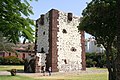 Torre del conde
 -
 Church Iglesia de La Asunción
 -
The small Fred. Olsen Express ferry.
-
One of the Naviera Armas ferries.
-
The big Fred. Olsen Express ferry.


External links
- Map and aerial photos
- Street map: Street map from Mapquest, MapPoint or Google
- Satellite images: Google
- Coordinates: 28°6′0″N 17°6′0″W / 28.10000°N 17.10000°W
See also
| Northwest: Hermigua | North: Atlantic Ocean | |
| West: Alajeró and Hermigua | San Sebastián de la Gomera | East: Atlantic Ocean |
| Southwest: Alajeró | South: Atlantic Ocean |